Corbett · North-West Highlands
Fuar Tholl
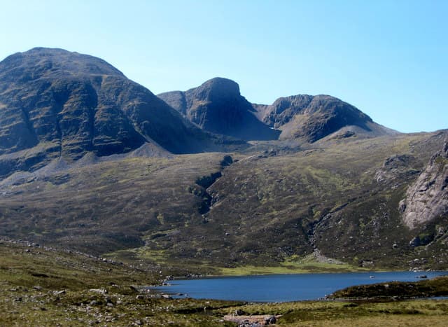
Fuar Tholl is the great hooked Corbett above Achnashellach in Wester Ross, and arguably the most photogenic mountains on the railway line between Inverness and Kyle of Lochalsh. The north face is dominated by the Mainreachan Buttress — a serious rock-climbing objective famous for its long sandstone routes — and the summit ridge curves round above it in a distinctive hook visible from miles down Glen Carron. At 907m it lies within striking distance of Munro height — frustratingly so for the local folklore — and earns its place as a fine hill day in its own right rather than a Munro consolation.
Quick facts
- Height
- 907m/ 2976ft
- Prominence
- 242 m
- Distance
- 17 km
- Ascent
- 950 m
- Time
- 5–8 hrs
- Grid ref
- NG975489
- Parking
- NH004483
- Nearest
- Ullapool· Inverness 69km
- Dogs
- Dogs on lead required near livestockDog-friendly guide ↗
Height and prominence cross-checked against the Database of British and Irish Hills (CC BY).
No GPX track yet
Walked this route? Share your track to help other walkers.
Standard route
railway path 15% · stalkers path 25% · rocky ridge 40% · summit scramble 20%
The standard route starts from Achnashellach railway station. Walk back along the A890 a short distance, then take the forestry track north into Coire Lair, climbing through ancient Caledonian pine. At the open mouth of the corrie the path branches: take the south-easterly stalkers' line up onto the broad south-east ridge, then follow the ridge north-west over slabby sandstone to the summit cairn perched above the Mainreachan cliffs. Return by the same route, or descend west into Coire Lair if conditions allow. Allow 7–8 hours.
Terrain
Good stalkers' paths in the lower corrie. Above the bealach the terrain is rough sandstone slab and quartzite blocks — sound underfoot but slippery in the wet. The summit is small and exposed, sitting directly above the Mainreachan Buttress; keep clear of the north edge in poor visibility.
In winter
In hard winter Fuar Tholl is a serious objective with the Mainreachan face holding ice routes and the summit ridge fully exposed. Standard walker's route needs full winter kit and care on the slabby upper sandstone, where verglas forms readily. The approach through Coire Lair gives good visibility of conditions on the cliffs before you commit.
This hill is in the Torridon SAIS forecast area. Check SAIS forecasts in winter (December–April).
Best time of year
Getting there
- Glasgow4h 43m
- Edinburgh4h 10m
OS maps: OS Landranger 25
Mobile signal: The hill itself is blank; intermittent EE/Vodafone at Achnashellach station and along the A890 near Strathcarron
Current conditions
Daylight Today
- Sunrise
- 04:43
- Sunset
- 22:12
- Civil dawn
- 03:39
- Civil dusk
- 23:15
NOAA Solar Calculator · 13 July 2026
Pair with
Curated multi-hill combinations from Fuar Tholl.
Around Fuar Tholl on the SCOT network
Getting there, basing yourself, and what to do off the hill.
Fuar Tholl — common questions
- What difficulty is Fuar Tholl?
- On the OutdoorSCOT scale, Fuar Tholl comes in at 3/5 — moderately challenging. Expect roughly 17km and 950m of ascent on the usual route — 5-8 hours for most parties. Underfoot: Good stalkers' paths in the lower corrie.
- What is Fuar Tholl's prominence?
- 242m of prominence. That's the vertical drop from the summit to the col that links Fuar Tholl to the next higher ground.
- Where do I park for Fuar Tholl?
- Most walkers start from NH004483 near Ullapool. Verify the grid reference on an OS map before you set off — space is tight on busy summer weekends.
- When is the best time to climb Fuar Tholl?
- May, June, July, August, September give the most reliable conditions on Fuar Tholl. Beyond that window the high ground turns wintry: carry full mountain kit, be confident navigating, and check the SAIS avalanche forecast for the area.
- Is Fuar Tholl dog-friendly?
- Yes, but dogs must be kept on a lead — there is livestock or ground-nesting bird interest on the route.
- Is there mobile signal on Fuar Tholl?
- The hill itself is blank; intermittent EE/Vodafone at Achnashellach station and along the A890 near Strathcarron
- Is Fuar Tholl safe in winter?
- In hard winter Fuar Tholl is a serious objective with the Mainreachan face holding ice routes and the summit ridge fully exposed. Standard walker's route needs full winter kit and care on the slabby upper sandstone, where verglas forms readily. The approach through Coire Lair gives good visibility of conditions on the cliffs before you commit.
Get the OutdoorSCOT weekly
One email a week — new route, hill and bothy guides, seasonal conditions and the odd hard-won lesson. No spam, unsubscribe in one click.