Corbett · North-West Highlands
An Ruadh-Stac
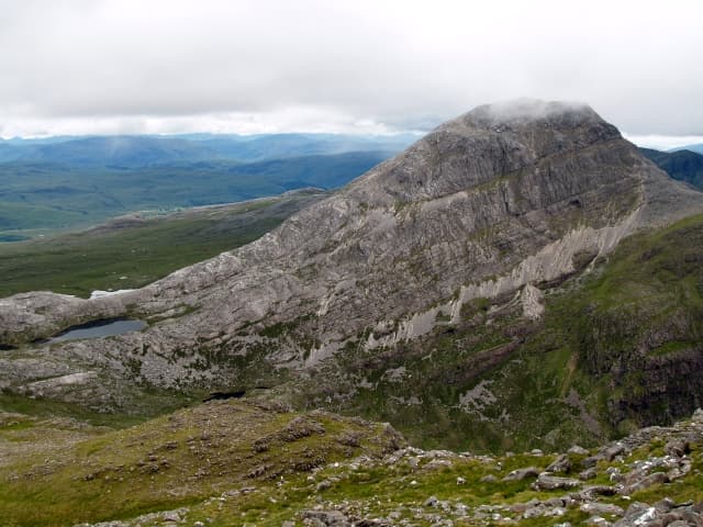
An Ruadh-Stac — 'the red peak' — is the striking white-quartzite cone rising south of Maol Chean-dearg in the Coulin forest above Coulags. From any angle it looks like a small Cuillin top transplanted into Wester Ross: pale, steep, and obviously made of rock rather than grass. The summit can be reached via a steep boulder slope from the bealach below Maol Chean-dearg, and the views back to Liathach and across to the Torridon giants are the payoff. A short hill day by the metrics, but rough underfoot the whole way.
Gaelic: “the, red” · Pronunciation: an roo-ah stac
Quick facts
- Height
- 890.4m/ 2921ft
- Prominence
- 327 m
- Distance
- ~14 km
- Ascent
- ~920 m
- Time
- 4–7 hrs
- Grid ref
- NG921480
- Parking
- NG958481
- Nearest
- Ullapool· Inverness 74km
- Dogs
- Dogs on lead required near livestockDog-friendly guide ↗
Height and prominence cross-checked against the Database of British and Irish Hills (CC BY).
No GPX track yet
Walked this route? Share your track to help other walkers.
Standard route
pinewood path 25% · open hillside 25% · quartzite blocks 40% · summit rocks 10%
Start at the parking layby at Coulags on the A890 between Strathcarron and Lochcarron. A good stalkers' path follows the Fionn-abhainn north into the Coulin forest. After around 4km, branch west at the bealach below Maol Chean-dearg — the path becomes vague and the terrain steepens. The final climb to An Ruadh-Stac is a steep block-slope of pale quartzite, slow but stable. Return by the same line, or extend by including Maol Chean-dearg for a long but rewarding double. Allow 6–7 hours for An Ruadh-Stac alone.
Terrain
Good lower path through the Coulin pinewoods. From the bealach upwards the path disappears and the route follows steep quartzite blocks to the summit. The blocks are large and stable but tiring to ascend, slow to descend, and slippery when wet. The summit itself is small and exposed.
In winter
In winter An Ruadh-Stac's quartzite slope becomes a serious objective — the blocks freeze into a smooth slab and crampons can struggle to bite. The Coulin forest approach holds snow late and the descent is committing in poor visibility. Best in firm consolidated winter conditions; avoid in fresh snow on the upper face.
Kit for this: the winter Munro kit list · which boots take crampons
This hill is in the Torridon SAIS forecast area. Check SAIS forecasts in winter (December–April).
Best time of year
Getting there
- Glasgow4h 44m
- Edinburgh4h 13m
OS maps: OS Landranger 25
Mobile signal: No signal in the Coulin forest; intermittent EE/Vodafone on the A890 at Coulags
Current conditions
Daylight Today
- Sunrise
- 07:53
- Sunset
- 18:23
- Civil dawn
- 07:14
- Civil dusk
- 19:02
NOAA Solar Calculator · 14 October 2026
Pair with
Curated multi-hill combinations from An Ruadh-Stac.
Around An Ruadh-Stac on the SCOT network
Getting there, basing yourself, and what to do off the hill.
An Ruadh-Stac — common questions
- What difficulty is An Ruadh-Stac?
- On the OutdoorSCOT scale, An Ruadh-Stac comes in at 3/5 — moderately challenging. Expect roughly 14km and 920m of ascent on the usual route — 4-7 hours for most parties. Underfoot: Good lower path through the Coulin pinewoods.
- What is An Ruadh-Stac's prominence?
- 327m of prominence. That's the vertical drop from the summit to the col that links An Ruadh-Stac to the next higher ground.
- Where do I park for An Ruadh-Stac?
- Most walkers start from NG958481 near Ullapool. Verify the grid reference on an OS map before you set off — space is tight on busy summer weekends.
- When is the best time to climb An Ruadh-Stac?
- April, May, June, July, August, September, October give the most reliable conditions on An Ruadh-Stac. Beyond that window the high ground turns wintry: carry full mountain kit, be confident navigating, and check the SAIS avalanche forecast for the area.
- Is An Ruadh-Stac dog-friendly?
- Yes, but dogs must be kept on a lead — there is livestock or ground-nesting bird interest on the route.
- Is there mobile signal on An Ruadh-Stac?
- No signal in the Coulin forest; intermittent EE/Vodafone on the A890 at Coulags
- Is An Ruadh-Stac safe in winter?
- In winter An Ruadh-Stac's quartzite slope becomes a serious objective — the blocks freeze into a smooth slab and crampons can struggle to bite. The Coulin forest approach holds snow late and the descent is committing in poor visibility. Best in firm consolidated winter conditions; avoid in fresh snow on the upper face.
Get the OutdoorSCOT weekly
One email a week — new route, hill and bothy guides, seasonal conditions and the odd hard-won lesson. No spam, unsubscribe in one click.