Graham · North-West Highlands
Sgurr a' Gharaidh
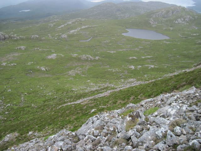
A craggy Graham rising directly from the south shore of Loch Carron, west of Lochcarron village. Its complex of crags and lochans makes it feel like a much bigger hill than 732m suggests.
Quick facts
- Height
- 732.3m/ 2403ft
- Prominence
- 333 m
- Distance
- 14 km
- Ascent
- 600 m
- Time
- 4–7 hrs
- Grid ref
- NG884443
- Parking
- NG900452
- Nearest
- Ullapool· Inverness 78km
- Dogs
- Dogs on lead required near livestockDog-friendly guide ↗
Height and prominence cross-checked against the Database of British and Irish Hills (CC BY).
No GPX track yet
Walked this route? Share your track to help other walkers.
Standard route
road access 15% · heather hillside 50% · grassy ridge 25% · summit area 10%
Start from the New Kelso forestry car park west of Lochcarron. Follow the forest road into Coire na Sgairde, then break south-west onto open hillside. The summit is reached by a winding line between sandstone outcrops and small lochans.
Terrain
Forest road, then heather, slabby Torridonian sandstone and bog around the summit lochans. Navigation through the upper crag system requires concentration — there are several false summits.
In winter
The complex summit terrain becomes a navigation puzzle in cloud. Snow tends to drift into the lochan hollows and disguise wet ground. Loch Carron weather can switch from clear to whiteout in under an hour.
This hill is in the Torridon SAIS forecast area. Check SAIS forecasts in winter (December–April).
Best time of year
Getting there
- Glasgow4h 42m
- Edinburgh4h 12m
OS maps: OS Landranger 24
Mobile signal: Signal in Lochcarron village; gone within five minutes of leaving the road
Current conditions
Daylight Today
- Sunrise
- 04:50
- Sunset
- 22:07
- Civil dawn
- 03:49
- Civil dusk
- 23:07
NOAA Solar Calculator · 17 July 2026
Around Sgurr a' Gharaidh on the SCOT network
Getting there, basing yourself, and what to do off the hill.
Sgurr a' Gharaidh — common questions
- What difficulty is Sgurr a' Gharaidh?
- On the OutdoorSCOT scale, Sgurr a' Gharaidh comes in at 4/5 — challenging. Expect roughly 14km and 600m of ascent on the usual route — 4-7 hours for most parties. Ground conditions: Forest road, then heather, slabby Torridonian sandstone and bog around the summit lochans.
- How much drop does Sgurr a' Gharaidh have?
- The drop is 333m: measured from the summit of Sgurr a' Gharaidh down to the saddle joining it to higher terrain.
- Where's the parking for Sgurr a' Gharaidh?
- Park at NG900452 near Ullapool. Double-check the grid reference on an OS map first; informal laybys here fill early in high season.
- What's the best month to climb Sgurr a' Gharaidh?
- Aim for May, June, July, August, September on Sgurr a' Gharaidh. In the remaining months treat it as a winter hill — full kit, solid navigation, and a look at the relevant SAIS avalanche forecast before you go.
- Can dogs go up Sgurr a' Gharaidh?
- Dogs are fine on a lead. The route passes livestock or ground-nesting bird habitat, so keep them close throughout.
- Will I get phone signal on Sgurr a' Gharaidh?
- Signal in Lochcarron village; gone within five minutes of leaving the road
- Is Sgurr a' Gharaidh safe in winter?
- The complex summit terrain becomes a navigation puzzle in cloud. Snow tends to drift into the lochan hollows and disguise wet ground. Loch Carron weather can switch from clear to whiteout in under an hour.
Get the OutdoorSCOT weekly
One email a week — new route, hill and bothy guides, seasonal conditions and the odd hard-won lesson. No spam, unsubscribe in one click.