Graham · North-West Highlands
An Ruadh-mheallan
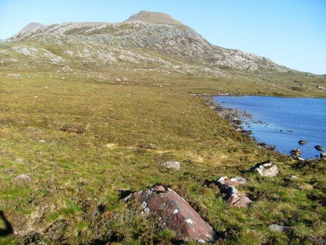
An Ruadh-mheallan (671m) — the red lump — is a striking Torridonian sandstone hill in NG86, set above the road from Diabaig and looking straight across Loch Torridon to Beinn Alligin. The summit boulder caps a dramatic terraced cone of red sandstone that glows in evening light. Despite its modest height, the panorama south to the Liathach skyline is one of the finest in Wester Ross.
Gaelic: “the, red” · Pronunciation: an roo-ah mheallan
Quick facts
- Height
- 671.7m/ 2204ft
- Prominence
- 201 m
- Distance
- 13 km
- Ascent
- 550 m
- Time
- 4–6 hrs
- Grid ref
- NG836614
- Parking
- NG842617
- Nearest
- Ullapool· Inverness 84km
- Dogs
- Dogs on lead required near livestockDog-friendly guide ↗
Height and prominence cross-checked against the Database of British and Irish Hills (CC BY).
No GPX track yet
Walked this route? Share your track to help other walkers.
Standard route
heather moorland 60% · grass slopes 25% · rocky summit 15%
Park at the road bend just north of the Bealach na Gaoithe between Torridon and Diabaig. A faint path climbs east-north-east up the steep sandstone shelves, gaining height fast on grippy slabs and short grass terraces. The summit boulder marks the highest point of the broad rocky dome — return by the same line or descend cautiously to the south-east toward Loch a' Mhullaich.
Terrain
Stepped Torridonian sandstone slabs from very low down, with grass terraces between. The rock grips superbly when dry but is slick in rain. The summit dome is a maze of small outcrops and lochans — line of sight only between cairns.
In winter
The Torridonian terraces freeze hard in any cold snap and the climb becomes a serious mountaineering proposition with verglas on every slab. Atlantic storms barrel in from the open Minch giving little warning. SAIS Torridon forecasts apply — though steep snow is rarer here than on the Munros opposite.
This hill is in the Torridon SAIS forecast area. Check SAIS forecasts in winter (December–April).
Best time of year
Getting there
- Glasgow4h 2m
- Edinburgh5h 31m
OS maps: OS Landranger 19, OS Landranger 24
Mobile signal: Minimal. Remote Torridon hinterland; weak on most networks.
Current conditions
Daylight Today
- Sunrise
- 04:43
- Sunset
- 22:14
- Civil dawn
- 03:39
- Civil dusk
- 23:18
NOAA Solar Calculator · 13 July 2026
Around An Ruadh-mheallan on the SCOT network
Getting there, basing yourself, and what to do off the hill.
An Ruadh-mheallan — common questions
- Is An Ruadh-mheallan a hard climb?
- An Ruadh-mheallan is rated 4/5 (challenging) on the OutdoorSCOT scale. The standard route covers about 13km with 550m of ascent and takes most walkers 4-6 hours. Underfoot: Stepped Torridonian sandstone slabs from very low down, with grass terraces between.
- What is An Ruadh-mheallan's prominence?
- 201m of prominence. That's the vertical drop from the summit to the col that links An Ruadh-mheallan to the next higher ground.
- Where do I park for An Ruadh-mheallan?
- Most walkers start from NG842617 near Ullapool. Verify the grid reference on an OS map before you set off — space is tight on busy summer weekends.
- When is the best time to climb An Ruadh-mheallan?
- May, June, July, August, September give the most reliable conditions on An Ruadh-mheallan. Beyond that window the high ground turns wintry: carry full mountain kit, be confident navigating, and check the SAIS avalanche forecast for the area.
- Is An Ruadh-mheallan dog-friendly?
- Yes, but dogs must be kept on a lead — there is livestock or ground-nesting bird interest on the route.
- Is there mobile signal on An Ruadh-mheallan?
- Minimal. Remote Torridon hinterland; weak on most networks.
- Is An Ruadh-mheallan safe in winter?
- The Torridonian terraces freeze hard in any cold snap and the climb becomes a serious mountaineering proposition with verglas on every slab. Atlantic storms barrel in from the open Minch giving little warning. SAIS Torridon forecasts apply — though steep snow is rarer here than on the Munros opposite.
Get the OutdoorSCOT weekly
One email a week — new route, hill and bothy guides, seasonal conditions and the odd hard-won lesson. No spam, unsubscribe in one click.