Munro · North-West Highlands
Beinn Alligin - Sgurr Mor
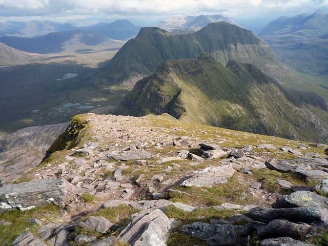
Sgùrr Mòr (986m) is the higher of the two Munros on Beinn Alligin — "the jewelled mountain" — the dramatic Torridon peak that crowns the north side of upper Loch Torridon. Together with the second Munro Tom na Gruagaich and the famously airy Horns of Alligin (three rocky pinnacles requiring Grade 1/2 scrambling), Beinn Alligin offers one of the great traverse rounds in the Northern Highlands. The summit cairn is unmistakable — a huge stone-built tower visible from Liathach across the glen.
Gaelic: “mountain, sharp peak, big” · Pronunciation: bine alligin skoor more
Quick facts
- Height
- 986m/ 3235ft
- Prominence
- 601 m
- Distance
- 17 km
- Ascent
- 868 m
- Time
- 6–9 hrs
- Grid ref
- NG865612
- Parking
- NG869576
- Nearest
- Ullapool· Inverness 81km
- Dogs
- Dogs on lead required near livestockDog-friendly guide ↗
Height and prominence cross-checked against the Database of British and Irish Hills (CC BY).
No GPX track yet
Walked this route? Share your track to help other walkers.
Standard route
Moorland path 25% · Steep hillside 30% · Horns scramble 45%
Park at the Coire Mhic Nobuil bridge car park on the Diabaig road from Torridon village. Take the path north up the Allt a' Bhealaich, then climb west onto Tom na Gruagaich (the first Munro). Continue north along the high crest, dropping into the famously deep Cleft of Alligin, then on to Sgùrr Mòr. Most parties continue east over the three Horns of Alligin (Grade 1/2 scrambling) and descend back to the car park. Around 11km with 1200m of ascent for the full round.
Terrain
The Coire Mhic Nobuil path is excellent restored pitching for the lower section. The climb onto Tom na Gruagaich is sustained on steep grass with one or two short scrambly steps. The Cleft of Alligin — the great vertical gash on the south side of the ridge — is a stunning feature but means the path stays back from the edge. The Horns of Alligin scrambling line offers Grade 1/2 on bare sandstone with airy moves; the bypass on the north side is straightforward grass.
In winter
A major Torridon winter mountaineering objective. The Horns of Alligin become a serious Grade I/II winter scramble. The summit ridge sandstone glazes readily with verglas. The Cleft of Alligin is a notorious cornicing feature — keep well clear of the south edge in cloud. The Diabaig road can drift but the A896 corridor stays gritted. Phone signal absent above 300m. SAIS Torridon applies.
This hill is in the Torridon SAIS forecast area. Check SAIS forecasts in winter (December–April).
Best time of year
Getting there
- Glasgow4h 1m
- Edinburgh4h 29m
OS maps: OS Landranger 19, OS Landranger 24
Mobile signal: Limited signal at Torridon village car park. No reception above 300m on Beinn Alligin. Very remote Torridon environment.
Current conditions
Daylight Today
- Sunrise
- 05:00
- Sunset
- 21:58
- Civil dawn
- 04:02
- Civil dusk
- 22:55
NOAA Solar Calculator · 23 July 2026
Pair with
Curated multi-hill combinations from Beinn Alligin - Sgurr Mor.
Around Beinn Alligin - Sgurr Mor on the SCOT network
Getting there, basing yourself, and what to do off the hill.
Beinn Alligin - Sgurr Mor — common questions
- How difficult is Beinn Alligin - Sgurr Mor?
- Beinn Alligin - Sgurr Mor carries a 5/5 (very challenging) grade on the OutdoorSCOT scale. Count on about 17km, 868m of ascent and a 6-9 hour day on the standard route. Terrain: The Coire Mhic Nobuil path is excellent restored pitching for the lower section.
- How prominent is Beinn Alligin - Sgurr Mor?
- Beinn Alligin - Sgurr Mor has 601m of topographic prominence — the height of its summit above the highest col connecting it to higher ground.
- Where should I park to climb Beinn Alligin - Sgurr Mor?
- Standard parking is at NG869576 near Ullapool. Check the parking grid reference on an OS map before travel; informal laybys can fill on summer weekends.
- When should I climb Beinn Alligin - Sgurr Mor?
- The standard good-weather months for Beinn Alligin - Sgurr Mor are May, June, July, August, September. Outside those months, expect winter conditions on the high ground — full mountain kit, navigation skills, and a check of the SAIS avalanche forecast for the relevant region.
- Can I bring my dog up Beinn Alligin - Sgurr Mor?
- On a lead only — the route crosses ground with livestock or nesting-bird interest.
- What's mobile reception like on Beinn Alligin - Sgurr Mor?
- Limited signal at Torridon village car park. No reception above 300m on Beinn Alligin. Very remote Torridon environment.
- Is Beinn Alligin - Sgurr Mor safe in winter?
- A major Torridon winter mountaineering objective. The Horns of Alligin become a serious Grade I/II winter scramble. The summit ridge sandstone glazes readily with verglas. The Cleft of Alligin is a notorious cornicing feature — keep well clear of the south edge in cloud. The Diabaig road can drift but the A896 corridor stays gritted. Phone signal absent above 300m. SAIS Torridon applies.
Get the OutdoorSCOT weekly
One email a week — new route, hill and bothy guides, seasonal conditions and the odd hard-won lesson. No spam, unsubscribe in one click.