Corbett · North-West Highlands
Baosbheinn
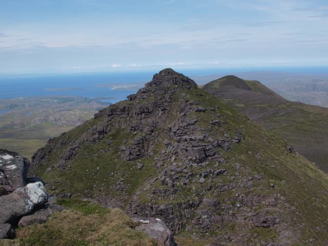
Baosbheinn — "the wizard's hill" — is the longest of the three great sandstone ridges that rise out of the Flowerdale Forest in the wild country north-west of Beinn Eighe. From the Red Barn car park on the road between Gairloch and Loch Maree it looks like a fortress wall, but from the south the same hill becomes a slender 3km ridge with three distinct sandstone tops. At 875m the highest of these, Sgorr Dubh, gives an outstanding seaward view across the Minch to Skye and the Outer Hebrides.
Quick facts
- Height
- 875m/ 2871ft
- Prominence
- 443 m
- Distance
- 16 km
- Ascent
- 770 m
- Time
- 6–9 hrs
- Grid ref
- NG870654
- Parking
- NG857721
- Nearest
- Ullapool· Inverness 82km
- Dogs
- Dogs on lead required near livestockDog-friendly guide ↗
Height and prominence cross-checked against the Database of British and Irish Hills (CC BY).
No GPX track yet
Walked this route? Share your track to help other walkers.
Standard route
moorland path 20% · rough ground 30% · sandstone ridge 35% · pinnacle scramble 15%
The standard line starts at the Red Barn lay-by on the A832 and follows the stalkers path south-east towards Loch na h-Oidhche for around 4km. Where the path crosses the outflow stream, leave it and climb the north-east shoulder of Baosbheinn onto the long ridge, then traverse south-west over the intermediate top of Ceann Beag to the main summit. Around 18km return with 770m of ascent. The Flowerdale path is firm; the ridge itself is bare Torridonian sandstone in big weathered blocks.
Terrain
The Flowerdale path is well-engineered and a pleasure to walk. Once off it the going turns hard — a steep heather and bilberry pull onto the ridge, then big Torridonian sandstone blocks and short rocky steps along the crest. There is a small step on the descent off Ceann Beag that needs a hand on rock in the wet. No actual exposure but plenty of ankle-twisting boulder hopping. Pathless on the ridge — follow cairns where you can find them.
In winter
In winter Baosbheinn turns into a real mountaineering proposition for such a low summit. The north-east shoulder is the obvious avalanche slope after westerly storms and the sandstone blocks of the ridge ice up quickly. A full traverse in winter is a long committing day in remote country with nothing within shouting distance for help. Mid-March to April often gives the best combination of light, snow stability and underfoot conditions.
This hill is in the Torridon SAIS forecast area. Check SAIS forecasts in winter (December–April).
Best time of year
Getting there
- Glasgow4h 5m
- Edinburgh5h 32m
OS maps: OS Landranger 19, OS Landranger 24
Mobile signal: No signal in Gairloch area hills; completely off-network
Current conditions
Daylight Today
- Sunrise
- 04:42
- Sunset
- 22:14
- Civil dawn
- 03:38
- Civil dusk
- 23:18
NOAA Solar Calculator · 13 July 2026
Around Baosbheinn on the SCOT network
Getting there, basing yourself, and what to do off the hill.
Baosbheinn — common questions
- Is Baosbheinn a hard climb?
- Baosbheinn is rated 5/5 (very challenging) on the OutdoorSCOT scale. The standard route covers about 16km with 770m of ascent and takes most walkers 6-9 hours. Terrain: The Flowerdale path is well-engineered and a pleasure to walk.
- How prominent is Baosbheinn?
- Baosbheinn has 443m of topographic prominence — the height of its summit above the highest col connecting it to higher ground.
- Where should I park to climb Baosbheinn?
- Standard parking is at NG857721 near Ullapool. Check the parking grid reference on an OS map before travel; informal laybys can fill on summer weekends.
- When should I climb Baosbheinn?
- The standard good-weather months for Baosbheinn are May, June, July, August, September. Outside those months, expect winter conditions on the high ground — full mountain kit, navigation skills, and a check of the SAIS avalanche forecast for the relevant region.
- Can I bring my dog up Baosbheinn?
- On a lead only — the route crosses ground with livestock or nesting-bird interest.
- What's mobile reception like on Baosbheinn?
- No signal in Gairloch area hills; completely off-network
- Is Baosbheinn safe in winter?
- In winter Baosbheinn turns into a real mountaineering proposition for such a low summit. The north-east shoulder is the obvious avalanche slope after westerly storms and the sandstone blocks of the ridge ice up quickly. A full traverse in winter is a long committing day in remote country with nothing within shouting distance for help. Mid-March to April often gives the best combination of light, snow stability and underfoot conditions.
Get the OutdoorSCOT weekly
One email a week — new route, hill and bothy guides, seasonal conditions and the odd hard-won lesson. No spam, unsubscribe in one click.