Graham · North-West Highlands
Beinn a' Chearcaill
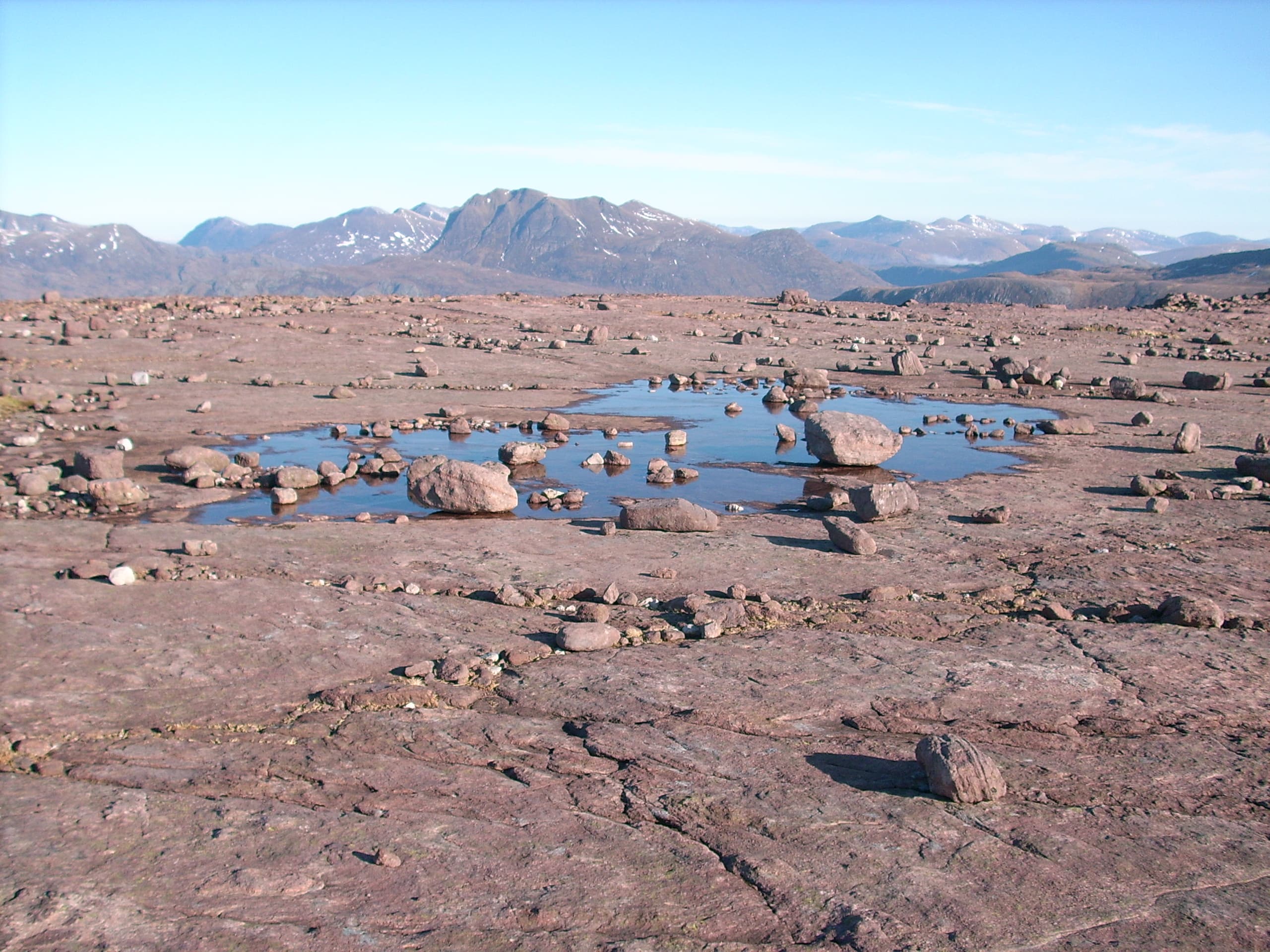
A flat-topped Torridonian Graham north of Loch Maree, famous for the bright white quartzite paving stones that cover its summit. The view across to Slioch and Beinn Eighe is one of the finest in the area.
Quick facts
- Height
- 725.4m/ 2380ft
- Prominence
- 368 m
- Distance
- 13 km
- Ascent
- 594 m
- Time
- 4–6 hrs
- Grid ref
- NG931637
- Parking
- NG929620
- Nearest
- Ullapool· Inverness 76km
- Dogs
- Dogs on lead required near livestockDog-friendly guide ↗
Height and prominence cross-checked against the Database of British and Irish Hills (CC BY).
No GPX track yet
Walked this route? Share your track to help other walkers.
Standard route
loch-side path 20% · heather hillside 45% · rocky slopes 25% · summit area 10%
Park near Grudie Bridge on the A832. Cross the bridge and take the path west along the Abhainn an Fhasaigh, then climb the south-east spur to the quartzite plateau. The summit cairn sits at the western end of the slabs.
Terrain
Good path for the lower section, then heather and rocky terraces. The summit plateau is a remarkable sheet of weathered quartzite — like a natural pavement.
In winter
The quartzite plateau ices over and walking it in snow disguises which way the next terrace drops. Torridon SAIS region applies — the corries on the north side hold real avalanche risk.
This hill is in the Torridon SAIS forecast area. Check SAIS forecasts in winter (December–April).
Best time of year
Getting there
- Glasgow4h 1m
- Edinburgh4h 27m
OS maps: OS Landranger 19
Mobile signal: No signal in this stretch of Glen Torridon
Current conditions
Daylight Today
- Sunrise
- 04:42
- Sunset
- 22:13
- Civil dawn
- 03:38
- Civil dusk
- 23:17
NOAA Solar Calculator · 13 July 2026
Pair with
Curated multi-hill combinations from Beinn a' Chearcaill.
Around Beinn a' Chearcaill on the SCOT network
Getting there, basing yourself, and what to do off the hill.
Beinn a' Chearcaill — common questions
- How hard is Beinn a' Chearcaill?
- We grade Beinn a' Chearcaill at 4/5, which puts it in challenging territory. The usual route is around 13km with 594m of climbing; allow 4-6 hours. Underfoot: Good path for the lower section, then heather and rocky terraces.
- What is Beinn a' Chearcaill's prominence?
- 368m of prominence. That's the vertical drop from the summit to the col that links Beinn a' Chearcaill to the next higher ground.
- Where do I park for Beinn a' Chearcaill?
- Most walkers start from NG929620 near Ullapool. Verify the grid reference on an OS map before you set off — space is tight on busy summer weekends.
- When is the best time to climb Beinn a' Chearcaill?
- May, June, July, August, September give the most reliable conditions on Beinn a' Chearcaill. Beyond that window the high ground turns wintry: carry full mountain kit, be confident navigating, and check the SAIS avalanche forecast for the area.
- Is Beinn a' Chearcaill dog-friendly?
- Yes, but dogs must be kept on a lead — there is livestock or ground-nesting bird interest on the route.
- Is there mobile signal on Beinn a' Chearcaill?
- No signal in this stretch of Glen Torridon
- Is Beinn a' Chearcaill safe in winter?
- The quartzite plateau ices over and walking it in snow disguises which way the next terrace drops. Torridon SAIS region applies — the corries on the north side hold real avalanche risk.
Get the OutdoorSCOT weekly
One email a week — new route, hill and bothy guides, seasonal conditions and the odd hard-won lesson. No spam, unsubscribe in one click.