Graham · North-West Highlands
Beinn a' Mhuinidh
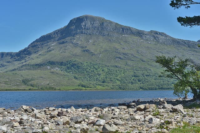
Beinn a' Mhuinidh (689m) is the mossy hill that overlooks the head of Loch Maree, set in the NH06 square at the edge of the Letterewe Forest. Its sandstone north face plunges 400m to the loch in the spectacular Waterfall Buttress, a venue for early Scottish rock pioneers. From the summit the view stretches across to Slioch and out west to An Teallach.
Quick facts
- Height
- 689.9m/ 2263ft
- Prominence
- 381 m
- Distance
- 13 km
- Ascent
- 565 m
- Time
- 4–6 hrs
- Grid ref
- NH032660
- Parking
- NH056690
- Nearest
- Ullapool· Inverness 67km
- Dogs
- Dogs on lead required near livestockDog-friendly guide ↗
Height and prominence cross-checked against the Database of British and Irish Hills (CC BY).
No GPX track yet
Walked this route? Share your track to help other walkers.
Standard route
heather moorland 55% · rocky hillside 30% · grassy slopes 15%
From the carpark at Incheril near Kinlochewe follow the Loch Maree shore path west for about 5km. At the foot of Waterfall Buttress strike up the broad heather flank to the east, gaining the south-east shoulder above the cliffs. A long heathery rise leads to the cairn on a cropped turf top.
Terrain
Loch-shore path on rough birch ground, then deep heather and bracken above 300m. The south-east shoulder is straightforward but steep, with one short slabby section easily turned. The summit plateau is firm cropped grass.
In winter
Wester Ross winters drive heavy wet snow against the north face of the hill and the Waterfall Buttress freezes into a major ice venue. The walker's south-east shoulder stays much more manageable but ice axe and crampons are essential above 500m. Atlantic squalls can pin a party on the summit in minutes.
This hill is in the Torridon SAIS forecast area. Check SAIS forecasts in winter (December–April).
Best time of year
Getting there
- Glasgow4h 0m
- Edinburgh4h 22m
OS maps: OS Landranger 19
Mobile signal: Minimal. Remote Letterewe/Loch Maree area; most networks barely reach.
Current conditions
Daylight Today
- Sunrise
- 04:41
- Sunset
- 22:13
- Civil dawn
- 03:37
- Civil dusk
- 23:17
NOAA Solar Calculator · 13 July 2026
Around Beinn a' Mhuinidh on the SCOT network
Getting there, basing yourself, and what to do off the hill.
Beinn a' Mhuinidh — common questions
- How hard is Beinn a' Mhuinidh?
- We grade Beinn a' Mhuinidh at 4/5, which puts it in challenging territory. The usual route is around 13km with 565m of climbing; allow 4-6 hours. Ground conditions: Loch-shore path on rough birch ground, then deep heather and bracken above 300m.
- How much drop does Beinn a' Mhuinidh have?
- The drop is 381m: measured from the summit of Beinn a' Mhuinidh down to the saddle joining it to higher terrain.
- Where's the parking for Beinn a' Mhuinidh?
- Park at NH056690 near Ullapool. Double-check the grid reference on an OS map first; informal laybys here fill early in high season.
- What's the best month to climb Beinn a' Mhuinidh?
- Aim for May, June, July, August, September on Beinn a' Mhuinidh. In the remaining months treat it as a winter hill — full kit, solid navigation, and a look at the relevant SAIS avalanche forecast before you go.
- Can dogs go up Beinn a' Mhuinidh?
- Dogs are fine on a lead. The route passes livestock or ground-nesting bird habitat, so keep them close throughout.
- Will I get phone signal on Beinn a' Mhuinidh?
- Minimal. Remote Letterewe/Loch Maree area; most networks barely reach.
- Is Beinn a' Mhuinidh safe in winter?
- Wester Ross winters drive heavy wet snow against the north face of the hill and the Waterfall Buttress freezes into a major ice venue. The walker's south-east shoulder stays much more manageable but ice axe and crampons are essential above 500m. Atlantic squalls can pin a party on the summit in minutes.
Get the OutdoorSCOT weekly
One email a week — new route, hill and bothy guides, seasonal conditions and the odd hard-won lesson. No spam, unsubscribe in one click.