Munro · North-West Highlands
Beinn Tarsuinn
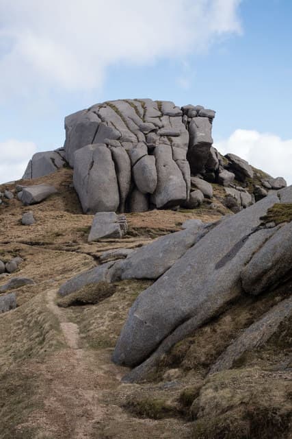
Beinn Tarsuinn (933m) — "transverse hill" — is one of the Fisherfield Six Munros, sitting deep within the Fisherfield Forest wilderness on the long ridge between Mullach Coire Mhic Fhearchair and A' Mhaighdean. The summit area is famous for the "Table" — a flat grassy area at the high point that gives the hill its distinctive horizontal profile. The view from the summit ridge across to An Teallach is one of the great Northern Highlands panoramas.
Quick facts
- Height
- 933.8m/ 3064ft
- Prominence
- 207 m
- Distance
- 16 km
- Ascent
- 822 m
- Time
- 6–9 hrs
- Grid ref
- NH039727
- Parking
- NH114859
- Nearest
- Ullapool· Inverness 68km
- Dogs
- Dogs on lead required near livestockDog-friendly guide ↗
Height and prominence cross-checked against the Database of British and Irish Hills (CC BY).
No GPX track yet
Walked this route? Share your track to help other walkers.
Standard route
Remote approach path 40% · Open hillside 30% · Narrow summit ridge 30%
See Mullach Coire Mhic Fhearchair for the full Fisherfield Six round from Corrie Hallie via Shenavall bothy. Beinn Tarsuinn is the third Munro reached on the standard round — climbed from Mullach Coire Mhic Fhearchair via the broad connecting ridge. The summit "Table" provides a unique flat resting place at the high point. Continue west to A' Mhaighdean and Ruadh Stac Mòr. The full Fisherfield round runs about 50km with 2500m of ascent — typically tackled over two days.
Terrain
Beinn Tarsuinn's summit ridge is famous for the flat grassy "Table" — a unique level platform at the high point. The connecting ridges across the Fisherfield Six involve significant up-and-down between summits, particularly the descent from the Table westwards. Paths are largely absent throughout the Fisherfield wilderness; navigation skills essential.
In winter
A serious wilderness winter day. The Table area drifts heavily with wind-blown snow. Cornicing on the north margins of the summit ridge is consistent. The Fisherfield approach in winter is committing — most parties spread the round over multiple days. There is no rescue infrastructure within reach. SAIS Northern Highlands applies. Mobile reception absent throughout.
This hill is in the Torridon SAIS forecast area. Check SAIS forecasts in winter (December–April).
Best time of year
Getting there
- Glasgow4h 7m
- Edinburgh4h 29m
OS maps: OS Landranger 19
Mobile signal: No signal in Fisherfield. Download maps at home before this remote expedition.
Current conditions
Daylight Today
- Sunrise
- 04:58
- Sunset
- 21:58
- Civil dawn
- 04:00
- Civil dusk
- 22:56
NOAA Solar Calculator · 23 July 2026
Pair with
Curated multi-hill combinations from Beinn Tarsuinn.
Around Beinn Tarsuinn on the SCOT network
Getting there, basing yourself, and what to do off the hill.
Beinn Tarsuinn — common questions
- How hard is Beinn Tarsuinn?
- We grade Beinn Tarsuinn at 5/5, which puts it in very challenging territory. The usual route is around 16km with 822m of climbing; allow 6-9 hours. Underfoot: Beinn Tarsuinn's summit ridge is famous for the flat grassy "Table" — a unique level platform at the high point.
- What is Beinn Tarsuinn's prominence?
- 207m of prominence. That's the vertical drop from the summit to the col that links Beinn Tarsuinn to the next higher ground.
- Where do I park for Beinn Tarsuinn?
- Most walkers start from NH114859 near Ullapool. Verify the grid reference on an OS map before you set off — space is tight on busy summer weekends.
- When is the best time to climb Beinn Tarsuinn?
- May, June, July, August, September give the most reliable conditions on Beinn Tarsuinn. Beyond that window the high ground turns wintry: carry full mountain kit, be confident navigating, and check the SAIS avalanche forecast for the area.
- Is Beinn Tarsuinn dog-friendly?
- Yes, but dogs must be kept on a lead — there is livestock or ground-nesting bird interest on the route.
- Is there mobile signal on Beinn Tarsuinn?
- No signal in Fisherfield. Download maps at home before this remote expedition.
- Is Beinn Tarsuinn safe in winter?
- A serious wilderness winter day. The Table area drifts heavily with wind-blown snow. Cornicing on the north margins of the summit ridge is consistent. The Fisherfield approach in winter is committing — most parties spread the round over multiple days. There is no rescue infrastructure within reach. SAIS Northern Highlands applies. Mobile reception absent throughout.
Get the OutdoorSCOT weekly
One email a week — new route, hill and bothy guides, seasonal conditions and the odd hard-won lesson. No spam, unsubscribe in one click.