Corbett · North-West Highlands
Beinn a' Chlaidheimh
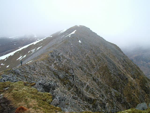
Beinn a' Chlaidheimh — "the hill of the sword" — sits at the northern end of the great Fisherfield horseshoe, looking out across the Strath na Sealga flats to An Teallach. For decades it stood as the most remote Munro on the mainland at a recorded 916m, until a 2011 survey trimmed it to 913m and it dropped back into the Corbett list — much to the irritation of those who had already counted it. Whatever its classification it remains a magnificent summit in some of the wildest country in Scotland.
Quick facts
- Height
- 913.96m/ 2999ft
- Prominence
- 268 m
- Distance
- 16 km
- Ascent
- 803 m
- Time
- 6–9 hrs
- Grid ref
- NH061775
- Parking
- NH114851
- Nearest
- Ullapool· Inverness 68km
- Dogs
- Dogs on lead required near livestockDog-friendly guide ↗
Height and prominence cross-checked against the Database of British and Irish Hills (CC BY).
No GPX track yet
Walked this route? Share your track to help other walkers.
Standard route
rough path 20% · deep heather 40% · bog and grass 25% · rocky summit 15%
No short option exists. Most parties walk in from Corrie Hallie on the A832 south of Dundonnell on the Shenavall path — around 8km of stalkers track and rough moorland to the river at the head of Strath na Sealga, which usually needs to be forded. From the bothy a long pathless pull leads up the north ridge to the summit. Day trips total 30km plus; most baggers stay at Shenavall and tackle Beinn a' Chlaidheimh as part of the Fisherfield round. The 16km figure assumes the bothy as base.
Terrain
Classic Fisherfield ground — deep heather, peat hags and hidden burns on the approach, with a major unbridged river crossing of the Abhainn Strath na Sealga. The river can be impassable after rain and parties have been stranded for days. Above the bothy the ground turns to firm sandstone with quartzite caps, with occasional rocky steps on the north ridge. The connecting ridge south to Sgurr Ban involves a steep drop and re-ascent.
In winter
A serious winter proposition by any measure — the river crossing alone rules the hill out for much of November to March, when meltwater swells the Abhainn into a raging flood. Even in stable cold spells the position deep in Fisherfield means no quick exit and no phone signal. Most winter parties carry sleeping kit and bivvy or use Shenavall. Ice axe and crampons essential; full avalanche awareness on the steep north and east faces.
This hill is in the Torridon SAIS forecast area. Check SAIS forecasts in winter (December–April).
Best time of year
Getting there
- Glasgow4h 12m
- Edinburgh5h 32m
OS maps: OS Landranger 19
Mobile signal: No signal — deep in Fisherfield, one of Scotland's most remote areas
Current conditions
Daylight Today
- Sunrise
- 04:47
- Sunset
- 22:08
- Civil dawn
- 03:45
- Civil dusk
- 23:10
NOAA Solar Calculator · 17 July 2026
Pair with
Curated multi-hill combinations from Beinn a' Chlaidheimh.
Around Beinn a' Chlaidheimh on the SCOT network
Getting there, basing yourself, and what to do off the hill.
Beinn a' Chlaidheimh — common questions
- How hard is Beinn a' Chlaidheimh?
- We grade Beinn a' Chlaidheimh at 5/5, which puts it in very challenging territory. The usual route is around 16km with 803m of climbing; allow 6-9 hours. Underfoot: Classic Fisherfield ground — deep heather, peat hags and hidden burns on the approach, with a major unbridged river crossing of the Abhainn Strath na Sealga.
- What is Beinn a' Chlaidheimh's prominence?
- 268m of prominence. That's the vertical drop from the summit to the col that links Beinn a' Chlaidheimh to the next higher ground.
- Where do I park for Beinn a' Chlaidheimh?
- Most walkers start from NH114851 near Ullapool. Verify the grid reference on an OS map before you set off — space is tight on busy summer weekends.
- When is the best time to climb Beinn a' Chlaidheimh?
- May, June, July, August, September give the most reliable conditions on Beinn a' Chlaidheimh. Beyond that window the high ground turns wintry: carry full mountain kit, be confident navigating, and check the SAIS avalanche forecast for the area.
- Is Beinn a' Chlaidheimh dog-friendly?
- Yes, but dogs must be kept on a lead — there is livestock or ground-nesting bird interest on the route.
- Is there mobile signal on Beinn a' Chlaidheimh?
- No signal — deep in Fisherfield, one of Scotland's most remote areas
- Is Beinn a' Chlaidheimh safe in winter?
- A serious winter proposition by any measure — the river crossing alone rules the hill out for much of November to March, when meltwater swells the Abhainn into a raging flood. Even in stable cold spells the position deep in Fisherfield means no quick exit and no phone signal. Most winter parties carry sleeping kit and bivvy or use Shenavall. Ice axe and crampons essential; full avalanche awareness on the steep north and east faces.
Get the OutdoorSCOT weekly
One email a week — new route, hill and bothy guides, seasonal conditions and the odd hard-won lesson. No spam, unsubscribe in one click.