Corbett · North-West Highlands
Beinn Dearg Bheag
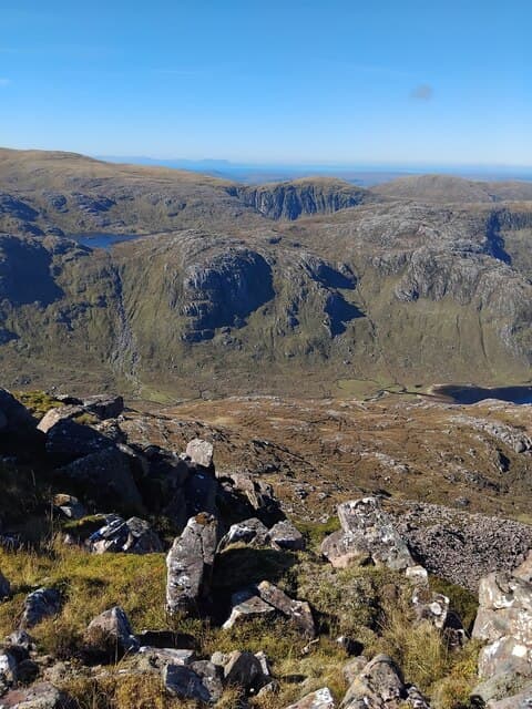
Beinn Dearg Bheag — "the little red hill" — is the smaller sister of Beinn Dearg Mor, set deep inside the Fisherfield Forest, the two hills sharing a high ridge above Shenavall bothy. At 817m the summit is a small cairn on a striking Torridonian sandstone top, the red colouring giving the hill its name. The position deep in Fisherfield, with An Teallach's ridges filling the western view, is among the finest in mainland Scotland. Almost always tackled together with Beinn Dearg Mor.
Gaelic: “mountain, red, small” · Pronunciation: bine jerr-ak vek
Quick facts
- Height
- 817.9m/ 2683ft
- Prominence
- 226 m
- Distance
- 15 km
- Ascent
- 719 m
- Time
- 5–8 hrs
- Grid ref
- NH019811
- Parking
- NH114851
- Nearest
- Ullapool· Inverness 74km
- Dogs
- Dogs on lead required near livestockDog-friendly guide ↗
Height and prominence cross-checked against the Database of British and Irish Hills (CC BY).
No GPX track yet
Walked this route? Share your track to help other walkers.
Standard route
Shenavall path 40% · river crossing 5% · sandstone ridge 40% · summit cone 15%
The standard expedition starts from Corrie Hallie on the A832 south of Dundonnell. Walk in to Shenavall bothy (around 8km) and ford the river — usually difficult after rain. From the bothy climb the south-east ridge over Beinn Dearg Mor first, then traverse north over the high col to Beinn Dearg Bheag. Total return day is 30km plus; the 15km/719m figures cover the hill alone from a Shenavall base.
Terrain
The Shenavall path is firm peat and quartzite for the approach but the river crossing of the Abhainn Strath na Sealga is unbridged and impassable in spate. The ridge between Beinn Dearg Mor and Bheag is sandstone blocks and short turf with one narrow section involving easy scrambling. The summit cone of Bheag is loose blocky red sandstone. No serious exposure but plenty of rough ground.
In winter
A genuine winter expedition rather than a day walk — the river crossing freezes unpredictably, the sandstone ridge develops cornices on the south side, and the absence of phone signal makes self-reliance total. Most parties carry bivvy kit or use Shenavall. The sandstone steps ice up readily; axe and crampons essential.
This hill is in the Torridon SAIS forecast area. Check SAIS forecasts in winter (December–April).
Best time of year
Getting there
- Glasgow4h 17m
- Edinburgh5h 38m
OS maps: OS Landranger 19
Mobile signal: No signal anywhere in the Fisherfield interior
Current conditions
Daylight Today
- Sunrise
- 04:47
- Sunset
- 22:08
- Civil dawn
- 03:45
- Civil dusk
- 23:10
NOAA Solar Calculator · 17 July 2026
Around Beinn Dearg Bheag on the SCOT network
Getting there, basing yourself, and what to do off the hill.
Beinn Dearg Bheag — common questions
- What difficulty is Beinn Dearg Bheag?
- On the OutdoorSCOT scale, Beinn Dearg Bheag comes in at 5/5 — very challenging. Expect roughly 15km and 719m of ascent on the usual route — 5-8 hours for most parties. Terrain: The Shenavall path is firm peat and quartzite for the approach but the river crossing of the Abhainn Strath na Sealga is unbridged and impassable in spate.
- How prominent is Beinn Dearg Bheag?
- Beinn Dearg Bheag has 226m of topographic prominence — the height of its summit above the highest col connecting it to higher ground.
- Where should I park to climb Beinn Dearg Bheag?
- Standard parking is at NH114851 near Ullapool. Check the parking grid reference on an OS map before travel; informal laybys can fill on summer weekends.
- When should I climb Beinn Dearg Bheag?
- The standard good-weather months for Beinn Dearg Bheag are May, June, July, August, September. Outside those months, expect winter conditions on the high ground — full mountain kit, navigation skills, and a check of the SAIS avalanche forecast for the relevant region.
- Can I bring my dog up Beinn Dearg Bheag?
- On a lead only — the route crosses ground with livestock or nesting-bird interest.
- What's mobile reception like on Beinn Dearg Bheag?
- No signal anywhere in the Fisherfield interior
- Is Beinn Dearg Bheag safe in winter?
- A genuine winter expedition rather than a day walk — the river crossing freezes unpredictably, the sandstone ridge develops cornices on the south side, and the absence of phone signal makes self-reliance total. Most parties carry bivvy kit or use Shenavall. The sandstone steps ice up readily; axe and crampons essential.
Get the OutdoorSCOT weekly
One email a week — new route, hill and bothy guides, seasonal conditions and the odd hard-won lesson. No spam, unsubscribe in one click.