Corbett · North-West Highlands
Sail Mhor
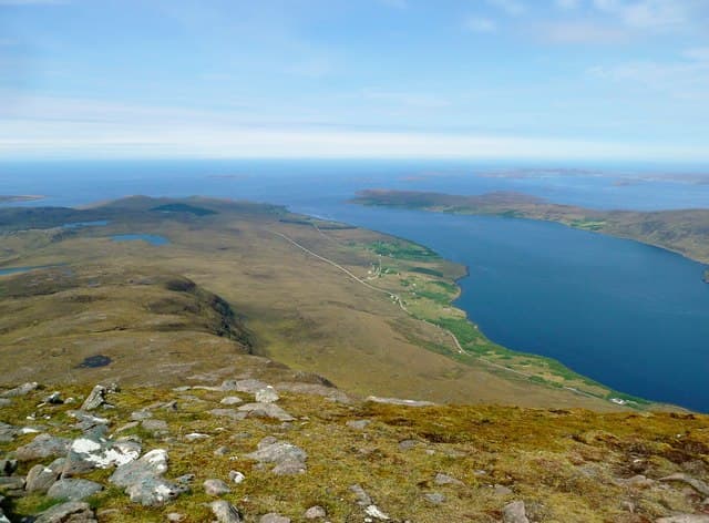
Sail Mhòr — 'the big heel' — is the 767m sandstone Corbett standing immediately west of An Teallach above Little Loch Broom. The mountain is in many ways An Teallach's outlying buttress: the same Torridonian sandstone, the same dramatic ridge architecture, just on a smaller scale. The west face plunges into Coire na Feòla in dramatic cliffs; the north ridge gives a fine summit approach with continuous views across to An Teallach's pinnacles. A useful follow-up summit for parties who have already bagged An Teallach.
Gaelic: “big” · Pronunciation: sail vore
Quick facts
- Height
- 766.2m/ 2514ft
- Prominence
- 321 m
- Distance
- 10 km
- Ascent
- 800 m
- Time
- 3–5 hrs
- Grid ref
- NH032887
- Parking
- NH050897
- Nearest
- Ullapool· Inverness 77km
- Dogs
- Dogs on lead required near livestockDog-friendly guide ↗
Height and prominence cross-checked against the Database of British and Irish Hills (CC BY).
No GPX track yet
Walked this route? Share your track to help other walkers.
Standard route
glen path 20% · steep heather 35% · rocky ridge 35% · summit rocks 10%
Park at the Ardessie falls layby on the A832 (NH050897), about 3km north-west of the Dundonnell Hotel. Follow the path up the south side of the Allt Airdeasaidh, climbing past the spectacular falls and into Coire an Eich. From the corrie, climb south-west onto Sail Mhòr's north ridge and follow it to the summit cairn. Return reverses the line. Allow 5–6 hours.
Terrain
Excellent path past Ardessie Falls — among the more impressive cascades in Wester Ross. The corrie above is rough heather and grass; higher up, the route crosses sound Torridonian sandstone, with the west side dropping sharply into Coire na Feòla. The summit cairn sits on a small rocky outcrop.
In winter
In winter Sail Mhòr's sandstone ridge ices up readily and the west-face drops become serious. The Ardessie path freezes hard, especially around the falls. Atlantic systems coming up Little Loch Broom deliver punishing weather. In firm conditions a striking short winter day with An Teallach as a backdrop.
This hill is in the Torridon SAIS forecast area. Check SAIS forecasts in winter (December–April).
Best time of year
Getting there
- Glasgow4h 25m
- Edinburgh5h 45m
OS maps: OS Landranger 19
Mobile signal: No signal in the remote Fisherfield/Braemore area
Current conditions
Daylight Today
- Sunrise
- 04:40
- Sunset
- 22:14
- Civil dawn
- 03:34
- Civil dusk
- 23:20
NOAA Solar Calculator · 13 July 2026
Pair with
Curated multi-hill combinations from Sail Mhor.
Around Sail Mhor on the SCOT network
Getting there, basing yourself, and what to do off the hill.
Sail Mhor — common questions
- What difficulty is Sail Mhor?
- On the OutdoorSCOT scale, Sail Mhor comes in at 3/5 — moderately challenging. Expect roughly 10km and 800m of ascent on the usual route — 3-5 hours for most parties. Ground conditions: Excellent path past Ardessie Falls — among the more impressive cascades in Wester Ross.
- How much drop does Sail Mhor have?
- The drop is 321m: measured from the summit of Sail Mhor down to the saddle joining it to higher terrain.
- Where's the parking for Sail Mhor?
- Park at NH050897 near Ullapool. Double-check the grid reference on an OS map first; informal laybys here fill early in high season.
- What's the best month to climb Sail Mhor?
- Aim for May, June, July, August, September on Sail Mhor. In the remaining months treat it as a winter hill — full kit, solid navigation, and a look at the relevant SAIS avalanche forecast before you go.
- Can dogs go up Sail Mhor?
- Dogs are fine on a lead. The route passes livestock or ground-nesting bird habitat, so keep them close throughout.
- Will I get phone signal on Sail Mhor?
- No signal in the remote Fisherfield/Braemore area
- Is Sail Mhor safe in winter?
- In winter Sail Mhòr's sandstone ridge ices up readily and the west-face drops become serious. The Ardessie path freezes hard, especially around the falls. Atlantic systems coming up Little Loch Broom deliver punishing weather. In firm conditions a striking short winter day with An Teallach as a backdrop.
Get the OutdoorSCOT weekly
One email a week — new route, hill and bothy guides, seasonal conditions and the odd hard-won lesson. No spam, unsubscribe in one click.