Graham · North-West Highlands
Beinn Ghobhlach
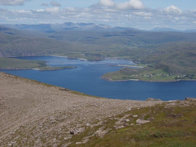
Beinn Ghobhlach (634m), the forked peak, dominates the Scoraig peninsula in the NH05 square between Little Loch Broom and Loch Broom itself. The twin tops of Torridonian sandstone give the hill its name and a strikingly sea-girt feel, with the Summer Isles, An Teallach and the open Minch in view from the cairn. The walk-in from Badrallach makes it one of the most maritime Grahams in the country.
Quick facts
- Height
- 634.9m/ 2083ft
- Prominence
- 401 m
- Distance
- 12 km
- Ascent
- 476 m
- Time
- 3–6 hrs
- Grid ref
- NH055943
- Parking
- NH100919
- Nearest
- Ullapool· Inverness 78km
- Dogs
- Dogs on lead required near livestockDog-friendly guide ↗
Height and prominence cross-checked against the Database of British and Irish Hills (CC BY).
No GPX track yet
Walked this route? Share your track to help other walkers.
Standard route
rocky ridge 40% · heather moorland 40% · grass and bilberry 20%
Start from the small car park at NH100919 above Badrallach and follow the postal track west before turning south up the eastern shoulder. The lower ground is heather and runnels; higher up a faint trod climbs onto the sandstone benches that lead to the eastern top. A short rocky drop to the col and re-climb gives the western, slightly lower top. About six hours round trip — the views back to An Teallach are the real reward.
Terrain
Boggy heather on the approach gives way to terraced sandstone shelves on the upper hill. The notch between the two tops involves a brief hands-on scramble — easy enough in summer but exposed in wind. Off the ridge the sandstone drops in tiers, so keep close to the crest.
In winter
The peninsula catches every Atlantic front and Beinn Ghobhlach can hold ice on the sandstone shelves long after the surrounding moor has thawed. The notch between the tops becomes serious when verglassed and an axe is needed for the short re-climb. Approach via Badrallach is exposed to north-westerlies, so check wind forecasts as well as freezing levels.
This hill is in the Torridon SAIS forecast area. Check SAIS forecasts in winter (December–April).
Best time of year
Getting there
- Glasgow5h 31m
- Edinburgh5h 49m
OS maps: OS Landranger 19
Mobile signal: Poor. Remote Coigach/Little Loch Broom; coverage here is marginal.
Current conditions
Daylight Today
- Sunrise
- 04:46
- Sunset
- 22:09
- Civil dawn
- 03:43
- Civil dusk
- 23:12
NOAA Solar Calculator · 17 July 2026
Around Beinn Ghobhlach on the SCOT network
Getting there, basing yourself, and what to do off the hill.
Beinn Ghobhlach — common questions
- How hard is Beinn Ghobhlach?
- We grade Beinn Ghobhlach at 4/5, which puts it in challenging territory. The usual route is around 12km with 476m of climbing; allow 3-6 hours. Underfoot: Boggy heather on the approach gives way to terraced sandstone shelves on the upper hill.
- What is Beinn Ghobhlach's prominence?
- 401m of prominence. That's the vertical drop from the summit to the col that links Beinn Ghobhlach to the next higher ground.
- Where do I park for Beinn Ghobhlach?
- Most walkers start from NH100919 near Ullapool. Verify the grid reference on an OS map before you set off — space is tight on busy summer weekends.
- When is the best time to climb Beinn Ghobhlach?
- May, June, July, August, September give the most reliable conditions on Beinn Ghobhlach. Beyond that window the high ground turns wintry: carry full mountain kit, be confident navigating, and check the SAIS avalanche forecast for the area.
- Is Beinn Ghobhlach dog-friendly?
- Yes, but dogs must be kept on a lead — there is livestock or ground-nesting bird interest on the route.
- Is there mobile signal on Beinn Ghobhlach?
- Poor. Remote Coigach/Little Loch Broom; coverage here is marginal.
- Is Beinn Ghobhlach safe in winter?
- The peninsula catches every Atlantic front and Beinn Ghobhlach can hold ice on the sandstone shelves long after the surrounding moor has thawed. The notch between the tops becomes serious when verglassed and an axe is needed for the short re-climb. Approach via Badrallach is exposed to north-westerlies, so check wind forecasts as well as freezing levels.
Get the OutdoorSCOT weekly
One email a week — new route, hill and bothy guides, seasonal conditions and the odd hard-won lesson. No spam, unsubscribe in one click.