Graham · North-West Highlands
Ben More Coigach (Beinn Mhor na Coigich)
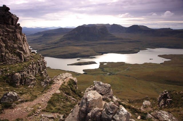
The bulky parent peak of the Coigach group, rising in a sweep of sandstone terraces straight from the sea at Achiltibuie. The summit windshelter sits at the western end of a long ridge that stretches to Sgurr an Fhidhleir's celebrated nose — one of the finest mountain edges in the north-west.
Gaelic: “mountain, big, of the” · Pronunciation: ben more coigach (beinn vore na coigich)
Quick facts
- Height
- 743.4m/ 2439ft
- Prominence
- 655 m
- Distance
- 14 km
- Ascent
- 609 m
- Time
- 4–7 hrs
- Grid ref
- NC093042
- Parking
- NC065039
- Nearest
- Ullapool· Inverness 82km
- Dogs
- Dogs on lead required near livestockDog-friendly guide ↗
Height and prominence cross-checked against the Database of British and Irish Hills (CC BY).
No GPX track yet
Walked this route? Share your track to help other walkers.
Standard route
coastal path 15% · rough heather 25% · rocky ridge 45% · summit area 15%
From the houses at Culnacraig follow the coast path east briefly before turning up the steep grassy and rocky south flank. Above the terraces a faint line follows the ridge crest north-east to the windshelter, with the Fiddler at the far end of the day.
Terrain
Boggy approach, then a long pull on rocky terraces and sandstone slabs. The ridge above gives mostly easy walking with one or two narrow rocky steps.
In winter
Coastal but high-quality winter conditions can build on the north-facing terraces above Lochan Tuath, with verglas on the sandstone slabs being the deciding factor. Atlantic winds sweep the ridge clear of snow yet plaster it with rime.
This hill is in the Torridon SAIS forecast area. Check SAIS forecasts in winter (December–April).
Best time of year
Getting there
- Glasgow5h 41m
- Edinburgh5h 57m
OS maps: OS Landranger 15
Mobile signal: No signal in Coigach area; possible brief signal with Ullapool visible to the south
Current conditions
Daylight Today
- Sunrise
- 04:45
- Sunset
- 22:09
- Civil dawn
- 03:42
- Civil dusk
- 23:13
NOAA Solar Calculator · 17 July 2026
Pair with
Curated multi-hill combinations from Ben More Coigach (Beinn Mhor na Coigich).
Got a photo of Ben More Coigach (Beinn Mhor na Coigich)?
30 seconds, helps other walkers.
Submit a photoAround Ben More Coigach (Beinn Mhor na Coigich) on the SCOT network
Getting there, basing yourself, and what to do off the hill.
Ben More Coigach (Beinn Mhor na Coigich) — common questions
- Is Ben More Coigach (Beinn Mhor na Coigich) a hard climb?
- Ben More Coigach (Beinn Mhor na Coigich) is rated 4/5 (challenging) on the OutdoorSCOT scale. The standard route covers about 14km with 609m of ascent and takes most walkers 4-7 hours. Underfoot: Boggy approach, then a long pull on rocky terraces and sandstone slabs.
- What is Ben More Coigach (Beinn Mhor na Coigich)'s prominence?
- 655m of prominence. That's the vertical drop from the summit to the col that links Ben More Coigach (Beinn Mhor na Coigich) to the next higher ground.
- Where do I park for Ben More Coigach (Beinn Mhor na Coigich)?
- Most walkers start from NC065039 near Ullapool. Verify the grid reference on an OS map before you set off — space is tight on busy summer weekends.
- When is the best time to climb Ben More Coigach (Beinn Mhor na Coigich)?
- May, June, July, August, September give the most reliable conditions on Ben More Coigach (Beinn Mhor na Coigich). Beyond that window the high ground turns wintry: carry full mountain kit, be confident navigating, and check the SAIS avalanche forecast for the area.
- Is Ben More Coigach (Beinn Mhor na Coigich) dog-friendly?
- Yes, but dogs must be kept on a lead — there is livestock or ground-nesting bird interest on the route.
- Is there mobile signal on Ben More Coigach (Beinn Mhor na Coigich)?
- No signal in Coigach area; possible brief signal with Ullapool visible to the south
- Is Ben More Coigach (Beinn Mhor na Coigich) safe in winter?
- Coastal but high-quality winter conditions can build on the north-facing terraces above Lochan Tuath, with verglas on the sandstone slabs being the deciding factor. Atlantic winds sweep the ridge clear of snow yet plaster it with rime.
Get the OutdoorSCOT weekly
One email a week — new route, hill and bothy guides, seasonal conditions and the odd hard-won lesson. No spam, unsubscribe in one click.