Corbett · North-West Highlands
Cul Beag
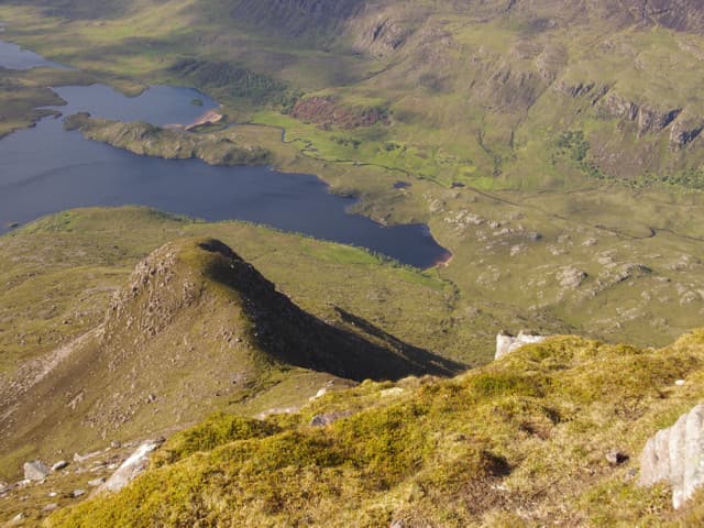
Cul Beag is the smaller, steeper neighbour of Cul Mor in the Coigach hills, sitting south of Stac Pollaidh on the road from Drumrunie to Lochinver. The mountain is built of Torridonian sandstone and rises straight from Loch Lurgainn in a single dramatic line — short on metres, big on character. From the summit you look straight across to Stac Pollaidh's pinnacles and out over Suilven, Quinag and the rest of Assynt. Short by Corbett standards but steep enough to feel like a proper hill day.
Gaelic: “small” · Pronunciation: cul bek
Quick facts
- Height
- 769.4m/ 2524ft
- Prominence
- 546 m
- Distance
- 9 km
- Ascent
- 740 m
- Time
- 3–5 hrs
- Grid ref
- NC140088
- Parking
- NC141072
- Nearest
- Ullapool· Inverness 82km
- Dogs
- Dogs on lead required near livestockDog-friendly guide ↗
Height and prominence cross-checked against the Database of British and Irish Hills (CC BY).
No GPX track yet
Walked this route? Share your track to help other walkers.
Standard route
moorland path 20% · rough heather 30% · sandstone ridge 35% · summit area 15%
The standard route starts from a layby on the Drumrunie–Achiltibuie road (A835/the single-track road west) below the Linneraineach plantation. A vague path heads south-east across moorland and climbs steeply onto the broad south ridge. From the south top the ridge narrows briefly before opening onto the summit plateau. Return by the same line, or descend north-west into Coir' an Lochain Sgeireach for a circuit (rough). Allow 4–5 hours.
Terrain
Short, sharp and rough underfoot. The lower moorland is wet and trackless; the steep central section is on grass with rocky steps; the summit ridge is sandstone slab. In any wet weather the slabs are slippery — care needed on descent.
In winter
Cul Beag's steep upper slopes hold snow longer than the elevation suggests because of the aspect, and the summit slabs ice up readily. The descent line is committing in poor visibility. A small but serious winter hill — full kit required if snow lies.
This hill is in the Torridon SAIS forecast area. Check SAIS forecasts in winter (December–April).
Best time of year
Getting there
- Glasgow5h 45m
- Edinburgh5h 0m
OS maps: OS Landranger 15
Mobile signal: No signal in the Coigach interior; intermittent EE on the A835 at Drumrunie
Current conditions
Daylight Today
- Sunrise
- 04:37
- Sunset
- 22:15
- Civil dawn
- 03:31
- Civil dusk
- 23:21
NOAA Solar Calculator · 13 July 2026
Pair with
Curated multi-hill combinations from Cul Beag.
Around Cul Beag on the SCOT network
Getting there, basing yourself, and what to do off the hill.
Cul Beag — common questions
- How difficult is Cul Beag?
- Cul Beag carries a 3/5 (moderately challenging) grade on the OutdoorSCOT scale. Count on about 9km, 740m of ascent and a 3-5 hour day on the standard route. Terrain: Short, sharp and rough underfoot.
- How prominent is Cul Beag?
- Cul Beag has 546m of topographic prominence — the height of its summit above the highest col connecting it to higher ground.
- Where should I park to climb Cul Beag?
- Standard parking is at NC141072 near Ullapool. Check the parking grid reference on an OS map before travel; informal laybys can fill on summer weekends.
- When should I climb Cul Beag?
- The standard good-weather months for Cul Beag are May, June, July, August, September. Outside those months, expect winter conditions on the high ground — full mountain kit, navigation skills, and a check of the SAIS avalanche forecast for the relevant region.
- Can I bring my dog up Cul Beag?
- On a lead only — the route crosses ground with livestock or nesting-bird interest.
- What's mobile reception like on Cul Beag?
- No signal in the Coigach interior; intermittent EE on the A835 at Drumrunie
- Is Cul Beag safe in winter?
- Cul Beag's steep upper slopes hold snow longer than the elevation suggests because of the aspect, and the summit slabs ice up readily. The descent line is committing in poor visibility. A small but serious winter hill — full kit required if snow lies.
Get the OutdoorSCOT weekly
One email a week — new route, hill and bothy guides, seasonal conditions and the odd hard-won lesson. No spam, unsubscribe in one click.