Graham · North-West Highlands
Sgurr an Fhidhleir
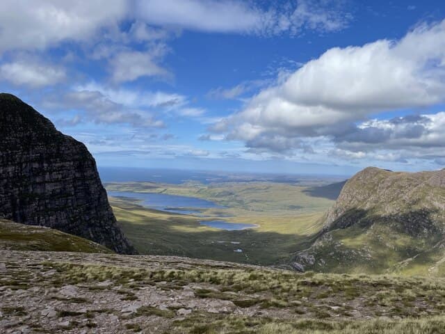
Sgurr an Fhidhleir (703m) — the Fiddler — at NC09 in Coigach is one of the most photographed peaks in the North-West, a sheer Torridonian sandstone prow rising above Loch Lurgainn opposite Stac Pollaidh. The cairned summit perches at the very edge of the 200m precipice that gives the hill its dramatic profile from the road. To stand on the lip and look down the great Fiddler's Nose is among the most exhilarating positions of any Scottish Graham.
Quick facts
- Height
- 703.9m/ 2309ft
- Prominence
- 160 m
- Distance
- 13 km
- Ascent
- 576 m
- Time
- 4–6 hrs
- Grid ref
- NC094054
- Parking
- NC097049
- Nearest
- Ullapool· Inverness 83km
- Dogs
- Dogs on lead required near livestockDog-friendly guide ↗
Height and prominence cross-checked against the Database of British and Irish Hills (CC BY).
No GPX track yet
Walked this route? Share your track to help other walkers.
Standard route
rocky scramble 35% · heather moorland 40% · grassy ledges 25%
From the parking by Loch Lurgainn at NC097049, take the well-worn path north through bog and rocky bluffs onto Sgurr an Fhidhleir's south-east shoulder. The summit is gained by climbing the back slope — the prow itself is rock-climbing territory only. Most walkers continue onto neighbouring Beinn an Eoin via the connecting ridge. 13km circuit, 576m climbed.
Terrain
Boggy lower path improves as height is gained. Sandstone slabs and rock bands break the upper south-east shoulder but a careful line keeps the route at walking grade. The summit edge is unfenced and absolutely vertical — keep well back in wind or cloud. Children should be on a short rein.
In winter
The Fiddler in winter is a serious objective even from the back. Sandstone slabs glaze quickly after thaw-refreeze and the prow accumulates massive cornices in any westerly storm. SAIS Northern Highlands forecasts Coigach indirectly. December daylight at this latitude drops below seven hours; start at first light.
This hill is in the Torridon SAIS forecast area. Check SAIS forecasts in winter (December–April).
Best time of year
Getting there
- Glasgow5h 42m
- Edinburgh5h 58m
OS maps: OS Landranger 15
Mobile signal: Very poor. Remote Coigach peninsula; no reliable signal on any network.
Current conditions
Daylight Today
- Sunrise
- 04:38
- Sunset
- 22:15
- Civil dawn
- 03:32
- Civil dusk
- 23:21
NOAA Solar Calculator · 13 July 2026
Pair with
Curated multi-hill combinations from Sgurr an Fhidhleir.
Around Sgurr an Fhidhleir on the SCOT network
Getting there, basing yourself, and what to do off the hill.
Sgurr an Fhidhleir — common questions
- How hard is Sgurr an Fhidhleir?
- We grade Sgurr an Fhidhleir at 4/5, which puts it in challenging territory. The usual route is around 13km with 576m of climbing; allow 4-6 hours. Terrain: Boggy lower path improves as height is gained.
- How prominent is Sgurr an Fhidhleir?
- Sgurr an Fhidhleir has 160m of topographic prominence — the height of its summit above the highest col connecting it to higher ground.
- Where should I park to climb Sgurr an Fhidhleir?
- Standard parking is at NC097049 near Ullapool. Check the parking grid reference on an OS map before travel; informal laybys can fill on summer weekends.
- When should I climb Sgurr an Fhidhleir?
- The standard good-weather months for Sgurr an Fhidhleir are May, June, July, August, September. Outside those months, expect winter conditions on the high ground — full mountain kit, navigation skills, and a check of the SAIS avalanche forecast for the relevant region.
- Can I bring my dog up Sgurr an Fhidhleir?
- On a lead only — the route crosses ground with livestock or nesting-bird interest.
- What's mobile reception like on Sgurr an Fhidhleir?
- Very poor. Remote Coigach peninsula; no reliable signal on any network.
- Is Sgurr an Fhidhleir safe in winter?
- The Fiddler in winter is a serious objective even from the back. Sandstone slabs glaze quickly after thaw-refreeze and the prow accumulates massive cornices in any westerly storm. SAIS Northern Highlands forecasts Coigach indirectly. December daylight at this latitude drops below seven hours; start at first light.
Get the OutdoorSCOT weekly
One email a week — new route, hill and bothy guides, seasonal conditions and the odd hard-won lesson. No spam, unsubscribe in one click.