Munro · North-West Highlands
An Teallach - Bidein a' Ghlas Thuill
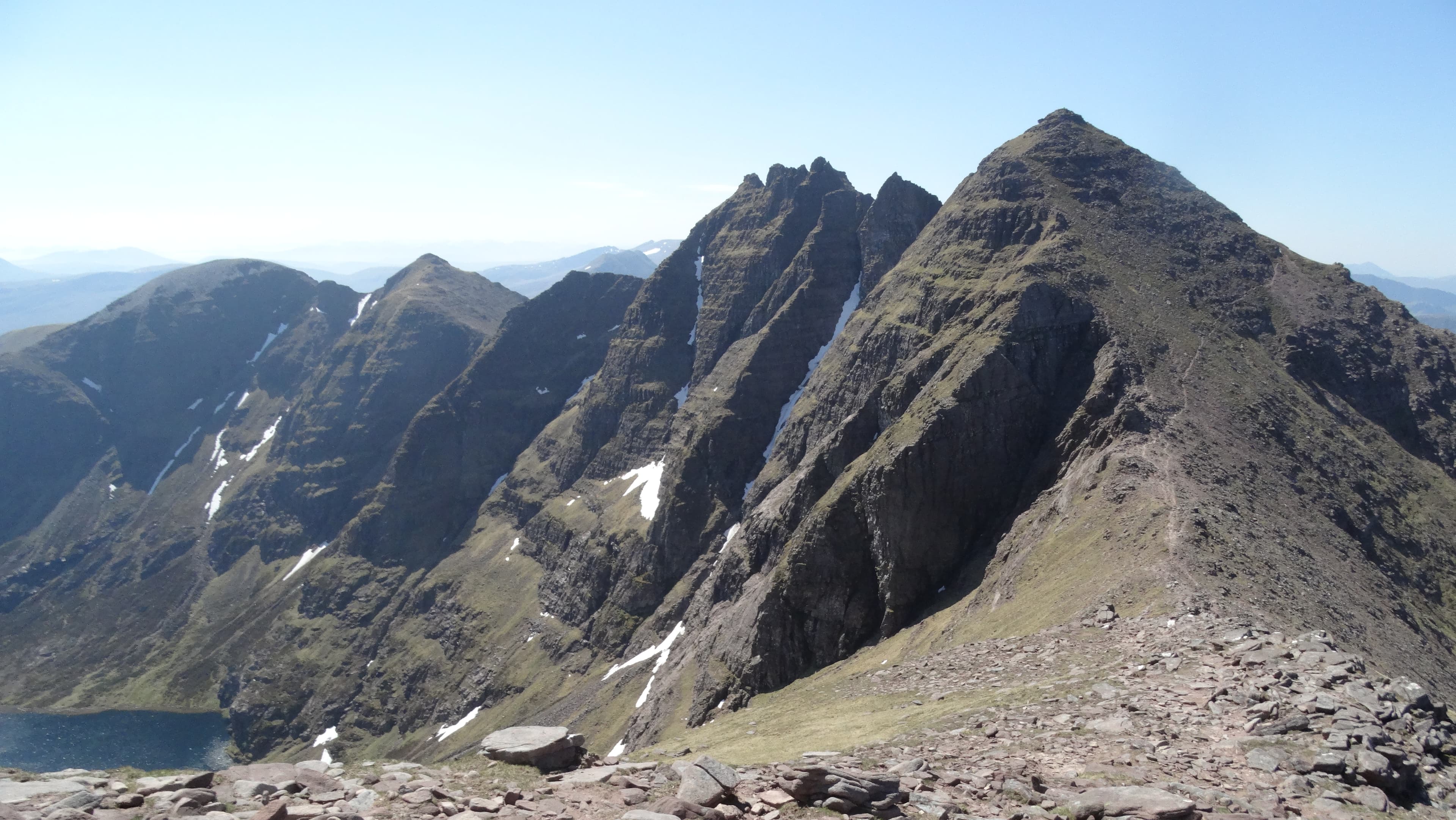
Bidein a' Ghlas Thuill (1062m) is the higher of the two Munro summits on An Teallach — "the forge" — one of the most spectacular mountains in Scotland. The peak crowns the north-east end of the famous pinnacled sandstone ridge above Loch Toll an Lochain, well inside the Northern Highlands. The full traverse takes in Bidein a' Ghlas Thuill, the second Munro Sgurr Fiona, and the celebrated Corrag Bhuidhe pinnacles — sustained Grade 2/3 scrambling that ranks among the very finest mountaineering days in Britain.
Gaelic: “the, pinnacle, of the, grey-green” · Pronunciation: an teallach bee-jen uh glass thuill
Quick facts
- Height
- 1062.6m/ 3486ft
- Prominence
- 757 m
- Distance
- 20 km
- Ascent
- 1415 m
- Time
- 9–10 hrs
- Grid ref
- NH068843
- Parking
- NH114859
- Nearest
- Ullapool· Inverness 71km
- Dogs
- Dogs on lead required near livestockDog-friendly guide ↗
Height and prominence cross-checked against the Database of British and Irish Hills (CC BY).
No GPX track yet
Walked this route? Share your track to help other walkers.
Standard route
Moorland path 25% · Steep hillside / rock 30% · Pinnacled ridge / scramble 45%
The classic line starts from the lay-by on the A832 at Dundonnell. Climb the steep stalkers' path into Coire a' Ghlas Thuill, the deep north-facing corrie. Bear left up the rocky scree-and-rock headwall onto the ridge, then north-west to Bidein a' Ghlas Thuill. Continue south along the ridge to Sgurr Fiona, then optionally over the Corrag Bhuidhe pinnacles or via the bypass path on the west side. Descend via the south-west ridge to Lord Berkeley's Seat and Sàil Liath, then back down to the road. Around 20km with 1415m of ascent for the full traverse.
Terrain
The stalkers' path into Coire a' Ghlas Thuill is well-built sandstone pitching for the lower section but becomes rough scree higher up. The corrie headwall is a sustained 200m of loose scree and broken sandstone slabs — slippery in the wet. The summit ridge is sandstone slabs and ribs with significant exposure on both sides. The Corrag Bhuidhe pinnacles are a sustained Grade 2/3 scramble on bare sandstone with airy moves; the western bypass is steep loose scree.
In winter
A major Scottish winter mountaineering objective. The Corrag Bhuidhe pinnacles in winter conditions become a serious technical mountaineering route (Grade III–IV). Even the standard summit ascent is committing in winter — corries hold huge avalanche-prone snow loads after westerly storms. The A832 at Dundonnell is gritted but the village is remote. Phone signal is absent on the hill. SAIS Northern Highlands applies. Full alpine kit and competence required.
This hill is in the Torridon SAIS forecast area. Check SAIS forecasts in winter (December–April).
Best time of year
Getting there
- Glasgow4h 19m
- Edinburgh5h 38m
OS maps: OS Landranger 19
Mobile signal: Moderate signal at Dundonnell on the A832. Coverage drops on the approach. No signal from about 400m upward. An Teallach is a very serious mountain — emergency communication planning essential.
Current conditions
Daylight Today
- Sunrise
- 04:57
- Sunset
- 21:58
- Civil dawn
- 03:59
- Civil dusk
- 22:56
NOAA Solar Calculator · 23 July 2026
Pair with
Curated multi-hill combinations from An Teallach - Bidein a' Ghlas Thuill.
Around An Teallach - Bidein a' Ghlas Thuill on the SCOT network
Getting there, basing yourself, and what to do off the hill.
An Teallach - Bidein a' Ghlas Thuill — common questions
- How hard is An Teallach - Bidein a' Ghlas Thuill?
- We grade An Teallach - Bidein a' Ghlas Thuill at 5/5, which puts it in very challenging territory. The usual route is around 20km with 1415m of climbing; allow 9-10 hours. Underfoot: The stalkers' path into Coire a' Ghlas Thuill is well-built sandstone pitching for the lower section but becomes rough scree higher up.
- What is An Teallach - Bidein a' Ghlas Thuill's prominence?
- 757m of prominence. That's the vertical drop from the summit to the col that links An Teallach - Bidein a' Ghlas Thuill to the next higher ground.
- Where do I park for An Teallach - Bidein a' Ghlas Thuill?
- Most walkers start from NH114859 near Ullapool. Verify the grid reference on an OS map before you set off — space is tight on busy summer weekends.
- When is the best time to climb An Teallach - Bidein a' Ghlas Thuill?
- May, June, July, August, September give the most reliable conditions on An Teallach - Bidein a' Ghlas Thuill. Beyond that window the high ground turns wintry: carry full mountain kit, be confident navigating, and check the SAIS avalanche forecast for the area.
- Is An Teallach - Bidein a' Ghlas Thuill dog-friendly?
- Yes, but dogs must be kept on a lead — there is livestock or ground-nesting bird interest on the route.
- Is there mobile signal on An Teallach - Bidein a' Ghlas Thuill?
- Moderate signal at Dundonnell on the A832. Coverage drops on the approach. No signal from about 400m upward. An Teallach is a very serious mountain — emergency communication planning essential.
- Is An Teallach - Bidein a' Ghlas Thuill safe in winter?
- A major Scottish winter mountaineering objective. The Corrag Bhuidhe pinnacles in winter conditions become a serious technical mountaineering route (Grade III–IV). Even the standard summit ascent is committing in winter — corries hold huge avalanche-prone snow loads after westerly storms. The A832 at Dundonnell is gritted but the village is remote. Phone signal is absent on the hill. SAIS Northern Highlands applies. Full alpine kit and competence required.
Get the OutdoorSCOT weekly
One email a week — new route, hill and bothy guides, seasonal conditions and the odd hard-won lesson. No spam, unsubscribe in one click.