Corbett · North-West Highlands
Cùl Mòr
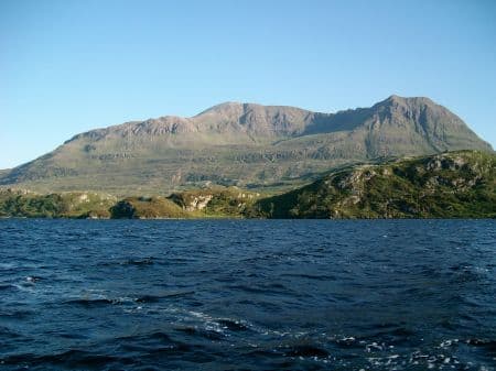
Cùl Mòr is the great twin-summited Corbett of Coigach, rising at the heart of the Inverpolly National Nature Reserve between Stac Pollaidh and Suilven. The 849m sandstone giant has two distinct tops — Creag nan Calman (the slightly higher) and Meallan Diomhain — separated by a small col, and the view unfolding from the summit is the picture-postcard panorama of north-west Scotland: Suilven's whaleback to the north, Stac Pollaidh's pinnacles to the west, Quinag to the north-east and the Summer Isles strewn across the Minch. A serious day across some of the roughest approach terrain in mainland Britain.
Gaelic: “big” · Pronunciation: cul more
Quick facts
- Height
- 849.7m/ 2788ft
- Prominence
- 652 m
- Distance
- ~13 km
- Ascent
- ~850 m
- Time
- 4–7 hrs
- Grid ref
- NC162119
- Parking
- NC188091
- Nearest
- Ullapool· Inverness 83km
- Dogs
- Dogs on lead required near livestockDog-friendly guide ↗
Height and prominence cross-checked against the Database of British and Irish Hills (CC BY).
No GPX track yet
Walked this route? Share your track to help other walkers.
Standard route
bog and heather 40% · sandstone slabs 30% · rocky ridge 20% · summit plateau 10%
The standard line starts at the Knockan Crag NNR visitor centre layby on the A835 (NC188091). A boardwalk crosses the bog initially, then a faint path climbs west-south-west across rough Coigach moorland to gain the broad east shoulder of Cùl Mòr. The route then climbs steadily over sandstone slabs to reach the col between the two summits. Creag nan Calman, slightly to the north, is the true high point. Allow 6–7 hours for the round trip.
Terrain
Boardwalk for the first 500m through the SSSI bog by Loch Borralan. Beyond that, trackless rough Coigach country — heather, peat hag, lochans — slow underfoot in any weather. Above 400m the geology turns to Torridonian sandstone slab, generally firm but slippery in the wet. The summit ridge has two tops; in cloud, choosing the correct one for the descent line needs care.
In winter
Cùl Mòr in winter is a major undertaking. The peat-hag approach freezes into an iceboard or thaws into porridge depending on the temperature, and the sandstone summit slabs ice up readily. Cornices form on the eastern aspect of both summits. Full mountaineering kit, axe and crampons, and a settled forecast are all required. Magnificent in clear cold conditions.
Kit for this: the winter Munro kit list · which boots take crampons
Best time of year
Getting there
- Glasgow5h 50m
- Edinburgh5h 55m
OS maps: OS Explorer 439
Mobile signal: Nothing on the walk-in or summit — one of Scotland's most remote Corbetts by connectivity
Current conditions
Daylight Today
- Sunrise
- 07:53
- Sunset
- 18:21
- Civil dawn
- 07:13
- Civil dusk
- 19:00
NOAA Solar Calculator · 14 October 2026
Pair with
Curated multi-hill combinations from Cùl Mòr.
Around Cùl Mòr on the SCOT network
Getting there, basing yourself, and what to do off the hill.
Cùl Mòr — common questions
- Is Cùl Mòr a hard climb?
- Cùl Mòr is rated 4/5 (challenging) on the OutdoorSCOT scale. The standard route covers about 13km with 850m of ascent and takes most walkers 4-7 hours. Terrain: Boardwalk for the first 500m through the SSSI bog by Loch Borralan.
- How prominent is Cùl Mòr?
- Cùl Mòr has 652m of topographic prominence — the height of its summit above the highest col connecting it to higher ground.
- Where should I park to climb Cùl Mòr?
- Standard parking is at NC188091 near Ullapool. Check the parking grid reference on an OS map before travel; informal laybys can fill on summer weekends.
- When should I climb Cùl Mòr?
- The standard good-weather months for Cùl Mòr are May, June, September, October. Outside those months, expect winter conditions on the high ground — full mountain kit, navigation skills, and a check of the SAIS avalanche forecast for the relevant region.
- Can I bring my dog up Cùl Mòr?
- On a lead only — the route crosses ground with livestock or nesting-bird interest.
- What's mobile reception like on Cùl Mòr?
- Nothing on the walk-in or summit — one of Scotland's most remote Corbetts by connectivity
- Is Cùl Mòr safe in winter?
- Cùl Mòr in winter is a major undertaking. The peat-hag approach freezes into an iceboard or thaws into porridge depending on the temperature, and the sandstone summit slabs ice up readily. Cornices form on the eastern aspect of both summits. Full mountaineering kit, axe and crampons, and a settled forecast are all required. Magnificent in clear cold conditions.
Get the OutdoorSCOT weekly
One email a week — new route, hill and bothy guides, seasonal conditions and the odd hard-won lesson. No spam, unsubscribe in one click.