Graham · North-West Highlands
Beinn a' Chaisgein Beag
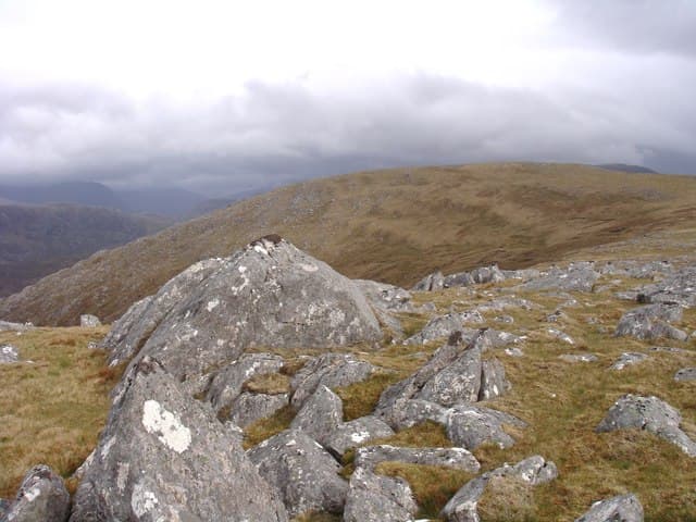
Beinn a' Chaisgein Beag (682m) — the small forbidding hill — lies deep in the Letterewe Wilderness, set in the NG96 square between Loch Maree and Loch a' Bhraoin. It is paired with the larger Beinn a' Chaisgein Mor across the watershed. Its summit outcrop looks out over the Fisherfield Forest, one of the remotest tracts of land in Britain.
Gaelic: “mountain, of the, small” · Pronunciation: bine uh chaisgein bek
Quick facts
- Height
- 682.3m/ 2239ft
- Prominence
- 174 m
- Distance
- 13 km
- Ascent
- 559 m
- Time
- 4–6 hrs
- Grid ref
- NG966821
- Parking
- NG972819
- Nearest
- Ullapool· Inverness 79km
- Dogs
- Dogs on lead required near livestockDog-friendly guide ↗
Height and prominence cross-checked against the Database of British and Irish Hills (CC BY).
No GPX track yet
Walked this route? Share your track to help other walkers.
Standard route
heather moorland 50% · rocky hillside 30% · bog and lochans 20%
From the carpark at Poolewe follow the right of way south-east up the Kernsary track. Continue past Carnmore through the Letterewe estate to reach the bealach below the hill — a 14km walk-in. From the bealach strike north up heather and quartzite slabs to the small cairn on outcrop.
Terrain
Long estate track and stalkers' path, then pathless heather and quartzite block above 500m. The summit outcrop is a small platform of weathered quartzite. The whole approach is committing — there are no easy exits from the Letterewe interior.
In winter
Fisherfield winters are wild and exposed with Atlantic systems sweeping in unimpeded. Snow can lie deep in the corries while the open moors stay bare. The 14km walk-in is the dominant factor — a winter outing here requires bothy nights at Carnmore or Shenavall. SAIS Northern forecasts give the best read.
This hill is in the Torridon SAIS forecast area. Check SAIS forecasts in winter (December–April).
Best time of year
Getting there
- Glasgow4h 20m
- Edinburgh5h 42m
OS maps: OS Landranger 19
Mobile signal: Very poor. Remote Letterewe Wilderness; no reliable coverage.
Current conditions
Daylight Today
- Sunrise
- 04:47
- Sunset
- 22:09
- Civil dawn
- 03:45
- Civil dusk
- 23:11
NOAA Solar Calculator · 17 July 2026
Around Beinn a' Chaisgein Beag on the SCOT network
Getting there, basing yourself, and what to do off the hill.
Beinn a' Chaisgein Beag — common questions
- How difficult is Beinn a' Chaisgein Beag?
- Beinn a' Chaisgein Beag carries a 4/5 (challenging) grade on the OutdoorSCOT scale. Count on about 13km, 559m of ascent and a 4-6 hour day on the standard route. Underfoot: Long estate track and stalkers' path, then pathless heather and quartzite block above 500m.
- What is Beinn a' Chaisgein Beag's prominence?
- 174m of prominence. That's the vertical drop from the summit to the col that links Beinn a' Chaisgein Beag to the next higher ground.
- Where do I park for Beinn a' Chaisgein Beag?
- Most walkers start from NG972819 near Ullapool. Verify the grid reference on an OS map before you set off — space is tight on busy summer weekends.
- When is the best time to climb Beinn a' Chaisgein Beag?
- May, June, July, August, September give the most reliable conditions on Beinn a' Chaisgein Beag. Beyond that window the high ground turns wintry: carry full mountain kit, be confident navigating, and check the SAIS avalanche forecast for the area.
- Is Beinn a' Chaisgein Beag dog-friendly?
- Yes, but dogs must be kept on a lead — there is livestock or ground-nesting bird interest on the route.
- Is there mobile signal on Beinn a' Chaisgein Beag?
- Very poor. Remote Letterewe Wilderness; no reliable coverage.
- Is Beinn a' Chaisgein Beag safe in winter?
- Fisherfield winters are wild and exposed with Atlantic systems sweeping in unimpeded. Snow can lie deep in the corries while the open moors stay bare. The 14km walk-in is the dominant factor — a winter outing here requires bothy nights at Carnmore or Shenavall. SAIS Northern forecasts give the best read.
Get the OutdoorSCOT weekly
One email a week — new route, hill and bothy guides, seasonal conditions and the odd hard-won lesson. No spam, unsubscribe in one click.