Corbett · North-West Highlands
Creag Rainich
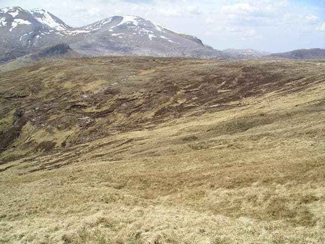
Creag Rainich — "rocky place of the bracken" — sits between Loch a' Bhraoin and Loch an Nid in the rough country north of Loch Broom, on the eastern fringe of the Fisherfield wilderness. At 807m the hill is a 452m-prominence Corbett with a striking three-stacked-slab summit cairn and views westward into An Teallach and the Fisherfield Munros. The position high above the A832 makes it one of the more accessible "Fisherfield-ish" Corbetts, without the river-crossing logistics of the genuine Fisherfield round.
Quick facts
- Height
- 807.9m/ 2651ft
- Prominence
- 452 m
- Distance
- 15 km
- Ascent
- 710 m
- Time
- 5–8 hrs
- Grid ref
- NH096751
- Parking
- NH162761
- Nearest
- Ullapool· Inverness 64km
- Dogs
- Dogs on lead required near livestockDog-friendly guide ↗
Height and prominence cross-checked against the Database of British and Irish Hills (CC BY).
No GPX track yet
Walked this route? Share your track to help other walkers.
Standard route
stalkers path 30% · steep heather 30% · broad ridge 30% · stacked slabs 10%
Start from the lay-by on the A832 east of Braemore Junction and take the stalkers path south-west toward Loch a' Bhraoin. After around 4km, leave the path and climb pathless heather slopes east onto the north ridge of Creag Rainich. The ridge gives a steady pull to the summit cairn. Around 15km return with 710m of ascent. Often combined with Beinn Enaiglair across the bealach for a longer Braemore double.
Terrain
The Loch a' Bhraoin stalkers path is firm. Off the path the climb is steep tussocky heather and grass with no waymarks; the broad north ridge is short grass and small rocky steps. The summit area is broken sandstone blocks with the distinctive three-stacked-slab cairn unmistakable. No exposure on the standard line. The drop east into Loch an Nid is steep and pathless.
In winter
A reasonably serious winter Corbett — the open ridge catches full Atlantic loading and the sandstone summit ices up readily. No avalanche slopes on the standard line but cornices form along the east edge. The A832 is gritted and reliable in any conditions. Phone signal is absent across the route; carry full emergency kit.
This hill is in the Torridon SAIS forecast area. Check SAIS forecasts in winter (December–April).
Best time of year
Getting there
- Glasgow4h 8m
- Edinburgh4h 28m
OS maps: OS Landranger 19
Mobile signal: Intermittent at Braemore Junction; nothing on the hill itself
Current conditions
Daylight Today
- Sunrise
- 04:40
- Sunset
- 22:13
- Civil dawn
- 03:35
- Civil dusk
- 23:18
NOAA Solar Calculator · 13 July 2026
Pair with
Curated multi-hill combinations from Creag Rainich.
Around Creag Rainich on the SCOT network
Getting there, basing yourself, and what to do off the hill.
Creag Rainich — common questions
- Is Creag Rainich a hard climb?
- Creag Rainich is rated 3/5 (moderately challenging) on the OutdoorSCOT scale. The standard route covers about 15km with 710m of ascent and takes most walkers 5-8 hours. Terrain: The Loch a' Bhraoin stalkers path is firm.
- How prominent is Creag Rainich?
- Creag Rainich has 452m of topographic prominence — the height of its summit above the highest col connecting it to higher ground.
- Where should I park to climb Creag Rainich?
- Standard parking is at NH162761 near Ullapool. Check the parking grid reference on an OS map before travel; informal laybys can fill on summer weekends.
- When should I climb Creag Rainich?
- The standard good-weather months for Creag Rainich are May, June, July, August, September. Outside those months, expect winter conditions on the high ground — full mountain kit, navigation skills, and a check of the SAIS avalanche forecast for the relevant region.
- Can I bring my dog up Creag Rainich?
- On a lead only — the route crosses ground with livestock or nesting-bird interest.
- What's mobile reception like on Creag Rainich?
- Intermittent at Braemore Junction; nothing on the hill itself
- Is Creag Rainich safe in winter?
- A reasonably serious winter Corbett — the open ridge catches full Atlantic loading and the sandstone summit ices up readily. No avalanche slopes on the standard line but cornices form along the east edge. The A832 is gritted and reliable in any conditions. Phone signal is absent across the route; carry full emergency kit.
Get the OutdoorSCOT weekly
One email a week — new route, hill and bothy guides, seasonal conditions and the odd hard-won lesson. No spam, unsubscribe in one click.