Corbett · North-West Highlands
Beinn Enaiglair
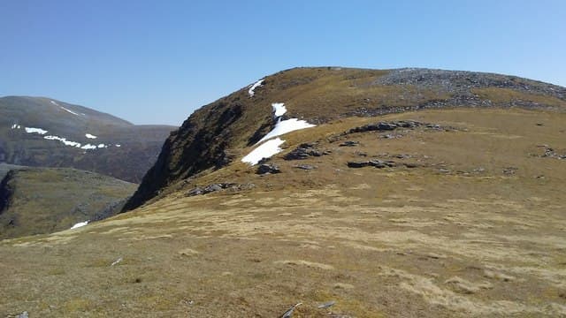
Beinn Enaiglair stands above the south side of Loch Broom, looking out across the Corrieshalloch gorge to An Teallach and the great wedge of Beinn Dearg behind. At 890m it is overshadowed by its Munro neighbours but offers one of the most accessible viewpoints in this corner of Wester Ross — the summit dome is a wide grassy hat with a tiny lochan tucked just below the top. The name translates roughly as "hill of the timid one" and despite the rugged setting the going on its upper slopes is surprisingly gentle.
Quick facts
- Height
- 890m/ 2920ft
- Prominence
- 234 m
- Distance
- 16 km
- Ascent
- 783 m
- Time
- 6–9 hrs
- Grid ref
- NH225805
- Parking
- NH204776
- Nearest
- Ullapool· Inverness 56km
- Dogs
- Dogs on lead required near livestockDog-friendly guide ↗
Height and prominence cross-checked against the Database of British and Irish Hills (CC BY).
No GPX track yet
Walked this route? Share your track to help other walkers.
Standard route
moorland path 30% · heather hillside 40% · grassy ridge 20% · summit area 10%
The usual approach is from the lay-by on the A835 near Braemore Junction, following the old stalkers path that climbs gradually east through Home Loch and onto the broad bealach between Beinn Enaiglair and Iorguill. From the bealach a short pull north-west on grass leads to the summit. The round is about 16km with 783m of ascent. Many parties combine Enaiglair with neighbouring Iorguill (a Graham) on the same out-and-back.
Terrain
The Home Loch stalkers path is one of the better-built tracks in the area and drains well even after rain. Past the bealach the surface becomes close-cropped grass and crowberry — comfortable underfoot, with neither scrambling nor exposed positions. The only navigational care is on the broad summit dome, where the highest point is not obvious and small lochans can disorient in mist.
In winter
The hill is low enough that snow cover is patchy compared to neighbouring Beinn Dearg, but the stalkers path can hold long stretches of black ice in early winter when meltwater refreezes. The summit dome cornices on its north-west edge above the small lochan after westerly storms. In poor visibility the gentle terrain becomes deceptively serious — the bearing back off the top is critical.
This hill is in the Torridon SAIS forecast area. Check SAIS forecasts in winter (December–April).
Best time of year
Getting there
- Glasgow4h 11m
- Edinburgh4h 26m
OS maps: OS Landranger 20
Mobile signal: No signal near Ullapool; brief 1-bar on the summit with views toward the town
Current conditions
Daylight Today
- Sunrise
- 04:39
- Sunset
- 22:13
- Civil dawn
- 03:34
- Civil dusk
- 23:17
NOAA Solar Calculator · 13 July 2026
Around Beinn Enaiglair on the SCOT network
Getting there, basing yourself, and what to do off the hill.
Beinn Enaiglair — common questions
- Is Beinn Enaiglair a hard climb?
- Beinn Enaiglair is rated 3/5 (moderately challenging) on the OutdoorSCOT scale. The standard route covers about 16km with 783m of ascent and takes most walkers 6-9 hours. Terrain: The Home Loch stalkers path is one of the better-built tracks in the area and drains well even after rain.
- How prominent is Beinn Enaiglair?
- Beinn Enaiglair has 234m of topographic prominence — the height of its summit above the highest col connecting it to higher ground.
- Where should I park to climb Beinn Enaiglair?
- Standard parking is at NH204776 near Ullapool. Check the parking grid reference on an OS map before travel; informal laybys can fill on summer weekends.
- When should I climb Beinn Enaiglair?
- The standard good-weather months for Beinn Enaiglair are May, June, July, August, September. Outside those months, expect winter conditions on the high ground — full mountain kit, navigation skills, and a check of the SAIS avalanche forecast for the relevant region.
- Can I bring my dog up Beinn Enaiglair?
- On a lead only — the route crosses ground with livestock or nesting-bird interest.
- What's mobile reception like on Beinn Enaiglair?
- No signal near Ullapool; brief 1-bar on the summit with views toward the town
- Is Beinn Enaiglair safe in winter?
- The hill is low enough that snow cover is patchy compared to neighbouring Beinn Dearg, but the stalkers path can hold long stretches of black ice in early winter when meltwater refreezes. The summit dome cornices on its north-west edge above the small lochan after westerly storms. In poor visibility the gentle terrain becomes deceptively serious — the bearing back off the top is critical.
Get the OutdoorSCOT weekly
One email a week — new route, hill and bothy guides, seasonal conditions and the odd hard-won lesson. No spam, unsubscribe in one click.