Munro · North-West Highlands
Beinn Dearg
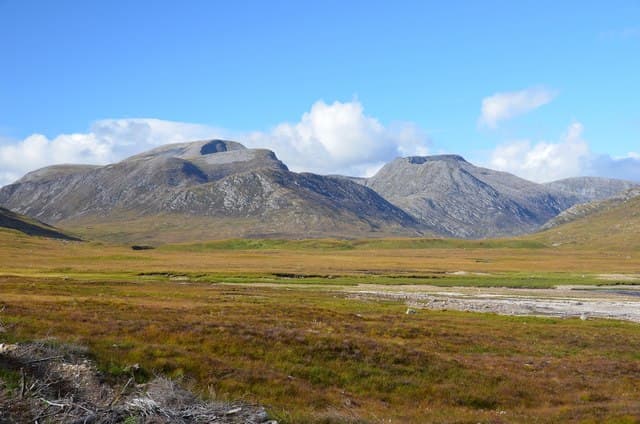
This Beinn Dearg — "red hill", not the Torridon Corbett of the same name — is the 1084m Munro that dominates the south side of Loch Broom, the highest peak in the rough country south of Ullapool. An exceptional 810m of topographic prominence makes it among the most isolated summits in the Northern Highlands, with a striking summit cairn on a small rocky platform and views in every direction. The hill is the gateway to the Beinn Dearg group of four Munros, often climbed together on a long Inverlael round.
Gaelic: “mountain, red” · Pronunciation: bine jerr-ak
Quick facts
- Height
- 1084m/ 3556ft
- Prominence
- 810 m
- Distance
- 18 km
- Ascent
- 954 m
- Time
- 7–10 hrs
- Grid ref
- NH259811
- Parking
- NH183852
- Nearest
- Ullapool· Inverness 54km
- Dogs
- Dogs on lead required near livestockDog-friendly guide ↗
Height and prominence cross-checked against the Database of British and Irish Hills (CC BY).
No GPX track yet
Walked this route? Share your track to help other walkers.
Standard route
Forest track 30% · Glen path 30% · Summit plateau 40%
The standard line is from Inverlael at the head of Loch Broom on the A835, taking the path south up Gleann na Sguaib to the bealach below Beinn Dearg. From the bealach climb the broad south ridge to the summit. Around 18km return with 954m of ascent. Most parties combine Beinn Dearg with Cona Mheall via the connecting bealach, or extend to all four Beinn Dearg Munros for a major day.
Terrain
The Gleann na Sguaib path is firm gravel for most of its length. The climb onto the bealach is steep grass and broken rock. The summit ridge is short heather and stones — broad ground with no exposure. The drop east to Cona Mheall involves a steep descent with one short rocky step. Watch the cliffs above Coire Ghranda — unfenced and edge-undercut.
In winter
A major winter mountain. The Coire Ghranda face holds Grade III-V winter routes including the classic Penguin Gully. Cornicing on the corrie rim is consistent. The Inverlael road from the A835 is gritted. Phone signal is absent above the glen. SAIS Northern Highlands applies.
This hill is in the Torridon SAIS forecast area. Check SAIS forecasts in winter (December–April).
Best time of year
Getting there
- Glasgow4h 12m
- Edinburgh4h 25m
OS maps: OS Landranger 20
Mobile signal: No reception above 700m in the Inverlael Forest. Garve or Ullapool has 4G. Save maps ahead of the trip.
Current conditions
Daylight Today
- Sunrise
- 04:56
- Sunset
- 21:57
- Civil dawn
- 03:58
- Civil dusk
- 22:55
NOAA Solar Calculator · 23 July 2026
Pair with
Curated multi-hill combinations from Beinn Dearg.
Around Beinn Dearg on the SCOT network
Getting there, basing yourself, and what to do off the hill.
Beinn Dearg — common questions
- Is Beinn Dearg a hard climb?
- Beinn Dearg is rated 3/5 (moderately challenging) on the OutdoorSCOT scale. The standard route covers about 18km with 954m of ascent and takes most walkers 7-10 hours. Ground conditions: The Gleann na Sguaib path is firm gravel for most of its length.
- How much drop does Beinn Dearg have?
- The drop is 810m: measured from the summit of Beinn Dearg down to the saddle joining it to higher terrain.
- Where's the parking for Beinn Dearg?
- Park at NH183852 near Ullapool. Double-check the grid reference on an OS map first; informal laybys here fill early in high season.
- What's the best month to climb Beinn Dearg?
- Aim for May, June, July, August, September on Beinn Dearg. In the remaining months treat it as a winter hill — full kit, solid navigation, and a look at the relevant SAIS avalanche forecast before you go.
- Can dogs go up Beinn Dearg?
- Dogs are fine on a lead. The route passes livestock or ground-nesting bird habitat, so keep them close throughout.
- Will I get phone signal on Beinn Dearg?
- No reception above 700m in the Inverlael Forest. Garve or Ullapool has 4G. Save maps ahead of the trip.
- Is Beinn Dearg safe in winter?
- A major winter mountain. The Coire Ghranda face holds Grade III-V winter routes including the classic Penguin Gully. Cornicing on the corrie rim is consistent. The Inverlael road from the A835 is gritted. Phone signal is absent above the glen. SAIS Northern Highlands applies.
Get the OutdoorSCOT weekly
One email a week — new route, hill and bothy guides, seasonal conditions and the odd hard-won lesson. No spam, unsubscribe in one click.