Graham · North-West Highlands
Meall Doire Faid
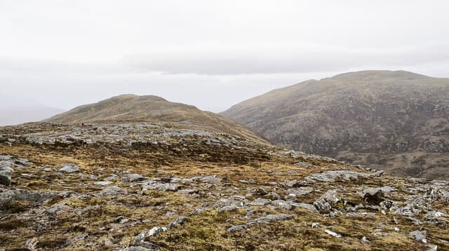
A roadside Graham above the Dirrie More on the A835 between Garve and Ullapool. Easy access from the road makes it a popular leg-stretcher for travellers heading north. 728 m summit, 13 km out-and-back from Ullapool, 597 m of ascent. North-West Highlands.
Quick facts
- Height
- 728.8m/ 2391ft
- Prominence
- 175 m
- Distance
- 13 km
- Ascent
- 597 m
- Time
- 4–6 hrs
- Grid ref
- NH220792
- Parking
- NH223795
- Nearest
- Ullapool· Inverness 56km
- Dogs
- Dogs on lead required near livestockDog-friendly guide ↗
Height and prominence cross-checked against the Database of British and Irish Hills (CC BY).
No GPX track yet
Walked this route? Share your track to help other walkers.
Standard route
glen track 25% · rough heather 45% · grassy upper slopes 20% · summit area 10%
Park at the layby near the Allt na Lairige Moire on the A835. A faint path heads south-west across the moor and up the broad north-east ridge. The summit trig stands on a wide stony plateau.
Terrain
Boggy moorland for the first kilometre, then firmer ground on the ridge. Quartzite blocks scattered across the summit plateau. No real path beyond the moor crossing.
In winter
The Dirrie More is one of the snowier mainland passes — A835 closures are common in storms. Once on the hill the angle is gentle but the plateau navigation is demanding under cloud or fresh snowfall.
This hill is in the Torridon SAIS forecast area. Check SAIS forecasts in winter (December–April).
Best time of year
Getting there
- Glasgow4h 10m
- Edinburgh4h 25m
OS maps: OS Landranger 20
Mobile signal: Reception along the A835; gone within ten minutes of leaving the road
Current conditions
Daylight Today
- Sunrise
- 04:39
- Sunset
- 22:13
- Civil dawn
- 03:34
- Civil dusk
- 23:17
NOAA Solar Calculator · 13 July 2026
Around Meall Doire Faid on the SCOT network
Getting there, basing yourself, and what to do off the hill.
Meall Doire Faid — common questions
- What difficulty is Meall Doire Faid?
- On the OutdoorSCOT scale, Meall Doire Faid comes in at 4/5 — challenging. Expect roughly 13km and 597m of ascent on the usual route — 4-6 hours for most parties. Ground conditions: Boggy moorland for the first kilometre, then firmer ground on the ridge.
- How much drop does Meall Doire Faid have?
- The drop is 175m: measured from the summit of Meall Doire Faid down to the saddle joining it to higher terrain.
- Where's the parking for Meall Doire Faid?
- Park at NH223795 near Ullapool. Double-check the grid reference on an OS map first; informal laybys here fill early in high season.
- What's the best month to climb Meall Doire Faid?
- Aim for May, June, July, August, September on Meall Doire Faid. In the remaining months treat it as a winter hill — full kit, solid navigation, and a look at the relevant SAIS avalanche forecast before you go.
- Can dogs go up Meall Doire Faid?
- Dogs are fine on a lead. The route passes livestock or ground-nesting bird habitat, so keep them close throughout.
- Will I get phone signal on Meall Doire Faid?
- Reception along the A835; gone within ten minutes of leaving the road
- Is Meall Doire Faid safe in winter?
- The Dirrie More is one of the snowier mainland passes — A835 closures are common in storms. Once on the hill the angle is gentle but the plateau navigation is demanding under cloud or fresh snowfall.
Get the OutdoorSCOT weekly
One email a week — new route, hill and bothy guides, seasonal conditions and the odd hard-won lesson. No spam, unsubscribe in one click.