Graham · North-West Highlands
Beinn Bhreac (Meall Dubh)
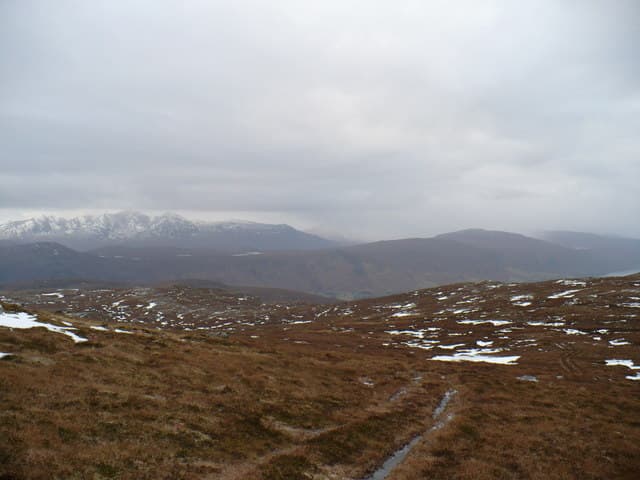
Beinn Bhreac, also known as Meall Dubh (666m), is a twin-topped moorland mass north of Strath Vaich in the NH28 square, deep in the wide Easter Ross hinterland. The cairn caps the western top with a second high point — the black lump of Meall Dubh — to the east. The view sweeps north over the trackless Freevater country toward Seana Bhraigh.
Quick facts
- Height
- 666.3m/ 2186ft
- Prominence
- 159 m
- Distance
- 13 km
- Ascent
- 546 m
- Time
- 4–6 hrs
- Grid ref
- NH225886
- Parking
- NH230873
- Nearest
- Ullapool· Inverness 62km
- Dogs
- Dogs on lead required near livestockDog-friendly guide ↗
Height and prominence cross-checked against the Database of British and Irish Hills (CC BY).
No GPX track yet
Walked this route? Share your track to help other walkers.
Standard route
heather moorland 60% · bog and wet grass 25% · rocky outcrops 15%
Park at the gate beside Loch Vaich on the private estate road north from Garbat. Cycle the long landrover track up to Lubachlaggan if estate access allows, then climb the south flank directly through ankle-deep heather and bog onto the western top. A short walk east across boggy ground reaches Meall Dubh — both should be visited for the full Graham status.
Terrain
Estate road for several miles of the approach — bring a bike. Above the track the going is bog, tussock and patchy heather. The col between the two tops is wet and broken; firm ground is rare anywhere on this hill.
In winter
Easter Ross moorlands hold a thin, wind-blown cover with the deepest snow in the burn heads between the two tops. The vast expanse makes navigation in cloud demanding — there is no landform to aim for once on the broad summit area. Frozen bog gives the easiest walking conditions.
This hill is in the Torridon SAIS forecast area. Check SAIS forecasts in winter (December–April).
Best time of year
Getting there
- Glasgow4h 21m
- Edinburgh5h 34m
OS maps: OS Landranger 20
Mobile signal: Poor. Remote Loch Rannoch/Loch Ericht area; limited coverage.
Current conditions
Daylight Today
- Sunrise
- 04:45
- Sunset
- 22:07
- Civil dawn
- 03:42
- Civil dusk
- 23:10
NOAA Solar Calculator · 17 July 2026
Around Beinn Bhreac (Meall Dubh) on the SCOT network
Getting there, basing yourself, and what to do off the hill.
Beinn Bhreac (Meall Dubh) — common questions
- What difficulty is Beinn Bhreac (Meall Dubh)?
- On the OutdoorSCOT scale, Beinn Bhreac (Meall Dubh) comes in at 4/5 — challenging. Expect roughly 13km and 546m of ascent on the usual route — 4-6 hours for most parties. Terrain: Estate road for several miles of the approach — bring a bike.
- How prominent is Beinn Bhreac (Meall Dubh)?
- Beinn Bhreac (Meall Dubh) has 159m of topographic prominence — the height of its summit above the highest col connecting it to higher ground.
- Where should I park to climb Beinn Bhreac (Meall Dubh)?
- Standard parking is at NH230873 near Ullapool. Check the parking grid reference on an OS map before travel; informal laybys can fill on summer weekends.
- When should I climb Beinn Bhreac (Meall Dubh)?
- The standard good-weather months for Beinn Bhreac (Meall Dubh) are May, June, July, August, September. Outside those months, expect winter conditions on the high ground — full mountain kit, navigation skills, and a check of the SAIS avalanche forecast for the relevant region.
- Can I bring my dog up Beinn Bhreac (Meall Dubh)?
- On a lead only — the route crosses ground with livestock or nesting-bird interest.
- What's mobile reception like on Beinn Bhreac (Meall Dubh)?
- Poor. Remote Loch Rannoch/Loch Ericht area; limited coverage.
- Is Beinn Bhreac (Meall Dubh) safe in winter?
- Easter Ross moorlands hold a thin, wind-blown cover with the deepest snow in the burn heads between the two tops. The vast expanse makes navigation in cloud demanding — there is no landform to aim for once on the broad summit area. Frozen bog gives the easiest walking conditions.
Get the OutdoorSCOT weekly
One email a week — new route, hill and bothy guides, seasonal conditions and the odd hard-won lesson. No spam, unsubscribe in one click.