Graham · North-West Highlands
Carn a' Choin Deirg
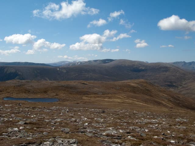
Carn a' Choin Deirg (701m) is a quartzite-capped hill in the rolling moors north of Glen Cassley, set in the NH39 square between Strath Oykel and Loch Shin. The name means cairn of the red dog. With its 319m of prominence it stands clear of its neighbours and earns a trig pillar on the long summit ridge.
Quick facts
- Height
- 701m/ 2300ft
- Prominence
- 319 m
- Distance
- 13 km
- Ascent
- 575 m
- Time
- 4–6 hrs
- Grid ref
- NH397923
- Parking
- NH381923
- Nearest
- Ullapool· Inverness 54km
- Dogs
- Dogs on lead required near livestockDog-friendly guide ↗
Height and prominence cross-checked against the Database of British and Irish Hills (CC BY).
No GPX track yet
Walked this route? Share your track to help other walkers.
Standard route
heather moorland 65% · grass and sedge 25% · summit plateau 10%
From the small parking pull-off on the Oykel Bridge to Lairg road follow the landrover track north-east up the Allt a' Choin Deirg for around 3km. Leave the track at a hairpin and strike north-west across heather and lochans to gain the broad south ridge. A faint stalkers' path then weaves through peat hags to the trig pillar.
Terrain
Estate road for the first stretch, then a long pull across knee-deep heather and dotted lochans. The summit ridge is broad and barren, scattered with white quartzite blocks. Persistent bog around the headwaters of the burn demands gaiters.
In winter
Sutherland's eastern moors get less snow than the west but it lies long in the peat hags and drifting on this featureless plateau can fill the burn channels overnight. Compass work is critical when cloud closes in. Daylight collapses to under seven hours at midwinter on this NH39 latitude.
This hill is in the Torridon SAIS forecast area. Check SAIS forecasts in winter (December–April).
Best time of year
Getting there
- Glasgow4h 23m
- Edinburgh5h 30m
OS maps: OS Landranger 20
Mobile signal: Poor. Fairly remote location north of Glen Garry; signal is marginal here.
Current conditions
Daylight Today
- Sunrise
- 04:37
- Sunset
- 22:12
- Civil dawn
- 03:31
- Civil dusk
- 23:18
NOAA Solar Calculator · 13 July 2026
Around Carn a' Choin Deirg on the SCOT network
Getting there, basing yourself, and what to do off the hill.
Carn a' Choin Deirg — common questions
- How difficult is Carn a' Choin Deirg?
- Carn a' Choin Deirg carries a 4/5 (challenging) grade on the OutdoorSCOT scale. Count on about 13km, 575m of ascent and a 4-6 hour day on the standard route. Terrain: Estate road for the first stretch, then a long pull across knee-deep heather and dotted lochans.
- How prominent is Carn a' Choin Deirg?
- Carn a' Choin Deirg has 319m of topographic prominence — the height of its summit above the highest col connecting it to higher ground.
- Where should I park to climb Carn a' Choin Deirg?
- Standard parking is at NH381923 near Ullapool. Check the parking grid reference on an OS map before travel; informal laybys can fill on summer weekends.
- When should I climb Carn a' Choin Deirg?
- The standard good-weather months for Carn a' Choin Deirg are May, June, July, August, September. Outside those months, expect winter conditions on the high ground — full mountain kit, navigation skills, and a check of the SAIS avalanche forecast for the relevant region.
- Can I bring my dog up Carn a' Choin Deirg?
- On a lead only — the route crosses ground with livestock or nesting-bird interest.
- What's mobile reception like on Carn a' Choin Deirg?
- Poor. Fairly remote location north of Glen Garry; signal is marginal here.
- Is Carn a' Choin Deirg safe in winter?
- Sutherland's eastern moors get less snow than the west but it lies long in the peat hags and drifting on this featureless plateau can fill the burn channels overnight. Compass work is critical when cloud closes in. Daylight collapses to under seven hours at midwinter on this NH39 latitude.
Get the OutdoorSCOT weekly
One email a week — new route, hill and bothy guides, seasonal conditions and the odd hard-won lesson. No spam, unsubscribe in one click.