Corbett · North-West Highlands
Carn Ban
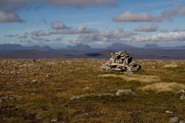
Càrn Bàn — 'the white cairn' — is the 843m Corbett standing in the remote upper reaches of Strath Vaich, north of Garve. The mountain sits within the Strathvaich deer forest, and the standard approach is via a long estate track that drives east from the A835 into the heart of the deer country. The summit gives a striking view across Inverlael forest to An Teallach and toward Beinn Dearg. A genuinely empty hill day; you can walk a full round without meeting another party.
Gaelic: “cairn-topped hill, fair” · Pronunciation: karn bahn
Quick facts
- Height
- 843.3m/ 2767ft
- Prominence
- 205 m
- Distance
- 30 km
- Ascent
- 700 m
- Time
- 7–11 hrs
- Grid ref
- NH338875
- Parking
- NH349720
- Nearest
- Ullapool· Inverness 53km
- Dogs
- Dogs on lead required near livestockDog-friendly guide ↗
Height and prominence cross-checked against the Database of British and Irish Hills (CC BY).
No GPX track yet
Walked this route? Share your track to help other walkers.
Standard route
estate track 30% · bog and heather 40% · plateau grass 20% · summit area 10%
Park at the small layby near Black Bridge on the A835 (NH349720), just north of the Aultguish Inn. Cycle or walk the Strathvaich estate track east-north-east for around 10km to the head of Loch Vaich, then climb north-east onto Càrn Bàn's broad south ridge. The route gains the summit cairn through short grass and peat. Return reverses the line — bike makes the day materially shorter. Allow 9–10 hours on foot, 7 with a bike.
Terrain
Long Strathvaich Lodge estate track — well-built, ideal for cycling. Beyond the track end the going is heather, peat hag and short grass. The summit area is broad and gently rolling; in cloud, the broad plateau demands accurate compass work. Stalking activity restricts access in deer season — check before driving up.
In winter
A long winter day in remote country. Drift builds along the Strathvaich track in north-easterly winds and the bike has to be left behind once snow lies. Cover persists for weeks on the broad summit. No phone signal anywhere beyond the A835. Plan with a hard turn-back time given the midwinter daylight window.
This hill is in the Torridon SAIS forecast area. Check SAIS forecasts in winter (December–April).
Best time of year
Getting there
- Glasgow4h 18m
- Edinburgh4h 28m
OS maps: OS Landranger 20
Mobile signal: Brief EE/Vodafone at the A835 layby; no usable signal once into Strathvaich. The whole catchment is a mobile blackspot
Current conditions
Daylight Today
- Sunrise
- 04:37
- Sunset
- 22:12
- Civil dawn
- 03:32
- Civil dusk
- 23:18
NOAA Solar Calculator · 13 July 2026
Around Carn Ban on the SCOT network
Getting there, basing yourself, and what to do off the hill.
Carn Ban — common questions
- How difficult is Carn Ban?
- Carn Ban carries a 3/5 (moderately challenging) grade on the OutdoorSCOT scale. Count on about 30km, 700m of ascent and a 7-11 hour day on the standard route. Underfoot: Long Strathvaich Lodge estate track — well-built, ideal for cycling.
- What is Carn Ban's prominence?
- 205m of prominence. That's the vertical drop from the summit to the col that links Carn Ban to the next higher ground.
- Where do I park for Carn Ban?
- Most walkers start from NH349720 near Ullapool. Verify the grid reference on an OS map before you set off — space is tight on busy summer weekends.
- When is the best time to climb Carn Ban?
- May, June, July, August, September give the most reliable conditions on Carn Ban. Beyond that window the high ground turns wintry: carry full mountain kit, be confident navigating, and check the SAIS avalanche forecast for the area.
- Is Carn Ban dog-friendly?
- Yes, but dogs must be kept on a lead — there is livestock or ground-nesting bird interest on the route.
- Is there mobile signal on Carn Ban?
- Brief EE/Vodafone at the A835 layby; no usable signal once into Strathvaich. The whole catchment is a mobile blackspot
- Is Carn Ban safe in winter?
- A long winter day in remote country. Drift builds along the Strathvaich track in north-easterly winds and the bike has to be left behind once snow lies. Cover persists for weeks on the broad summit. No phone signal anywhere beyond the A835. Plan with a hard turn-back time given the midwinter daylight window.
Get the OutdoorSCOT weekly
One email a week — new route, hill and bothy guides, seasonal conditions and the odd hard-won lesson. No spam, unsubscribe in one click.