Corbett · Central Highlands
Beinn a' Chaisteil
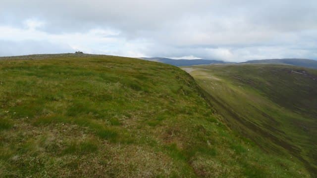
This Beinn a' Chaisteil — "castle hill", distinct from the Auch Corbett of the same name — is the 787m Corbett in the empty Easter Ross deer-forest country north-west of Bonar Bridge. The hill sits on the Alladale watershed near its better-known neighbour Carn Chuinneag, with the summit a rocky cairn on a broad heather plateau. The position high on the deer-forest watershed gives views east to the Dornoch Firth coast and west into the Glen Beag wilderness.
Gaelic: “mountain, of the, castle” · Pronunciation: bine uh chash-til
Quick facts
- Height
- 787m/ 2582ft
- Prominence
- 280 m
- Distance
- 14 km
- Ascent
- 645 m
- Time
- 4–7 hrs
- Grid ref
- NH369801
- Parking
- NH468906
- Nearest
- Ullapool· Inverness 46km
- Dogs
- Dogs on lead required near livestockDog-friendly guide ↗
Height and prominence cross-checked against the Database of British and Irish Hills (CC BY).
No GPX track yet
Walked this route? Share your track to help other walkers.
Standard route
estate road 45% · rough heather 25% · broad ridge 20% · summit cairn 10%
Start from the Alladale Wilderness Reserve gate at Glencalvie and follow the long estate road north-west into upper Strathcarron. After roughly 5km of track, leave it and climb pathless heather slopes north onto the broad east ridge of Beinn a' Chaisteil. Around 14km return with 645m of ascent — bike strongly recommended for the track approach. Often combined with Carn Chuinneag for a long Easter Ross day.
Terrain
The Alladale estate track is well-graded gravel. Off the track the ground is rough heather with patches of peat hag — slow walking. The wide summit ridge is short heather and grass with the rocky cairn marking the high point. No scrambling and no exposed ground anywhere. The Alladale rewilding programme has introduced wildcats and other species in the surrounding glens; keep dogs leashed.
In winter
A reasonably benign winter hill — gentle gradients, no avalanche slopes, and reliable estate-track approach. The summit plateau is featureless in whiteout. The Alladale access road can drift up in heavy snow. Phone signal is absent throughout; carry full emergency kit for this remote setting.
This hill is in the Creag Meagaidh SAIS forecast area. Check SAIS forecasts in winter (December–April).
Best time of year
Getting there
- Glasgow4h 9m
- Edinburgh4h 19m
OS maps: OS Landranger 20
Mobile signal: No signal in Strathcarron beyond Ardgay; nothing on the hill
Current conditions
Daylight Today
- Sunrise
- 04:38
- Sunset
- 22:12
- Civil dawn
- 03:33
- Civil dusk
- 23:17
NOAA Solar Calculator · 13 July 2026
Around Beinn a' Chaisteil on the SCOT network
Getting there, basing yourself, and what to do off the hill.
Beinn a' Chaisteil — common questions
- How difficult is Beinn a' Chaisteil?
- Beinn a' Chaisteil carries a 2/5 (moderate) grade on the OutdoorSCOT scale. Count on about 14km, 645m of ascent and a 4-7 hour day on the standard route. Underfoot: The Alladale estate track is well-graded gravel.
- What is Beinn a' Chaisteil's prominence?
- 280m of prominence. That's the vertical drop from the summit to the col that links Beinn a' Chaisteil to the next higher ground.
- Where do I park for Beinn a' Chaisteil?
- Most walkers start from NH468906 near Ullapool. Verify the grid reference on an OS map before you set off — space is tight on busy summer weekends.
- When is the best time to climb Beinn a' Chaisteil?
- May, June, July, August, September give the most reliable conditions on Beinn a' Chaisteil. Beyond that window the high ground turns wintry: carry full mountain kit, be confident navigating, and check the SAIS avalanche forecast for the area.
- Is Beinn a' Chaisteil dog-friendly?
- Yes, but dogs must be kept on a lead — there is livestock or ground-nesting bird interest on the route.
- Is there mobile signal on Beinn a' Chaisteil?
- No signal in Strathcarron beyond Ardgay; nothing on the hill
- Is Beinn a' Chaisteil safe in winter?
- A reasonably benign winter hill — gentle gradients, no avalanche slopes, and reliable estate-track approach. The summit plateau is featureless in whiteout. The Alladale access road can drift up in heavy snow. Phone signal is absent throughout; carry full emergency kit for this remote setting.
Get the OutdoorSCOT weekly
One email a week — new route, hill and bothy guides, seasonal conditions and the odd hard-won lesson. No spam, unsubscribe in one click.