Graham · Central Highlands
Carn Loch nan Amhaichean
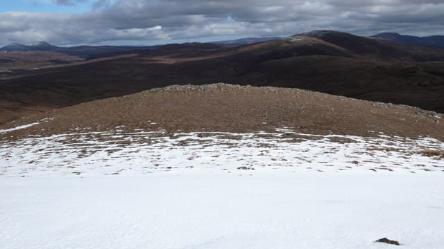
Carn Loch nan Amhaichean (697m) is a remote moorland hill north of Strathvaich, set in the NH47 square between Loch Vaich and the Aultguish hills. The name means cairn of the loch of the necks — a reference to the curving lochan below its eastern face. Few hills in the Highlands feel as removed from the road, and the summit cairn looks out across an unbroken sweep of peatland.
Quick facts
- Height
- 697.3m/ 2288ft
- Prominence
- 205 m
- Distance
- 13 km
- Ascent
- 572 m
- Time
- 4–6 hrs
- Grid ref
- NH411757
- Parking
- NH409772
- Nearest
- Ullapool· Inverness 40km
- Dogs
- Dogs on lead required near livestockDog-friendly guide ↗
Height and prominence cross-checked against the Database of British and Irish Hills (CC BY).
No GPX track yet
Walked this route? Share your track to help other walkers.
Standard route
heather moorland 65% · bog and rushes 25% · grassy summit 10%
From the locked gate at Lubfearn on the A835 take the private estate road south up Strath Vaich. After about 6km cross the bridge at the lodge and strike east up the broad shoulder on heather. The summit lies on a flat tableland marked by twin cairns.
Terrain
Long estate road on the approach, then deep heather and lochan-spangled moor above 400m. The summit plateau is short cropped grass and quartzite blocks. Bog around the headwater burns demands gaiters even in dry weather.
In winter
The strath catches Atlantic moisture but the high moors freeze hard once the wind swings to the north-east. Drifting across the featureless top is the main hazard, with snow filling burn channels overnight. The very short midwinter day combined with the long approach makes a benightment a real risk.
This hill is in the Creag Meagaidh SAIS forecast area. Check SAIS forecasts in winter (December–April).
Best time of year
Getting there
- Glasgow4h 3m
- Edinburgh4h 12m
OS maps: OS Landranger 20
Mobile signal: Poor. Very remote Wester Ross location; no reliable coverage.
Current conditions
Daylight Today
- Sunrise
- 04:44
- Sunset
- 22:05
- Civil dawn
- 03:42
- Civil dusk
- 23:07
NOAA Solar Calculator · 17 July 2026
Around Carn Loch nan Amhaichean on the SCOT network
Getting there, basing yourself, and what to do off the hill.
Getting there: Dingwall station
Ben Wyvis approach; Easter Ross; junction for Kyle and Far North lines
22km from the hill
tripscot.co.uk
On TripSCOTBase yourself in Ullapool
Main NW Highlands hub; Hebrides ferry; Inverpolly access
34km from the hill
tripscot.co.uk
On TasteSCOTAfter the hill: The Dalmore
Alness — sherried Highland flagship; stately Cromarty Firth setting
25km from the hill
tastescot.co.uk
Carn Loch nan Amhaichean — common questions
- How hard is Carn Loch nan Amhaichean?
- We grade Carn Loch nan Amhaichean at 4/5, which puts it in challenging territory. The usual route is around 13km with 572m of climbing; allow 4-6 hours. Terrain: Long estate road on the approach, then deep heather and lochan-spangled moor above 400m.
- How prominent is Carn Loch nan Amhaichean?
- Carn Loch nan Amhaichean has 205m of topographic prominence — the height of its summit above the highest col connecting it to higher ground.
- Where should I park to climb Carn Loch nan Amhaichean?
- Standard parking is at NH409772 near Ullapool. Check the parking grid reference on an OS map before travel; informal laybys can fill on summer weekends.
- When should I climb Carn Loch nan Amhaichean?
- The standard good-weather months for Carn Loch nan Amhaichean are May, June, July, August, September. Outside those months, expect winter conditions on the high ground — full mountain kit, navigation skills, and a check of the SAIS avalanche forecast for the relevant region.
- Can I bring my dog up Carn Loch nan Amhaichean?
- On a lead only — the route crosses ground with livestock or nesting-bird interest.
- What's mobile reception like on Carn Loch nan Amhaichean?
- Poor. Very remote Wester Ross location; no reliable coverage.
- Is Carn Loch nan Amhaichean safe in winter?
- The strath catches Atlantic moisture but the high moors freeze hard once the wind swings to the north-east. Drifting across the featureless top is the main hazard, with snow filling burn channels overnight. The very short midwinter day combined with the long approach makes a benightment a real risk.
Get the OutdoorSCOT weekly
One email a week — new route, hill and bothy guides, seasonal conditions and the odd hard-won lesson. No spam, unsubscribe in one click.