Graham · Central Highlands
Beinn nan Eun
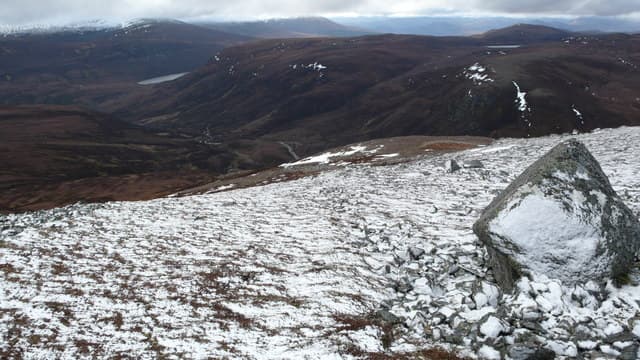
The hill of the birds rises above Loch Glass at the head of Strathrusdale in Easter Ross, paired closely with the Corbett Beinn Tharsuinn to the north. A rounded summit with broad shoulders and a small cairn marking the centre of the dome.
Quick facts
- Height
- 743.1m/ 2438ft
- Prominence
- 255 m
- Distance
- 14 km
- Ascent
- 609 m
- Time
- 4–7 hrs
- Grid ref
- NH448759
- Parking
- NH515742
- Nearest
- Ullapool· Inverness 38km
- Dogs
- Dogs on lead required near livestockDog-friendly guide ↗
Height and prominence cross-checked against the Database of British and Irish Hills (CC BY).
No GPX track yet
Walked this route? Share your track to help other walkers.
Standard route
glen track 25% · heather hillside 45% · grassy upper ridge 20% · summit area 10%
Start at the road end past Loch Morie and follow the stalkers' track to Lochan Sgeireach. From the lochan a faint line climbs west onto the broad ridge and then south to the cairn.
Terrain
Stalkers' track for most of the approach. The upper hill is open heather and short grass with occasional peat banks.
In winter
A modest but exposed Easter Ross summit. Snow patches and frozen tussock are typical mid-winter conditions; ice axe useful for the steeper northern flank if descending toward Beinn Tharsuinn.
This hill is in the Creag Meagaidh SAIS forecast area. Check SAIS forecasts in winter (December–April).
Best time of year
Getting there
- Glasgow4h 3m
- Edinburgh4h 11m
OS maps: OS Landranger 20
Mobile signal: Zero signal in this remote Loch Garry/Knoydart area
Current conditions
Daylight Today
- Sunrise
- 04:37
- Sunset
- 22:11
- Civil dawn
- 03:33
- Civil dusk
- 23:16
NOAA Solar Calculator · 13 July 2026
Around Beinn nan Eun on the SCOT network
Getting there, basing yourself, and what to do off the hill.
Getting there: Dingwall station
Ben Wyvis approach; Easter Ross; junction for Kyle and Far North lines
20km from the hill
tripscot.co.uk
On TripSCOTBase yourself in Ullapool
Main NW Highlands hub; Hebrides ferry; Inverpolly access
37km from the hill
tripscot.co.uk
On TasteSCOTAfter the hill: The Dalmore
Alness — sherried Highland flagship; stately Cromarty Firth setting
22km from the hill
tastescot.co.uk
Beinn nan Eun — common questions
- How hard is Beinn nan Eun?
- We grade Beinn nan Eun at 4/5, which puts it in challenging territory. The usual route is around 14km with 609m of climbing; allow 4-7 hours. Ground conditions: Stalkers' track for most of the approach.
- How much drop does Beinn nan Eun have?
- The drop is 255m: measured from the summit of Beinn nan Eun down to the saddle joining it to higher terrain.
- Where's the parking for Beinn nan Eun?
- Park at NH515742 near Ullapool. Double-check the grid reference on an OS map first; informal laybys here fill early in high season.
- What's the best month to climb Beinn nan Eun?
- Aim for May, June, July, August, September on Beinn nan Eun. In the remaining months treat it as a winter hill — full kit, solid navigation, and a look at the relevant SAIS avalanche forecast before you go.
- Can dogs go up Beinn nan Eun?
- Dogs are fine on a lead. The route passes livestock or ground-nesting bird habitat, so keep them close throughout.
- Will I get phone signal on Beinn nan Eun?
- Zero signal in this remote Loch Garry/Knoydart area
- Is Beinn nan Eun safe in winter?
- A modest but exposed Easter Ross summit. Snow patches and frozen tussock are typical mid-winter conditions; ice axe useful for the steeper northern flank if descending toward Beinn Tharsuinn.
Get the OutdoorSCOT weekly
One email a week — new route, hill and bothy guides, seasonal conditions and the odd hard-won lesson. No spam, unsubscribe in one click.