Graham · Central Highlands
Carn Salachaidh
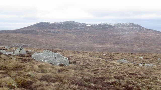
Carn Salachaidh (648m) — the willow cairn — is a Easter Ross hill in the NH58 square above Strathcarron, north of Ardgay. A large granite boulder marks the high point of a broad, peaty plateau looking north across Glen Calvie to the bare Sutherland watershed.
Quick facts
- Height
- 648m/ 2126ft
- Prominence
- 235 m
- Distance
- 12 km
- Ascent
- 486 m
- Time
- 3–5 hrs
- Grid ref
- NH518874
- Parking
- NH457915
- Nearest
- Ullapool· Inverness 45km
- Dogs
- Dogs on lead required near livestockDog-friendly guide ↗
Height and prominence cross-checked against the Database of British and Irish Hills (CC BY).
No GPX track yet
Walked this route? Share your track to help other walkers.
Standard route
heather moorland 60% · bog and rushes 30% · grassy summit 10%
Start from the parking near Croick Church at the head of Strathcarron. Follow the public road north-east and pick up the estate landrover track climbing past Glencalvie Lodge into Glen Calvie. Leave the track on a quad rut south-west to gain the rounded plateau, then walk to the granite boulder at the high point.
Terrain
Good track in Glen Calvie, then quad rut and trackless ground across the plateau. Underfoot is firm peat with patches of bare gravel; the granite boulder is unmistakable but its surrounding plateau looks all the same in mist.
In winter
Strathcarron catches drifting easterly snow that fills the plateau hollows quickly. Carn Salachaidh's open top is exposed to wind chill from any direction and there is no shelter once off the track. The northern latitude makes daylight precious so a winter visit needs an early Croick start.
This hill is in the Creag Meagaidh SAIS forecast area. Check SAIS forecasts in winter (December–April).
Best time of year
Getting there
- Glasgow4h 16m
- Edinburgh4h 20m
OS maps: OS Landranger 20
Mobile signal: Poor. Remote Glen Calvie / Croick area; weak on all networks.
Current conditions
Daylight Today
- Sunrise
- 04:36
- Sunset
- 22:11
- Civil dawn
- 03:31
- Civil dusk
- 23:16
NOAA Solar Calculator · 13 July 2026
Around Carn Salachaidh on the SCOT network
Getting there, basing yourself, and what to do off the hill.
Getting there: Ardgay station
Kyle of Sutherland; Croick; Far North Line
8km from the hill
tripscot.co.uk
On TripSCOTBase yourself in Ullapool
Main NW Highlands hub; Hebrides ferry; Inverpolly access
39km from the hill
tripscot.co.uk
On TasteSCOTAfter the hill: Balblair
Edderton — Easter Ross distillery with vintage-led range
19km from the hill
tastescot.co.uk
Carn Salachaidh — common questions
- How hard is Carn Salachaidh?
- We grade Carn Salachaidh at 3/5, which puts it in moderately challenging territory. The usual route is around 12km with 486m of climbing; allow 3-5 hours. Ground conditions: Good track in Glen Calvie, then quad rut and trackless ground across the plateau.
- How much drop does Carn Salachaidh have?
- The drop is 235m: measured from the summit of Carn Salachaidh down to the saddle joining it to higher terrain.
- Where's the parking for Carn Salachaidh?
- Park at NH457915 near Ullapool. Double-check the grid reference on an OS map first; informal laybys here fill early in high season.
- What's the best month to climb Carn Salachaidh?
- Aim for May, June, July, August, September on Carn Salachaidh. In the remaining months treat it as a winter hill — full kit, solid navigation, and a look at the relevant SAIS avalanche forecast before you go.
- Can dogs go up Carn Salachaidh?
- Dogs are fine on a lead. The route passes livestock or ground-nesting bird habitat, so keep them close throughout.
- Will I get phone signal on Carn Salachaidh?
- Poor. Remote Glen Calvie / Croick area; weak on all networks.
- Is Carn Salachaidh safe in winter?
- Strathcarron catches drifting easterly snow that fills the plateau hollows quickly. Carn Salachaidh's open top is exposed to wind chill from any direction and there is no shelter once off the track. The northern latitude makes daylight precious so a winter visit needs an early Croick start.
Get the OutdoorSCOT weekly
One email a week — new route, hill and bothy guides, seasonal conditions and the odd hard-won lesson. No spam, unsubscribe in one click.