Corbett · North-West Highlands
Beinn Dearg
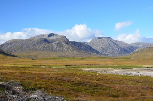
Beinn Dearg of Torridon — not to be confused with the Munro of the same name above Ullapool — is the only Corbett squeezed between Liathach and Beinn Alligin at the core of Torridon. At 913m it is among the highest Corbetts in Britain and has long been argued to deserve Munro status, missing the 914.4m cut by little more than a metre. The summit ridge is a magnificent line of Torridonian sandstone steps with airy positions, often described as a "missing Munro" of the Torridon group and rated by many as the finest Corbett in the country.
Gaelic: “mountain, red” · Pronunciation: bine jerr-ak
Quick facts
- Height
- 913.7m/ 2998ft
- Prominence
- 469 m
- Distance
- 16 km
- Ascent
- 803 m
- Time
- 6–9 hrs
- Grid ref
- NG895608
- Parking
- NG868576
- Nearest
- Ullapool· Inverness 78km
- Dogs
- Dogs on lead required near livestockDog-friendly guide ↗
Height and prominence cross-checked against the Database of British and Irish Hills (CC BY).
No GPX track yet
Walked this route? Share your track to help other walkers.
Standard route
forest path 20% · open hillside 25% · sandstone scramble 45% · summit ridge 10%
Start from Coire Mhic Nobuil car park on the Diabaig road and follow the path north toward the Bealach a Chomhla between Beinn Alligin and Beinn Dearg. From the bealach, climb the south-west ridge — this is the technical heart of the day, with several rocky steps requiring careful route-finding and easy scrambling. The summit ridge runs north-east over an awkward sandstone step. Around 16km return with 803m of ascent. Most parties retrace the line; the traverse east continues to Carn na Feola but is committing.
Terrain
The Coire Mhic Nobuil path is firm and clear to the bealach. Beyond, the south-west ridge is a sustained scramble — large sandstone blocks, short walls and exposed steps with a Grade 1 difficulty most of the way. The summit ridge itself has one notorious step where down-climbing a few metres of rock is required. There is no easy bad-weather alternative; routes off the ridge are crag-bound on both sides.
In winter
A proper alpine outing under snow and ice. The sandstone steps that are easy scrambling in summer become serious mixed climbing in winter, with rime-coated blocks, hidden ice and corniced exposed sections of ridge. Most winter ascensions are by experienced climbing parties only; the south-west ridge in condition is a recognised winter route. Avoid in poor visibility — the cliffs on either side of the ridge are uncompromising.
This hill is in the Torridon SAIS forecast area. Check SAIS forecasts in winter (December–April).
Best time of year
Getting there
- Glasgow4h 59m
- Edinburgh4h 26m
OS maps: OS Landranger 23, OS Explorer 408
Mobile signal: No signal in the upper Torridon corries; intermittent at the road
Current conditions
Daylight Today
- Sunrise
- 04:42
- Sunset
- 22:13
- Civil dawn
- 03:39
- Civil dusk
- 23:17
NOAA Solar Calculator · 13 July 2026
Pair with
Curated multi-hill combinations from Beinn Dearg.
Around Beinn Dearg on the SCOT network
Getting there, basing yourself, and what to do off the hill.
Beinn Dearg — common questions
- Is Beinn Dearg a hard climb?
- Beinn Dearg is rated 3/5 (moderately challenging) on the OutdoorSCOT scale. The standard route covers about 16km with 803m of ascent and takes most walkers 6-9 hours. Ground conditions: The Coire Mhic Nobuil path is firm and clear to the bealach.
- How much drop does Beinn Dearg have?
- The drop is 469m: measured from the summit of Beinn Dearg down to the saddle joining it to higher terrain.
- Where's the parking for Beinn Dearg?
- Park at NG868576 near Ullapool. Double-check the grid reference on an OS map first; informal laybys here fill early in high season.
- What's the best month to climb Beinn Dearg?
- Aim for May, June, July, August, September on Beinn Dearg. In the remaining months treat it as a winter hill — full kit, solid navigation, and a look at the relevant SAIS avalanche forecast before you go.
- Can dogs go up Beinn Dearg?
- Dogs are fine on a lead. The route passes livestock or ground-nesting bird habitat, so keep them close throughout.
- Will I get phone signal on Beinn Dearg?
- No signal in the upper Torridon corries; intermittent at the road
- Is Beinn Dearg safe in winter?
- A proper alpine outing under snow and ice. The sandstone steps that are easy scrambling in summer become serious mixed climbing in winter, with rime-coated blocks, hidden ice and corniced exposed sections of ridge. Most winter ascensions are by experienced climbing parties only; the south-west ridge in condition is a recognised winter route. Avoid in poor visibility — the cliffs on either side of the ridge are uncompromising.
Get the OutdoorSCOT weekly
One email a week — new route, hill and bothy guides, seasonal conditions and the odd hard-won lesson. No spam, unsubscribe in one click.