Corbett · North-West Highlands
Beinn Bhan
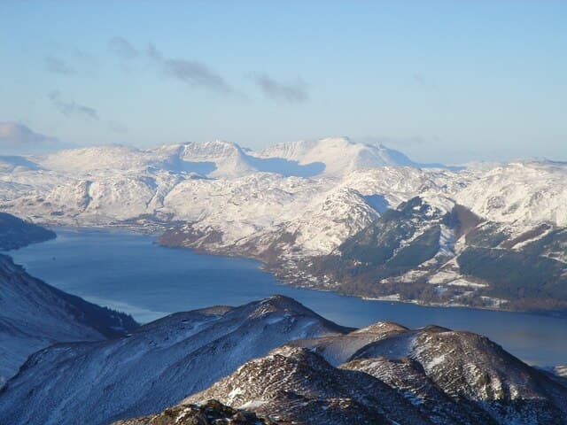
Beinn Bhan is the great wall above Loch Kishorn — the easternmost peak of the Applecross hills and arguably the most dramatic mountains in the North-West Highlands. The east face is a vast tier of north-east-facing corries (Coire na Poite, Coire na Feòla, Coire nan Fhamhair, Coire Attadale) that hold winter climbing routes among the finest in Britain. The summit ridge is broad and the views from it stretch to Skye, the Cuillin and across to the Torridon giants. The standard ascent is gentle; the consequence of straying too far east in cloud is not.
Gaelic: “mountain, fair” · Pronunciation: bine vahn
Quick facts
- Height
- 895.7m/ 2939ft
- Prominence
- 851 m
- Distance
- ~15 km
- Ascent
- ~920 m
- Time
- 4–7 hrs
- Grid ref
- NG803450
- Parking
- NG834422
- Nearest
- Ullapool· Inverness 86km
- Dogs
- Dogs on lead required near livestockDog-friendly guide ↗
Height and prominence cross-checked against the Database of British and Irish Hills (CC BY).
No GPX track yet
Walked this route? Share your track to help other walkers.
Standard route
glen track 20% · rough heather 35% · sandstone plateau 30% · summit cliffs 15%
The usual line starts from the layby on the Tornapress road below the Bealach na Bà. A path leaves the layby and contours into the mouth of Coire nan Fhamhair before climbing the southern flank of the corrie onto the broad plateau. Once on the plateau, follow the rim of the corries north-east to the summit cairn. The descent reverses the line. Strong walkers can extend the day by continuing north-east to Sgùrr a' Chaorachain. Allow 6–7 hours for Beinn Bhan alone.
Terrain
Path in the lower corrie is reasonable but boggy in places. The plateau itself is broad, sandstone-bedded and easy walking — but it ends abruptly at the cliff edge of the east-facing corries. In cloud, navigation discipline matters. The rim is the great viewpoint of the day on a clear afternoon.
In winter
In winter Beinn Bhan is a serious peak. The corries hold major winter routes (Mainreachan-style Grade IV–VI climbs) and the cornices on the corrie rims are notoriously large and unstable. Walkers should stay well clear of the eastern edges; the line of the cliff is not always visible under snow. Check the SAIS Torridon forecast, which covers Applecross.
Kit for this: the winter Munro kit list · which boots take crampons
This hill is in the Torridon SAIS forecast area. Check SAIS forecasts in winter (December–April).
Best time of year
Getting there
- Glasgow4h 46m
- Edinburgh4h 19m
OS maps: OS Landranger 24, OS Explorer 428
Mobile signal: No signal on the approach; line-of-sight south from the summit plateau picks up intermittent EE
Current conditions
Daylight Today
- Sunrise
- 07:54
- Sunset
- 18:24
- Civil dawn
- 07:15
- Civil dusk
- 19:03
NOAA Solar Calculator · 14 October 2026
Pair with
Curated multi-hill combinations from Beinn Bhan.
Around Beinn Bhan on the SCOT network
Getting there, basing yourself, and what to do off the hill.
Getting there: Plockton station
Coastal Wester Ross; Plockton village; Skye Bridge approach
12km from the hill
tripscot.co.uk
On TripSCOTBase yourself in Applecross
Bealach na Bà and the Applecross peninsula
9km from the hill
tripscot.co.uk
On TasteSCOTAfter the hill: Isle of Raasay Distillery
Raasay — new island distillery with rooms; Dun Caan walks from the door
27km from the hill
tastescot.co.uk
Beinn Bhan — common questions
- Is Beinn Bhan a hard climb?
- Beinn Bhan is rated 3/5 (moderately challenging) on the OutdoorSCOT scale. The standard route covers about 15km with 920m of ascent and takes most walkers 4-7 hours. Underfoot: Path in the lower corrie is reasonable but boggy in places.
- What is Beinn Bhan's prominence?
- 851m of prominence. That's the vertical drop from the summit to the col that links Beinn Bhan to the next higher ground.
- Where do I park for Beinn Bhan?
- Most walkers start from NG834422 near Ullapool. Verify the grid reference on an OS map before you set off — space is tight on busy summer weekends.
- When is the best time to climb Beinn Bhan?
- May, June, July, August, September give the most reliable conditions on Beinn Bhan. Beyond that window the high ground turns wintry: carry full mountain kit, be confident navigating, and check the SAIS avalanche forecast for the area.
- Is Beinn Bhan dog-friendly?
- Yes, but dogs must be kept on a lead — there is livestock or ground-nesting bird interest on the route.
- Is there mobile signal on Beinn Bhan?
- No signal on the approach; line-of-sight south from the summit plateau picks up intermittent EE
- Is Beinn Bhan safe in winter?
- In winter Beinn Bhan is a serious peak. The corries hold major winter routes (Mainreachan-style Grade IV–VI climbs) and the cornices on the corrie rims are notoriously large and unstable. Walkers should stay well clear of the eastern edges; the line of the cliff is not always visible under snow. Check the SAIS Torridon forecast, which covers Applecross.
Get the OutdoorSCOT weekly
One email a week — new route, hill and bothy guides, seasonal conditions and the odd hard-won lesson. No spam, unsubscribe in one click.