Corbett · North-West Highlands
Sgurr a' Chaorachain
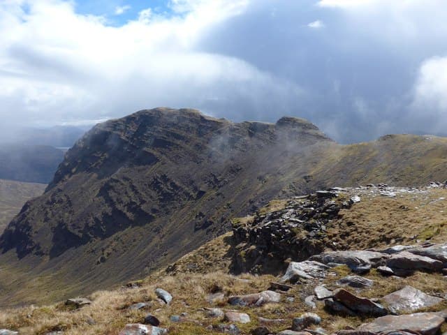
Sgùrr a' Chaorachain is the Applecross Corbett right above the Bealach na Bà — the highest tarred road pass in Britain. Starting at 626m at the summit of the pass means it has by some distance the shortest walk-in of any Corbett, and a relatively modest climb to a summit that gives an extraordinary view across the Inner Sound to Raasay and Skye. The hill also includes the impressive A' Chioch sub-top with its famous east face buttresses — historic Scottish rock climbing ground.
Quick facts
- Height
- 793m/ 2602ft
- Prominence
- 210 m
- Distance
- ~7 km
- Ascent
- ~480 m
- Time
- 2–3 hrs
- Grid ref
- NG796417
- Parking
- NG774417
- Nearest
- Ullapool· Inverness 87km
- Dogs
- Dogs on lead required near livestockDog-friendly guide ↗
Height and prominence cross-checked against the Database of British and Irish Hills (CC BY).
No GPX track yet
Walked this route? Share your track to help other walkers.
Standard route
road top start 10% · rocky ridge 40% · grassy slopes 30% · summit area 20%
Park at the Bealach na Bà summit car park (NG774417). Cross the road and follow an obvious path north-east onto the broad south ridge. The route climbs steadily, passing the radio relay station, and continues to the summit cairn perched above the deep corrie to the east. For the full Applecross horseshoe, continue east to A' Chioch (Grade 2 scrambling on the ridge) before retracing. Allow 3.5–5 hours depending on whether you include A' Chioch.
Terrain
An unusually short and gentle Corbett route thanks to the Bealach na Bà giving 626m of free elevation. The path is good but rocky, crossing Torridonian sandstone slabs. The summit area is broad. The A' Chioch extension involves committing scrambling on a narrow ridge with serious east-facing drops.
In winter
Bealach na Bà is closed by snow gates in heavy winter weather, sometimes for days. When open and the ridge holds firm snow, this counts among the most rewarding short winter days in the area — minimal walk-in, real winter conditions on the summit. Check the pass status before driving up: Highland Council post live updates.
Kit for this: the winter Munro kit list · which boots take crampons
This hill is in the Torridon SAIS forecast area. Check SAIS forecasts in winter (December–April).
Best time of year
Getting there
- Glasgow4h 43m
- Edinburgh4h 16m
OS maps: OS Landranger 24
Mobile signal: EE signal at the Bealach na Bà car park is generally usable; weakens quickly as you descend into corries
Current conditions
Daylight Today
- Sunrise
- 07:54
- Sunset
- 18:24
- Civil dawn
- 07:15
- Civil dusk
- 19:03
NOAA Solar Calculator · 14 October 2026
Pair with
Curated multi-hill combinations from Sgurr a' Chaorachain.
Around Sgurr a' Chaorachain on the SCOT network
Getting there, basing yourself, and what to do off the hill.
Getting there: Plockton station
Coastal Wester Ross; Plockton village; Skye Bridge approach
9km from the hill
tripscot.co.uk
On TripSCOTBase yourself in Applecross
Bealach na Bà and the Applecross peninsula
9km from the hill
tripscot.co.uk
On TasteSCOTAfter the hill: Isle of Raasay Distillery
Raasay — new island distillery with rooms; Dun Caan walks from the door
26km from the hill
tastescot.co.uk
Sgurr a' Chaorachain — common questions
- Is Sgurr a' Chaorachain a hard climb?
- Sgurr a' Chaorachain is rated 2/5 (moderate) on the OutdoorSCOT scale. The standard route covers about 7km with 480m of ascent and takes most walkers 2-3 hours. Underfoot: An unusually short and gentle Corbett route thanks to the Bealach na Bà giving 626m of free elevation.
- What is Sgurr a' Chaorachain's prominence?
- 210m of prominence. That's the vertical drop from the summit to the col that links Sgurr a' Chaorachain to the next higher ground.
- Where do I park for Sgurr a' Chaorachain?
- Most walkers start from NG774417 near Ullapool. Verify the grid reference on an OS map before you set off — space is tight on busy summer weekends.
- When is the best time to climb Sgurr a' Chaorachain?
- May, June, July, August, September give the most reliable conditions on Sgurr a' Chaorachain. Beyond that window the high ground turns wintry: carry full mountain kit, be confident navigating, and check the SAIS avalanche forecast for the area.
- Is Sgurr a' Chaorachain dog-friendly?
- Yes, but dogs must be kept on a lead — there is livestock or ground-nesting bird interest on the route.
- Is there mobile signal on Sgurr a' Chaorachain?
- EE signal at the Bealach na Bà car park is generally usable; weakens quickly as you descend into corries
- Is Sgurr a' Chaorachain safe in winter?
- Bealach na Bà is closed by snow gates in heavy winter weather, sometimes for days. When open and the ridge holds firm snow, this counts among the most rewarding short winter days in the area — minimal walk-in, real winter conditions on the summit. Check the pass status before driving up: Highland Council post live updates.
Get the OutdoorSCOT weekly
One email a week — new route, hill and bothy guides, seasonal conditions and the odd hard-won lesson. No spam, unsubscribe in one click.