Corbett · North-West Highlands
Beinn Damh
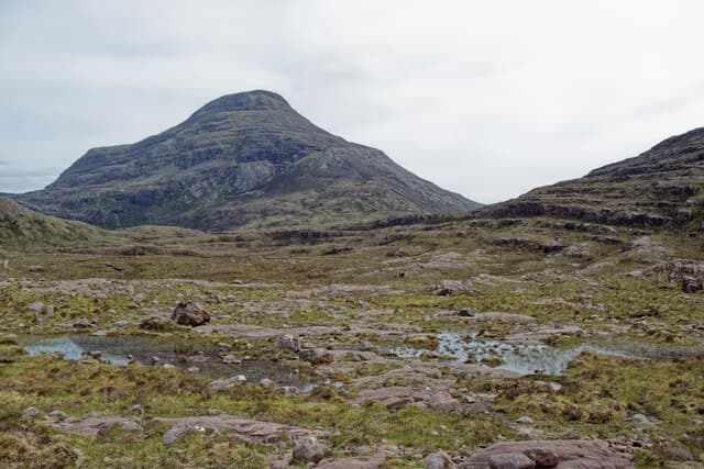
Beinn Damh — 'the stag mountain' — is the elegant 903m Corbett rising directly above Upper Loch Torridon, often regarded as the finest Corbett in the Torridon area. The mountain is built of pale Torridonian sandstone with a quartzite cap, and its south ridge runs in a sweeping line from the loch shore to the summit, giving an unbroken view across to Liathach and Beinn Alligin on the north side of the loch. The ascent is sustained — almost 1000m of climbing in a relatively short distance — and the day rewards with one of the great mountain panoramas in the western Highlands.
Gaelic: “mountain, stag” · Pronunciation: bine dav
Quick facts
- Height
- 902.4m/ 2961ft
- Prominence
- 517 m
- Distance
- 13 km
- Ascent
- 990 m
- Time
- 4–7 hrs
- Grid ref
- NG892502
- Parking
- NG889540
- Nearest city
- Inverness· 77km
- Dogs
- Dogs on lead required near livestockDog-friendly guide ↗
Height and prominence cross-checked against the Database of British and Irish Hills (CC BY).
No GPX track yet
Walked this route? Share your track to help other walkers.
Standard route
stalkers path 25% · rocky ridge 45% · heather slopes 20% · rough descent 10%
Park at the Beinn Damh Hotel layby on the A896 (NG889540). The path heads south through woodland, crosses the Allt Coire Roill via an excellent footbridge and climbs the side of the gorge on a stalkers' path. Above the woodland the path emerges onto open hillside and climbs steadily onto the broad south ridge. The summit is a small rocky cairn at the end of a narrow upper crest. Descent reverses the line. Allow 6.5–7.5 hours.
Terrain
Excellent stalkers' path in the lower section — well-built, easy to follow. The middle section steepens and the path becomes rougher; the upper ridge is firm Torridonian sandstone with mild exposure on the final summit cone. The narrow upper crest has serious drops east into Coire Roill; care needed in high winds.
In winter
A serious winter day. Beinn Damh holds snow on its north-east aspect from December through April; the summit ridge develops cornices and the upper sandstone steps ice up. The hill produces genuine winter accidents from underprepared parties — the route is committed once you're on the upper ridge. Full winter mountain kit and stable forecast required.
This hill is in the Torridon SAIS forecast area. Check SAIS forecasts in winter (December–April).
Best time of year
Getting there
- Glasgow5h 30m
- Edinburgh5h 30m
OS maps: OS Explorer 429
Mobile signal: No usable signal in the Torridon glen or on the hill; brief EE on the A896 toward Shieldaig and at the Beinn Damh Hotel
Current conditions
Daylight Today
- Sunrise
- 04:43
- Sunset
- 22:13
- Civil dawn
- 03:40
- Civil dusk
- 23:16
NOAA Solar Calculator · 13 July 2026
Pair with
Curated multi-hill combinations from Beinn Damh.
Around Beinn Damh on the SCOT network
Getting there, basing yourself, and what to do off the hill.
Beinn Damh — common questions
- How hard is Beinn Damh?
- We grade Beinn Damh at 3/5, which puts it in moderately challenging territory. The usual route is around 13km with 990m of climbing; allow 4-7 hours. Terrain: Excellent stalkers' path in the lower section — well-built, easy to follow.
- How prominent is Beinn Damh?
- Beinn Damh has 517m of topographic prominence — the height of its summit above the highest col connecting it to higher ground.
- Where should I park to climb Beinn Damh?
- Standard parking is at NG889540. Check the parking grid reference on an OS map before travel; informal laybys can fill on summer weekends.
- When should I climb Beinn Damh?
- The standard good-weather months for Beinn Damh are April, May, June, July, August, September, October. Outside those months, expect winter conditions on the high ground — full mountain kit, navigation skills, and a check of the SAIS avalanche forecast for the relevant region.
- Can I bring my dog up Beinn Damh?
- On a lead only — the route crosses ground with livestock or nesting-bird interest.
- What's mobile reception like on Beinn Damh?
- No usable signal in the Torridon glen or on the hill; brief EE on the A896 toward Shieldaig and at the Beinn Damh Hotel
- Is Beinn Damh safe in winter?
- A serious winter day. Beinn Damh holds snow on its north-east aspect from December through April; the summit ridge develops cornices and the upper sandstone steps ice up. The hill produces genuine winter accidents from underprepared parties — the route is committed once you're on the upper ridge. Full winter mountain kit and stable forecast required.
Get the OutdoorSCOT weekly
One email a week — new route, hill and bothy guides, seasonal conditions and the odd hard-won lesson. No spam, unsubscribe in one click.