Corbett · North-West Highlands
Sgorr nan Lochan Uaine
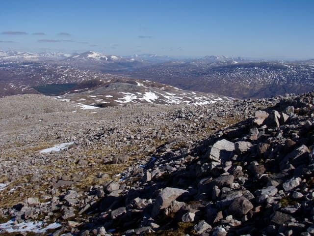
Sgorr nan Lochan Uaine — "the peak of the little green lochans" — sits in the wild Coulin Forest between the Achnashellach hills to the south and the Beinn Eighe massif to the north. At 871m it is one of three Corbetts grouped around the head of Coire Lair, sharing high country with the Munros Sgorr Ruadh, Beinn Liath Mhor and the Corbett Fuar Tholl. The summit is a small rocky peak with a stone-built windshelter, looking down on the cluster of green lochans that give the hill its name.
Gaelic: “sharp peak, of the, small loch” · Pronunciation: skor nan loch-an uaine
Quick facts
- Height
- 871.3m/ 2859ft
- Prominence
- 207 m
- Distance
- 16 km
- Ascent
- 766 m
- Time
- 6–9 hrs
- Grid ref
- NG969531
- Parking
- NH005485
- Nearest
- Ullapool· Inverness 70km
- Dogs
- Dogs on lead required near livestockDog-friendly guide ↗
Height and prominence cross-checked against the Database of British and Irish Hills (CC BY).
No GPX track yet
Walked this route? Share your track to help other walkers.
Standard route
stalkers path 45% · steep grass 25% · rocky hill 20% · summit rocks 10%
Start from the small car park near Achnashellach station on the A890 in Glen Carron. Follow the stalkers path north through the woods and onto the floor of Coire Lair — one of the finest approach corries in the country. After around 5km, branch east up steeper grass and rock onto the south-west shoulder of Sgorr nan Lochan Uaine and follow it to the summit. Around 16km return with 766m of ascent. Many parties combine with neighbouring Fuar Tholl and Sgorr Ruadh.
Terrain
The Coire Lair path is a classic well-built stalkers route, firm and well drained. Off the path the climb onto the south-west shoulder is steep grass with sandstone and quartzite outcrops. The summit area is rocky with narrow gaps between the lochans — care needed in mist where edge-drops appear without warning. The connecting ridges to the Munros involve significant re-ascent and are full mountaineering ground.
In winter
In winter the Coire Lair amphitheatre is one of the great Highland winter venues — Fuar Tholl across the corrie holds famous ice routes. The shoulder onto Sgorr nan Lochan Uaine is an exposed slope that accumulates snow after westerly storms; avalanche risk is genuine. Cornices form along the summit rim above the lochans. A serious winter day requiring full mountaineering kit and competence.
This hill is in the Torridon SAIS forecast area. Check SAIS forecasts in winter (December–April).
Best time of year
Getting there
- Glasgow4h 48m
- Edinburgh4h 14m
OS maps: OS Landranger 25
Mobile signal: No usable signal anywhere in the Fisherfield basin — the surrounding hills block all networks from the Poolewe road to the Shenavall watershed. Coverage returns intermittently on high ridges with line of sight to Loch Maree. Download maps and weather offline before leaving the road.
Current conditions
Daylight Today
- Sunrise
- 04:42
- Sunset
- 22:12
- Civil dawn
- 03:39
- Civil dusk
- 23:16
NOAA Solar Calculator · 13 July 2026
Pair with
Curated multi-hill combinations from Sgorr nan Lochan Uaine.
Around Sgorr nan Lochan Uaine on the SCOT network
Getting there, basing yourself, and what to do off the hill.
Sgorr nan Lochan Uaine — common questions
- How difficult is Sgorr nan Lochan Uaine?
- Sgorr nan Lochan Uaine carries a 5/5 (very challenging) grade on the OutdoorSCOT scale. Count on about 16km, 766m of ascent and a 6-9 hour day on the standard route. Underfoot: The Coire Lair path is a classic well-built stalkers route, firm and well drained.
- What is Sgorr nan Lochan Uaine's prominence?
- 207m of prominence. That's the vertical drop from the summit to the col that links Sgorr nan Lochan Uaine to the next higher ground.
- Where do I park for Sgorr nan Lochan Uaine?
- Most walkers start from NH005485 near Ullapool. Verify the grid reference on an OS map before you set off — space is tight on busy summer weekends.
- When is the best time to climb Sgorr nan Lochan Uaine?
- May, June, July, August, September give the most reliable conditions on Sgorr nan Lochan Uaine. Beyond that window the high ground turns wintry: carry full mountain kit, be confident navigating, and check the SAIS avalanche forecast for the area.
- Is Sgorr nan Lochan Uaine dog-friendly?
- Yes, but dogs must be kept on a lead — there is livestock or ground-nesting bird interest on the route.
- Is there mobile signal on Sgorr nan Lochan Uaine?
- No usable signal anywhere in the Fisherfield basin — the surrounding hills block all networks from the Poolewe road to the Shenavall watershed. Coverage returns intermittently on high ridges with line of sight to Loch Maree. Download maps and weather offline before leaving the road.
- Is Sgorr nan Lochan Uaine safe in winter?
- In winter the Coire Lair amphitheatre is one of the great Highland winter venues — Fuar Tholl across the corrie holds famous ice routes. The shoulder onto Sgorr nan Lochan Uaine is an exposed slope that accumulates snow after westerly storms; avalanche risk is genuine. Cornices form along the summit rim above the lochans. A serious winter day requiring full mountaineering kit and competence.
Get the OutdoorSCOT weekly
One email a week — new route, hill and bothy guides, seasonal conditions and the odd hard-won lesson. No spam, unsubscribe in one click.