Munro · North-West Highlands
Sgurr a' Chaorachain
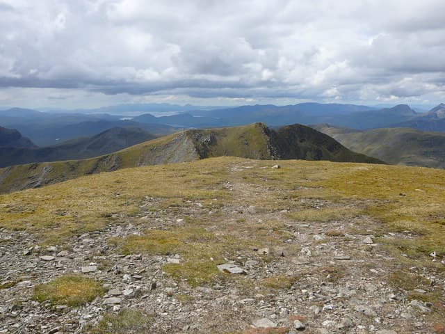
Sgurr a' Chaorachain (1053m) — not to be confused with the smaller Applecross Corbett of the same name — is the higher of the two Achnashellach Munros, paired with Sgurr Choinnich at the head of Strath Conon. The peak sits above the dramatic Coire Toll an Lochain and gives one of the great seaward views in the Highlands, taking in Liathach, Beinn Eighe and the Torridon group to the west. The Bidean an Eoin Deirg ridge eastwards is a fine subsidiary scramble.
Quick facts
- Height
- 1053m/ 3455ft
- Prominence
- 568 m
- Distance
- 18 km
- Ascent
- 927 m
- Time
- 6–10 hrs
- Grid ref
- NH087447
- Parking
- NH039492
- Nearest
- Ullapool· Inverness 58km
- Dogs
- Dogs on lead required near livestockDog-friendly guide ↗
Height and prominence cross-checked against the Database of British and Irish Hills (CC BY).
No GPX track yet
Walked this route? Share your track to help other walkers.
Standard route
Stalkers path 40% · Open hillside 35% · Rocky summit 25%
Park at Craig on the A890, just west of Achnashellach station. Take the well-built stalkers' path up the Allt a' Chonais — one of the longest sustained stalkers' paths in Scotland — into the heart of the mountains. From the high glen turn north up Coire Choinnich to the bealach between Sgurr Choinnich and Sgurr a' Chaorachain, then turn east along the rocky ridge to Sgurr a' Chaorachain. Most parties combine both Munros. Around 22km with 1300m of ascent for the pair.
Terrain
The Allt a' Chonais stalkers' path is excellent restored work for most of its length — firm, well-drained and gently graded. The bridge over the river before the climb to the bealach can be slippery. The climb up Coire Choinnich is rough scree and short grass. The summit ridge of Sgurr a' Chaorachain is broad and easy. The eastward extension to Bidean an Eoin Deirg is a narrow rocky scramble that should not be missed in good weather.
In winter
A serious Achnashellach winter day. The Coire Choinnich headwall takes serious avalanche loading from south-westerly storms. Cornices build along the north edge of the connecting ridge through the season. The Bidean an Eoin Deirg extension becomes a Grade I winter scramble. The A890 at Achnashellach is usually open but the station-area lay-by can be drifted. SAIS Torridon and Northern Highlands apply. Allow extra time — long approach in shortened daylight.
This hill is in the Torridon SAIS forecast area. Check SAIS forecasts in winter (December–April).
Best time of year
Getting there
- Glasgow4h 35m
- Edinburgh4h 58m
OS maps: OS Landranger 25
Mobile signal: No bars above 700m in the Achnashellach Forest. The A890 near Achnasheen has occasional 4G. Download maps ahead of the drive.
Current conditions
Daylight Today
- Sunrise
- 04:59
- Sunset
- 21:55
- Civil dawn
- 04:02
- Civil dusk
- 22:53
NOAA Solar Calculator · 23 July 2026
Pair with
Curated multi-hill combinations from Sgurr a' Chaorachain.
Around Sgurr a' Chaorachain on the SCOT network
Getting there, basing yourself, and what to do off the hill.
Sgurr a' Chaorachain — common questions
- Is Sgurr a' Chaorachain a hard climb?
- Sgurr a' Chaorachain is rated 5/5 (very challenging) on the OutdoorSCOT scale. The standard route covers about 18km with 927m of ascent and takes most walkers 6-10 hours. Underfoot: The Allt a' Chonais stalkers' path is excellent restored work for most of its length — firm, well-drained and gently graded.
- What is Sgurr a' Chaorachain's prominence?
- 568m of prominence. That's the vertical drop from the summit to the col that links Sgurr a' Chaorachain to the next higher ground.
- Where do I park for Sgurr a' Chaorachain?
- Most walkers start from NH039492 near Ullapool. Verify the grid reference on an OS map before you set off — space is tight on busy summer weekends.
- When is the best time to climb Sgurr a' Chaorachain?
- May, June, July, August, September, October give the most reliable conditions on Sgurr a' Chaorachain. Beyond that window the high ground turns wintry: carry full mountain kit, be confident navigating, and check the SAIS avalanche forecast for the area.
- Is Sgurr a' Chaorachain dog-friendly?
- Yes, but dogs must be kept on a lead — there is livestock or ground-nesting bird interest on the route.
- Is there mobile signal on Sgurr a' Chaorachain?
- No bars above 700m in the Achnashellach Forest. The A890 near Achnasheen has occasional 4G. Download maps ahead of the drive.
- Is Sgurr a' Chaorachain safe in winter?
- A serious Achnashellach winter day. The Coire Choinnich headwall takes serious avalanche loading from south-westerly storms. Cornices build along the north edge of the connecting ridge through the season. The Bidean an Eoin Deirg extension becomes a Grade I winter scramble. The A890 at Achnashellach is usually open but the station-area lay-by can be drifted. SAIS Torridon and Northern Highlands apply. Allow extra time — long approach in shortened daylight.
Get the OutdoorSCOT weekly
One email a week — new route, hill and bothy guides, seasonal conditions and the odd hard-won lesson. No spam, unsubscribe in one click.