Munro · North-West Highlands
Maoile Lunndaidh
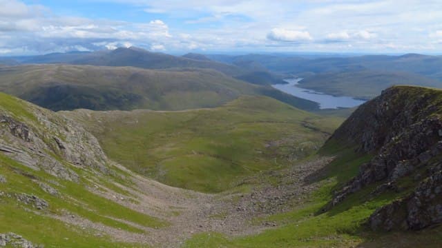
Maoile Lunndaidh (1005m) is the easternmost of the four Strathconon Munros — a vast, flat-topped plateau hill at the head of Gleann Fhiodhaig deep in the Achnashellach country. The summit area is exceptional in size, a great mossy tableland whose true high point can be elusive in cloud. Most parties tackle the hill in tandem with Sgùrr a' Chaorachain and Sgùrr Choinnich on a long round, or as a standalone via the long but excellent stalkers' path from Craig.
Quick facts
- Height
- 1004.9m/ 3297ft
- Prominence
- 11 m
- Distance
- 17 km
- Ascent
- 884 m
- Time
- 6–9 hrs
- Grid ref
- NH135458
- Parking
- NH039492
- Nearest
- Ullapool· Inverness 53km
- Dogs
- Dogs on lead required near livestockDog-friendly guide ↗
Height and prominence cross-checked against the Database of British and Irish Hills (CC BY).
No GPX track yet
Walked this route? Share your track to help other walkers.
Standard route
Glen track 40% · Open moorland 35% · Summit plateau 25%
Start from Craig on the A890 west of Achnashellach. Walk west along the stalkers' path up the Allt a' Chonais, then continue past the bridges to the head of the glen. From the bealach climb the broad north-west shoulder of Maoile Lunndaidh onto the plateau. Navigate carefully across the broad mossy summit to the cairn (the blade of rock at the high point). Often extended to Sgùrr a' Chaorachain and Sgùrr Choinnich. Around 24km with 1100m of ascent for the standalone Munro.
Terrain
The Allt a' Chonais stalkers' path from Craig is excellent restored pitching for most of its length. Off the path the ground is rough boggy moor. The climb onto the Maoile Lunndaidh plateau is steady on grass and short turf. The summit plateau is one of the largest in Scotland — easily several square kilometres of broad mossy turf and gravel, with no real high point in sight. The blade of rock marking the cairn is small.
In winter
A serious winter day on a vast featureless plateau. Whiteout navigation across the summit area in poor visibility is a real challenge. Cornicing along the corrie rims (Toll a' Choin, Fuar-tholl Mòr) is consistent through the season. The Craig access lay-by stays accessible but the side track in can drift. Phone signal absent throughout. SAIS Northern Highlands applies.
This hill is in the Torridon SAIS forecast area. Check SAIS forecasts in winter (December–April).
Best time of year
Getting there
- Glasgow4h 34m
- Edinburgh4h 56m
OS maps: OS Landranger 25
Mobile signal: Zero signal above 700m on the Maoile Lunndaidh plateau. The A890 corridor has occasional signal. Fetch maps before leaving Achnasheen.
Current conditions
Daylight Today
- Sunrise
- 04:59
- Sunset
- 21:55
- Civil dawn
- 04:02
- Civil dusk
- 22:52
NOAA Solar Calculator · 23 July 2026
Around Maoile Lunndaidh on the SCOT network
Getting there, basing yourself, and what to do off the hill.
Maoile Lunndaidh — common questions
- Is Maoile Lunndaidh a hard climb?
- Maoile Lunndaidh is rated 5/5 (very challenging) on the OutdoorSCOT scale. The standard route covers about 17km with 884m of ascent and takes most walkers 6-9 hours. Ground conditions: The Allt a' Chonais stalkers' path from Craig is excellent restored pitching for most of its length.
- How much drop does Maoile Lunndaidh have?
- The drop is 11m: measured from the summit of Maoile Lunndaidh down to the saddle joining it to higher terrain.
- Where's the parking for Maoile Lunndaidh?
- Park at NH039492 near Ullapool. Double-check the grid reference on an OS map first; informal laybys here fill early in high season.
- What's the best month to climb Maoile Lunndaidh?
- Aim for May, June, July, August, September, October on Maoile Lunndaidh. In the remaining months treat it as a winter hill — full kit, solid navigation, and a look at the relevant SAIS avalanche forecast before you go.
- Can dogs go up Maoile Lunndaidh?
- Dogs are fine on a lead. The route passes livestock or ground-nesting bird habitat, so keep them close throughout.
- Will I get phone signal on Maoile Lunndaidh?
- Zero signal above 700m on the Maoile Lunndaidh plateau. The A890 corridor has occasional signal. Fetch maps before leaving Achnasheen.
- Is Maoile Lunndaidh safe in winter?
- A serious winter day on a vast featureless plateau. Whiteout navigation across the summit area in poor visibility is a real challenge. Cornicing along the corrie rims (Toll a' Choin, Fuar-tholl Mòr) is consistent through the season. The Craig access lay-by stays accessible but the side track in can drift. Phone signal absent throughout. SAIS Northern Highlands applies.
Get the OutdoorSCOT weekly
One email a week — new route, hill and bothy guides, seasonal conditions and the odd hard-won lesson. No spam, unsubscribe in one click.