Graham · North-West Highlands
Beinn Mheadhoin
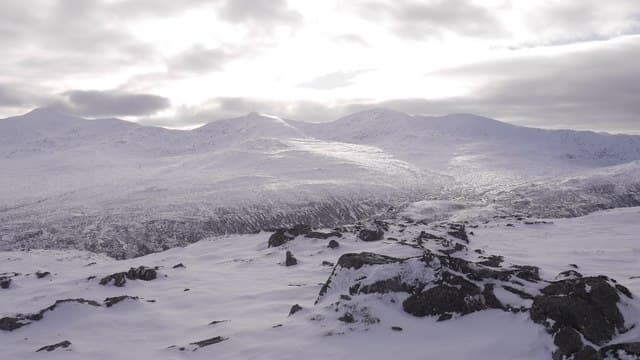
Beinn Mheadhoin (664m) — the middle hill — rises above Strathconon in the NH24 square, a sandstone outlier west of Garve. The rock rib just west of its small cairn provides the truest high point, looking out over wild Strathconon to An Sidhean and the headwaters of the Meig.
Quick facts
- Height
- 664.3m/ 2179ft
- Prominence
- 217 m
- Distance
- 13 km
- Ascent
- 544 m
- Time
- 4–6 hrs
- Grid ref
- NH258477
- Parking
- NH226472
- Nearest city
- Inverness· 41km
- Dogs
- Dogs on lead required near livestockDog-friendly guide ↗
Height and prominence cross-checked against the Database of British and Irish Hills (CC BY).
No GPX track yet
Walked this route? Share your track to help other walkers.
Standard route
heather moorland 65% · grass slopes 25% · rocky outcrops 10%
Start from the road end at Inverchoran near Loch Beannacharain. Follow the estate track south-west along the Allt an Eas Bhuidhe before striking up steeply onto the broad east shoulder. The angle eases on a heathery rib leading to the rock rib and small cairn; descend by the same line or extend west along the watershed.
Terrain
Estate track for the first three kilometres, then pathless heather and tussock on the east shoulder. The rocky rib at the top requires care in mist — the true high point lies a few metres west of the cairn marker.
In winter
Strathconon catches Atlantic snow but thaws fast at this altitude. Beinn Mheadhoin's north-east corrie holds late drifts and can be icy after rain-freeze cycles. The hill is remote enough that a slip far from the track becomes serious; carry axe and spikes from December through March.
This hill is in the Torridon SAIS forecast area. Check SAIS forecasts in winter (December–April).
Best time of year
Getting there
- Glasgow4h 34m
- Edinburgh4h 51m
OS maps: OS Landranger 25
Mobile signal: Poor. Remote north-west Highlands; nothing works dependably here.
Current conditions
Daylight Today
- Sunrise
- 04:41
- Sunset
- 22:10
- Civil dawn
- 03:37
- Civil dusk
- 23:13
NOAA Solar Calculator · 13 July 2026
Around Beinn Mheadhoin on the SCOT network
Getting there, basing yourself, and what to do off the hill.
Getting there: Dingwall station
Ben Wyvis approach; Easter Ross; junction for Kyle and Far North lines
31km from the hill
tripscot.co.uk
On TripSCOTBase yourself in Inverness
Highland capital — gateway to Cairngorms, Affric, Far North
41km from the hill
tripscot.co.uk
On TasteSCOTAfter the hill: Glen Ord
Muir of Ord — Black Isle distillery; the Singleton range's Highland anchor
27km from the hill
tastescot.co.uk
Beinn Mheadhoin — common questions
- How hard is Beinn Mheadhoin?
- We grade Beinn Mheadhoin at 4/5, which puts it in challenging territory. The usual route is around 13km with 544m of climbing; allow 4-6 hours. Underfoot: Estate track for the first three kilometres, then pathless heather and tussock on the east shoulder.
- What is Beinn Mheadhoin's prominence?
- 217m of prominence. That's the vertical drop from the summit to the col that links Beinn Mheadhoin to the next higher ground.
- Where do I park for Beinn Mheadhoin?
- Most walkers start from NH226472. Verify the grid reference on an OS map before you set off — space is tight on busy summer weekends.
- When is the best time to climb Beinn Mheadhoin?
- March, April, May, June, July, August, September, October, November give the most reliable conditions on Beinn Mheadhoin. Beyond that window the high ground turns wintry: carry full mountain kit, be confident navigating, and check the SAIS avalanche forecast for the area.
- Is Beinn Mheadhoin dog-friendly?
- Yes, but dogs must be kept on a lead — there is livestock or ground-nesting bird interest on the route.
- Is there mobile signal on Beinn Mheadhoin?
- Poor. Remote north-west Highlands; nothing works dependably here.
- Is Beinn Mheadhoin safe in winter?
- Strathconon catches Atlantic snow but thaws fast at this altitude. Beinn Mheadhoin's north-east corrie holds late drifts and can be icy after rain-freeze cycles. The hill is remote enough that a slip far from the track becomes serious; carry axe and spikes from December through March.
Get the OutdoorSCOT weekly
One email a week — new route, hill and bothy guides, seasonal conditions and the odd hard-won lesson. No spam, unsubscribe in one click.