Graham · North-West Highlands
Meall a' Chaorainn
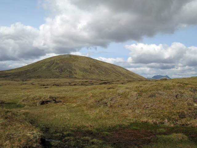
Meall a' Chaorainn (705m) — the rowan hill — sits at NH13 in the rolling moorland north of Achnasheen, between Loch a' Chroisg and the head of Loch Fannich. A small cairn tops a domed grassy summit with a fine view east into the Fannichs and west to An Teallach's pinnacled silhouette. One of several Scottish hills sharing this name — this is the Achnasheen example.
Quick facts
- Height
- 705m/ 2313ft
- Prominence
- 189 m
- Distance
- 13 km
- Ascent
- 578 m
- Time
- 4–6 hrs
- Grid ref
- NH136604
- Nearest
- Ullapool· Inverness 55km
- Dogs
- Dogs on lead required near livestockDog-friendly guide ↗
Height and prominence cross-checked against the Database of British and Irish Hills (CC BY).
No GPX track yet
Walked this route? Share your track to help other walkers.
Standard route
heather moorland 60% · grassy slopes 25% · rocky summit 15%
From the A832 west of Achnasheen, take the estate track north toward Lochan Fada area then strike up the south-east shoulder on faint deer trods. 13km return on the standard line, 578m climbed. No formal parking; the railway lay-by near Achnasheen station is a useful start point. The hill makes a quiet alternative to the Fannichs immediately to the north.
Terrain
Lower ground is wet deer-grass and tussock with peat hags between heather strips. The middle slopes firm onto stony moss and the upper dome carries short bilberry. The cairn is small and easily missed in cloud; aim for the highest GPS waypoint on the broad shoulder.
In winter
Sheltered partly from west-coast storms by the An Teallach massif but still picks up significant Atlantic snowfall and rime on the upper dome. SAIS Northern Highlands forecast covers the area directly. The track approach can drift over in heavy events, leaving long postholing on the return. December daylight is below seven hours here.
This hill is in the Torridon SAIS forecast area. Check SAIS forecasts in winter (December–April).
Best time of year
Getting there
- Glasgow4h 51m
- Edinburgh4h 11m
OS maps: OS Landranger 25, OS Explorer 433
Mobile signal: Poor. Limited coverage in the Achnasheen/Loch a' Chroisg corridor on most networks.
Current conditions
Daylight Today
- Sunrise
- 04:41
- Sunset
- 22:12
- Civil dawn
- 03:37
- Civil dusk
- 23:16
NOAA Solar Calculator · 13 July 2026
Around Meall a' Chaorainn on the SCOT network
Getting there, basing yourself, and what to do off the hill.
Meall a' Chaorainn — common questions
- What difficulty is Meall a' Chaorainn?
- On the OutdoorSCOT scale, Meall a' Chaorainn comes in at 4/5 — challenging. Expect roughly 13km and 578m of ascent on the usual route — 4-6 hours for most parties. Ground conditions: Lower ground is wet deer-grass and tussock with peat hags between heather strips.
- How much drop does Meall a' Chaorainn have?
- The drop is 189m: measured from the summit of Meall a' Chaorainn down to the saddle joining it to higher terrain.
- What's the best month to climb Meall a' Chaorainn?
- Aim for May, June, July, August, September on Meall a' Chaorainn. In the remaining months treat it as a winter hill — full kit, solid navigation, and a look at the relevant SAIS avalanche forecast before you go.
- Can dogs go up Meall a' Chaorainn?
- Dogs are fine on a lead. The route passes livestock or ground-nesting bird habitat, so keep them close throughout.
- Will I get phone signal on Meall a' Chaorainn?
- Poor. Limited coverage in the Achnasheen/Loch a' Chroisg corridor on most networks.
- Is Meall a' Chaorainn safe in winter?
- Sheltered partly from west-coast storms by the An Teallach massif but still picks up significant Atlantic snowfall and rime on the upper dome. SAIS Northern Highlands forecast covers the area directly. The track approach can drift over in heavy events, leaving long postholing on the return. December daylight is below seven hours here.
Get the OutdoorSCOT weekly
One email a week — new route, hill and bothy guides, seasonal conditions and the odd hard-won lesson. No spam, unsubscribe in one click.