Munro · North-West Highlands
Fionn Bheinn
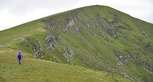
Fionn Bheinn (933m) — "white hill" — is a solitary Munro rising directly above Achnasheen on the A832, well separated from the Fannaichs to the north. The hill is one of the more accessible Northern Highlands Munros — barely a 4km direct ascent from the village. Despite the unassuming profile the summit gives unexpectedly far-reaching views across the Northern Highlands, including a fine outlook to the Torridon hills.
Quick facts
- Height
- 933m/ 3061ft
- Prominence
- 658 m
- Distance
- ~9 km
- Ascent
- ~850 m
- Time
- 6–9 hrs
- Grid ref
- NH147621
- Parking
- NH164587
- Nearest
- Ullapool· Inverness 54km
- Dogs
- Dogs on lead required near livestockDog-friendly guide ↗
Height and prominence cross-checked against the Database of British and Irish Hills (CC BY).
No GPX track yet
Walked this route? Share your track to help other walkers.
Standard route
Roadside path 20% · Open hillside 50% · Summit 30%
Park at Achnasheen on the A832 (small lay-by; the village has a station on the Inverness–Kyle line). Walk north on the rough estate track up the Allt Achadh na Sine, then climb the broad south ridge of Fionn Bheinn directly to the trig pillar at the summit. Return reverses the line. Around 9km return with 850m of ascent — a short, steep day with no real path above the lower slopes.
Terrain
The lower estate track is firm but the climb above is rough heathery hillside without a clear path. Above 700m the going becomes short grass and broken rock; a trig pillar marks the summit. Reverse the line on the descent; pace carefully on the steep grass.
In winter
A reasonably accessible Northern Highlands winter Munro, often used as a quick day when the bigger Fannaichs are weathered out. The summit area is fully exposed to westerly weather. The A832 corridor stays gritted at Achnasheen. Phone signal is reasonable at the village.
Kit for this: the winter Munro kit list · which boots take crampons
Best time of year
Getting there
- Glasgow4h 52m
- Edinburgh4h 12m
OS maps: OS Landranger 20
Mobile signal: Reasonable signal at Achnasheen — good 4G on the A832. Reception tails off above 700m on Fionn Bheinn. Stash maps before departing Achnasheen.
Current conditions
Daylight Today
- Sunrise
- 08:10
- Sunset
- 18:00
- Civil dawn
- 07:29
- Civil dusk
- 18:40
NOAA Solar Calculator · 22 October 2026
Pair with
Curated multi-hill combinations from Fionn Bheinn.
Around Fionn Bheinn on the SCOT network
Getting there, basing yourself, and what to do off the hill.
Fionn Bheinn — common questions
- How hard is Fionn Bheinn?
- We grade Fionn Bheinn at 5/5, which puts it in very challenging territory. The usual route is around 9km with 850m of climbing; allow 6-9 hours. Underfoot: The lower estate track is firm but the climb above is rough heathery hillside without a clear path.
- What is Fionn Bheinn's prominence?
- 658m of prominence. That's the vertical drop from the summit to the col that links Fionn Bheinn to the next higher ground.
- Where do I park for Fionn Bheinn?
- Most walkers start from NH164587 near Ullapool. Verify the grid reference on an OS map before you set off — space is tight on busy summer weekends.
- When is the best time to climb Fionn Bheinn?
- May, June, July, August, September give the most reliable conditions on Fionn Bheinn. Beyond that window the high ground turns wintry: carry full mountain kit, be confident navigating, and check the SAIS avalanche forecast for the area.
- Is Fionn Bheinn dog-friendly?
- Yes, but dogs must be kept on a lead — there is livestock or ground-nesting bird interest on the route.
- Is there mobile signal on Fionn Bheinn?
- Reasonable signal at Achnasheen — good 4G on the A832. Reception tails off above 700m on Fionn Bheinn. Stash maps before departing Achnasheen.
- Is Fionn Bheinn safe in winter?
- A reasonably accessible Northern Highlands winter Munro, often used as a quick day when the bigger Fannaichs are weathered out. The summit area is fully exposed to westerly weather. The A832 corridor stays gritted at Achnasheen. Phone signal is reasonable at the village.
Get the OutdoorSCOT weekly
One email a week — new route, hill and bothy guides, seasonal conditions and the odd hard-won lesson. No spam, unsubscribe in one click.