Munro · North-West Highlands
Sgurr Mor
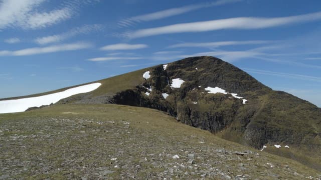
Sgurr Mor — "big peak" — is the 1109m Munro at the heart of the Fannaichs, the long range of seven Munros between Loch Glascarnoch and Loch Fannich north of Ullapool. With 914m of prominence it stands clear of its neighbours and gives a striking view down its northern corries to the loch system below. The summit is a large cairn on a small rocky platform — the high point of one of the great undulating Highland ridges.
Gaelic: “sharp peak, big” · Pronunciation: skoor more
Quick facts
- Height
- 1108.9m/ 3638ft
- Prominence
- 914 m
- Distance
- 18 km
- Ascent
- 976 m
- Time
- 7–10 hrs
- Grid ref
- NH203718
- Parking
- NH273754
- Nearest
- Ullapool· Inverness 53km
- Dogs
- Dogs on lead required near livestockDog-friendly guide ↗
Height and prominence cross-checked against the Database of British and Irish Hills (CC BY).
No GPX track yet
Walked this route? Share your track to help other walkers.
Standard route
Loch-side track 30% · Open hillside 35% · Summit ridge 35%
The standard line is from the A835 at Loch Droma, taking the path south up the Allt a' Choire Bhuig to the Bealach Coire Mor, then climbing east up the broad ridge to Sgurr Mor. Around 18km return with 976m of ascent. Most parties traverse onto neighbouring Meall Gorm and Beinn Liath Mor Fannaich for a multi-Munro Fannaichs round.
Terrain
The Loch Droma path is firm gravel onto the bealach. The Fannaich ridges are short grass and stones with intermittent path; broad walking with no exposure. The summit cone is rocky with the cairn on a small platform. The connecting ridges undulate over a series of subsidiary tops — significant cumulative ascent over the full traverse.
In winter
A serious winter Munro. The Fannaichs catch full Atlantic loading; cornices form on the north sides of all the major summits. The Sgurr Mor north face holds Grade I-III winter routes. The A835 is gritted and reliable. SAIS Northern Highlands applies.
This hill is in the Torridon SAIS forecast area. Check SAIS forecasts in winter (December–April).
Best time of year
Getting there
- Glasgow4h 2m
- Edinburgh4h 18m
OS maps: OS Landranger 20
Mobile signal: Zero signal above 700m in the Fannaich range. Garve or Ullapool has 4G. The Loch Fannich approaches are completely out of range.
Current conditions
Daylight Today
- Sunrise
- 04:57
- Sunset
- 21:56
- Civil dawn
- 03:59
- Civil dusk
- 22:54
NOAA Solar Calculator · 23 July 2026
Pair with
Curated multi-hill combinations from Sgurr Mor.
Around Sgurr Mor on the SCOT network
Getting there, basing yourself, and what to do off the hill.
Sgurr Mor — common questions
- Is Sgurr Mor a hard climb?
- Sgurr Mor is rated 3/5 (moderately challenging) on the OutdoorSCOT scale. The standard route covers about 18km with 976m of ascent and takes most walkers 7-10 hours. Underfoot: The Loch Droma path is firm gravel onto the bealach.
- What is Sgurr Mor's prominence?
- 914m of prominence. That's the vertical drop from the summit to the col that links Sgurr Mor to the next higher ground.
- Where do I park for Sgurr Mor?
- Most walkers start from NH273754 near Ullapool. Verify the grid reference on an OS map before you set off — space is tight on busy summer weekends.
- When is the best time to climb Sgurr Mor?
- May, June, July, August, September give the most reliable conditions on Sgurr Mor. Beyond that window the high ground turns wintry: carry full mountain kit, be confident navigating, and check the SAIS avalanche forecast for the area.
- Is Sgurr Mor dog-friendly?
- Yes, but dogs must be kept on a lead — there is livestock or ground-nesting bird interest on the route.
- Is there mobile signal on Sgurr Mor?
- Zero signal above 700m in the Fannaich range. Garve or Ullapool has 4G. The Loch Fannich approaches are completely out of range.
- Is Sgurr Mor safe in winter?
- A serious winter Munro. The Fannaichs catch full Atlantic loading; cornices form on the north sides of all the major summits. The Sgurr Mor north face holds Grade I-III winter routes. The A835 is gritted and reliable. SAIS Northern Highlands applies.
Get the OutdoorSCOT weekly
One email a week — new route, hill and bothy guides, seasonal conditions and the odd hard-won lesson. No spam, unsubscribe in one click.