Munro · North-West Highlands
Sgurr nan Clach Geala
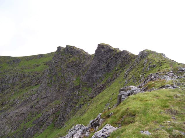
Sgurr nan Clach Geala — "peak of the white stones" — is the 1093m Munro widely considered the finest summit in the Fannaichs north of Ullapool. The hill earns its name from the pale quartzite cap that crowns the upper mountain, contrasting with the darker schist of the lower slopes. The north-east face is one of the most dramatic Munro corrie walls in the area, holding Grade III-IV winter routes. The summit is a small cairn on a narrow rocky crest.
Quick facts
- Height
- 1093.4m/ 3587ft
- Prominence
- 229 m
- Distance
- 18 km
- Ascent
- 962 m
- Time
- 7–10 hrs
- Grid ref
- NH184714
- Parking
- NH162761
- Nearest
- Ullapool· Inverness 55km
- Dogs
- Dogs on lead required near livestockDog-friendly guide ↗
Height and prominence cross-checked against the Database of British and Irish Hills (CC BY).
No GPX track yet
Walked this route? Share your track to help other walkers.
Standard route
Dam road / loch-side track 30% · Open hillside 35% · Rocky ridge / summit 35%
The standard line is from the A832 at Braemore Junction, taking the long path south up the Allt Breabaig glen to the bealach below Sgurr nan Clach Geala. Climb the north ridge to the summit, then continue south to Sgurr nan Each or Meall a' Chrasgaidh for a multi-Munro round. Around 18km return with 962m of ascent for the single summit; longer rounds add 5-10km.
Terrain
The Allt Breabaig stalkers path is firm peat through the lower glen. The pull onto the ridge crosses steep grass and broken rock bands. The summit crest is short and rocky with serious exposure above Coire Mhoir; one tricky section near the top. The connecting ridges to other Fannaich Munros are broad short turf.
In winter
A serious winter Munro. The north-east face is a major climbing venue (Grade III-V routes including the classic Skyscraper Buttress). Cornicing along the summit ridge is consistent through the season. Avalanche risk on the corries after westerly storms. The A832 corridor is gritted. SAIS Northern Highlands applies.
This hill is in the Torridon SAIS forecast area. Check SAIS forecasts in winter (December–April).
Best time of year
Getting there
- Glasgow4h 2m
- Edinburgh4h 19m
OS maps: OS Landranger 20
Mobile signal: Nothing above 700m. Garve or Achnasheen has the nearest coverage. The Fannaich hills are consistently out of range — download maps before the drive.
Current conditions
Daylight Today
- Sunrise
- 04:57
- Sunset
- 21:56
- Civil dawn
- 03:59
- Civil dusk
- 22:54
NOAA Solar Calculator · 23 July 2026
Pair with
Curated multi-hill combinations from Sgurr nan Clach Geala.
On a long-distance route
Sgurr nan Clach Geala sits within 5km of these named long-distance walks — useful for trail-pack rest days or section extensions.
Around Sgurr nan Clach Geala on the SCOT network
Getting there, basing yourself, and what to do off the hill.
Sgurr nan Clach Geala — common questions
- What difficulty is Sgurr nan Clach Geala?
- On the OutdoorSCOT scale, Sgurr nan Clach Geala comes in at 5/5 — very challenging. Expect roughly 18km and 962m of ascent on the usual route — 7-10 hours for most parties. Ground conditions: The Allt Breabaig stalkers path is firm peat through the lower glen.
- How much drop does Sgurr nan Clach Geala have?
- The drop is 229m: measured from the summit of Sgurr nan Clach Geala down to the saddle joining it to higher terrain.
- Where's the parking for Sgurr nan Clach Geala?
- Park at NH162761 near Ullapool. Double-check the grid reference on an OS map first; informal laybys here fill early in high season.
- What's the best month to climb Sgurr nan Clach Geala?
- Aim for May, June, July, August, September on Sgurr nan Clach Geala. In the remaining months treat it as a winter hill — full kit, solid navigation, and a look at the relevant SAIS avalanche forecast before you go.
- Can dogs go up Sgurr nan Clach Geala?
- Dogs are fine on a lead. The route passes livestock or ground-nesting bird habitat, so keep them close throughout.
- Will I get phone signal on Sgurr nan Clach Geala?
- Nothing above 700m. Garve or Achnasheen has the nearest coverage. The Fannaich hills are consistently out of range — download maps before the drive.
- Is Sgurr nan Clach Geala safe in winter?
- A serious winter Munro. The north-east face is a major climbing venue (Grade III-V routes including the classic Skyscraper Buttress). Cornicing along the summit ridge is consistent through the season. Avalanche risk on the corries after westerly storms. The A832 corridor is gritted. SAIS Northern Highlands applies.
Get the OutdoorSCOT weekly
One email a week — new route, hill and bothy guides, seasonal conditions and the odd hard-won lesson. No spam, unsubscribe in one click.