Graham · Central Highlands
An Cruachan
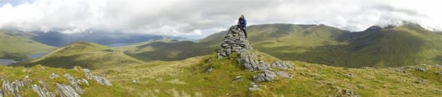
An Cruachan (705m) at NH09 sits between Loch Mullardoch and Glen Strathfarrar, a large-cairned grass-and-rock summit in the broad bealach country of the central Highlands. The view from the cairn stretches across Mullardoch's long mirror to the An Riabhachan ridge and east toward the great inland forests of Affric. This is heart-of-the-Highlands walking — empty, lonely and big-skied.
Quick facts
- Height
- 705m/ 2313ft
- Prominence
- 237 m
- Distance
- 13 km
- Ascent
- 578 m
- Time
- 4–6 hrs
- Grid ref
- NH093358
- Parking
- NH091348
- Nearest city
- Inverness· 58km
- Dogs
- Dogs on lead required near livestockDog-friendly guide ↗
Height and prominence cross-checked against the Database of British and Irish Hills (CC BY).
No GPX track yet
Walked this route? Share your track to help other walkers.
Standard route
heather moorland 55% · grass and bracken 30% · rocky outcrops 15%
From Glen Strathfarrar (NH091348 — permit road) or from the Mullardoch dam end via long ridgeline, the hill is reached only on long days. The Strathfarrar approach climbs the south-facing slope after a 4km road-walk from the permit checkpoint. 13km return on the upland portion, 578m of climbing. Strathfarrar permit access has strict opening hours — plan around them.
Terrain
Strathfarrar tarmac gives easy access to the foot of the climb. Above, mixed deer-grass and moss with frequent peat hags. A few rock ribs break the upper slope but no scrambling. The summit's large cairn is unmistakable — visible from the main glen on clear days.
In winter
Strathfarrar collects snow well and the permit road becomes the limiting factor in any heavy event — closure is unilateral. The hill itself accumulates cornice on its north corrie head facing into Mullardoch. SAIS Northern Highlands covers the area. Six and a half hours of usable daylight in December constrains options significantly.
This hill is in the Creag Meagaidh SAIS forecast area. Check SAIS forecasts in winter (December–April).
Best time of year
Getting there
- Glasgow3h 25m
- Edinburgh4h 50m
OS maps: OS Landranger 25
Mobile signal: Patchy in Glen Strathfarrar; signal returns near the summit toward Inverness masts.
Current conditions
Daylight Today
- Sunrise
- 04:49
- Sunset
- 22:05
- Civil dawn
- 03:49
- Civil dusk
- 23:05
NOAA Solar Calculator · 17 July 2026
Around An Cruachan on the SCOT network
Getting there, basing yourself, and what to do off the hill.
An Cruachan — common questions
- How hard is An Cruachan?
- We grade An Cruachan at 2/5, which puts it in moderate territory. The usual route is around 13km with 578m of climbing; allow 4-6 hours. Underfoot: Strathfarrar tarmac gives easy access to the foot of the climb.
- What is An Cruachan's prominence?
- 237m of prominence. That's the vertical drop from the summit to the col that links An Cruachan to the next higher ground.
- Where do I park for An Cruachan?
- Most walkers start from NH091348. Verify the grid reference on an OS map before you set off — space is tight on busy summer weekends.
- When is the best time to climb An Cruachan?
- April, May, June, July, August, September, October give the most reliable conditions on An Cruachan. Beyond that window the high ground turns wintry: carry full mountain kit, be confident navigating, and check the SAIS avalanche forecast for the area.
- Is An Cruachan dog-friendly?
- Yes, but dogs must be kept on a lead — there is livestock or ground-nesting bird interest on the route.
- Is there mobile signal on An Cruachan?
- Patchy in Glen Strathfarrar; signal returns near the summit toward Inverness masts.
- Is An Cruachan safe in winter?
- Strathfarrar collects snow well and the permit road becomes the limiting factor in any heavy event — closure is unilateral. The hill itself accumulates cornice on its north corrie head facing into Mullardoch. SAIS Northern Highlands covers the area. Six and a half hours of usable daylight in December constrains options significantly.
Get the OutdoorSCOT weekly
One email a week — new route, hill and bothy guides, seasonal conditions and the odd hard-won lesson. No spam, unsubscribe in one click.