Graham · Central Highlands
Carn na Breabaig
Carn na Breabaig (679m) is tucked above the head of Loch Monar in NH06, deep in one of the most awkward-to-reach corners of the Central Highlands. The name suggests the hill of the kick, perhaps from a rocky step on the upper slopes. It looks straight down the loch toward Sgurr na Lapaich and gives a Munro-baggers' view across one of Scotland's quietest skylines.
Quick facts
- Height
- 679m/ 2228ft
- Prominence
- 177 m
- Distance
- 13 km
- Ascent
- 557 m
- Time
- 4–6 hrs
- Grid ref
- NH066301
- Parking
- NH072309
- Nearest
- Fort William· Inverness 62km
- Dogs
- Dogs on lead required near livestockDog-friendly guide ↗
Height and prominence cross-checked against the Database of British and Irish Hills (CC BY).
No GPX track yet
Walked this route? Share your track to help other walkers.
Standard route
heather moorland 65% · grass slopes 25% · summit plateau 10%
Access depends on cycling or arranging passage along the locked private road in Strathfarrar — sign in at the gate before 9am. From Monar Lodge head west up Gleann Innis an Loichel, then strike north onto the broad shoulder beneath Sgurr na Ruaidhe. A pathless climb on tussock and outcrop gains the cairn perched on a small rocky knoll.
Terrain
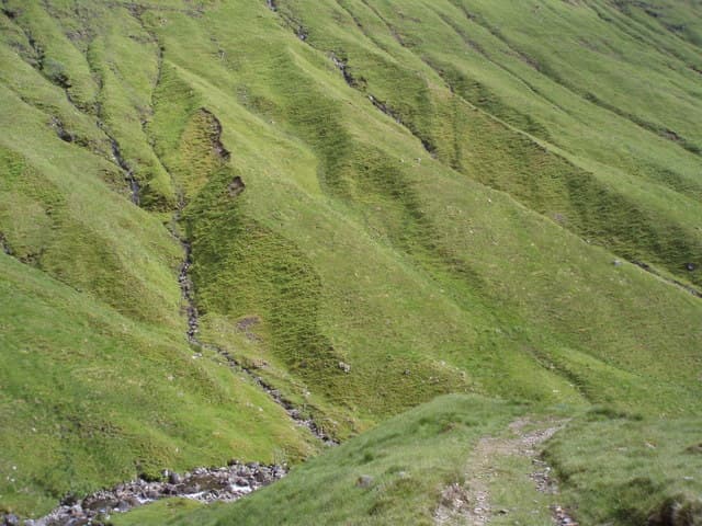
Stalkers track in the glen, then deep tussock and peat hag on the lower shoulder where progress is slow. The upper slopes firm up onto cropped grass and slabs of mica-schist. A small rocky knoll forms the actual summit with a wider plateau extending east.
In winter
The Monar hills receive serious drifted snow on the east-facing flanks where Atlantic systems dump their load. The remoteness multiplies any winter incident — the locked road means no quick exit. Ice axe and crampons are essential from December and a settled forecast is non-negotiable.
This hill is in the Creag Meagaidh SAIS forecast area. Check SAIS forecasts in winter (December–April).
Best time of year
Getting there
- Glasgow3h 19m
- Edinburgh4h 46m
OS maps: OS Landranger 25
Mobile signal: Poor. Remote Loch Monar area; no reliable coverage on most networks.
Current conditions
Daylight Today
- Sunrise
- 04:50
- Sunset
- 22:04
- Civil dawn
- 03:49
- Civil dusk
- 23:05
NOAA Solar Calculator · 17 July 2026
Around Carn na Breabaig on the SCOT network
Getting there, basing yourself, and what to do off the hill.
Carn na Breabaig — common questions
- How difficult is Carn na Breabaig?
- Carn na Breabaig carries a 4/5 (challenging) grade on the OutdoorSCOT scale. Count on about 13km, 557m of ascent and a 4-6 hour day on the standard route. Underfoot: Stalkers track in the glen, then deep tussock and peat hag on the lower shoulder where progress is slow.
- What is Carn na Breabaig's prominence?
- 177m of prominence. That's the vertical drop from the summit to the col that links Carn na Breabaig to the next higher ground.
- Where do I park for Carn na Breabaig?
- Most walkers start from NH072309 near Fort William. Verify the grid reference on an OS map before you set off — space is tight on busy summer weekends.
- When is the best time to climb Carn na Breabaig?
- March, April, May, June, July, August, September, October, November give the most reliable conditions on Carn na Breabaig. Beyond that window the high ground turns wintry: carry full mountain kit, be confident navigating, and check the SAIS avalanche forecast for the area.
- Is Carn na Breabaig dog-friendly?
- Yes, but dogs must be kept on a lead — there is livestock or ground-nesting bird interest on the route.
- Is there mobile signal on Carn na Breabaig?
- Poor. Remote Loch Monar area; no reliable coverage on most networks.
- Is Carn na Breabaig safe in winter?
- The Monar hills receive serious drifted snow on the east-facing flanks where Atlantic systems dump their load. The remoteness multiplies any winter incident — the locked road means no quick exit. Ice axe and crampons are essential from December and a settled forecast is non-negotiable.
Get the OutdoorSCOT weekly
One email a week — new route, hill and bothy guides, seasonal conditions and the odd hard-won lesson. No spam, unsubscribe in one click.