Munro · Central Highlands
An Riabhachan
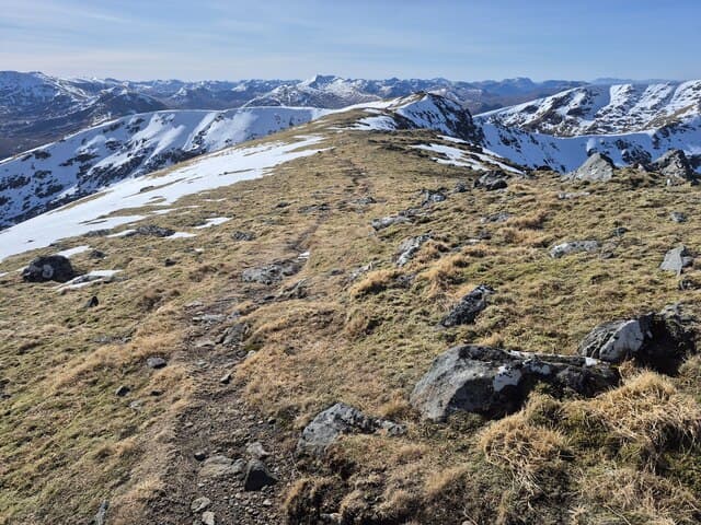
An Riabhachan — "the brindled or speckled one" — is the 1129m Munro on the long Mullardoch ridge between Sgurr na Lapaich and An Socach, in the great ridge north of Loch Mullardoch. The hill is one of the longest in Scotland: a 4km undulating crest with four named tops, all linked by broad easy ridge walking. Its position deep in the Mullardoch wilderness means few visit it alone — almost always it forms part of a multi-Munro traverse with its neighbours.
Quick facts
- Height
- 1129m/ 3704ft
- Prominence
- 302 m
- Distance
- ~18 km
- Ascent
- ~994 m
- Time
- 7–10 hrs
- Grid ref
- NH133344
- Parking
- NH220318
- Nearest city
- Inverness· 54km
- Dogs
- Dogs on lead required near livestockDog-friendly guide ↗
Height and prominence cross-checked against the Database of British and Irish Hills (CC BY).
No GPX track yet
Walked this route? Share your track to help other walkers.
Standard route
Glen road / cycle 35% · Open hillside 30% · Ridge walk 35%
The standard line is from the Mullardoch dam at the head of Glen Cannich. Most parties tackle the four Mullardoch Munros (An Socach, An Riabhachan, Sgurr na Lapaich and Carn nan Gobhar) in one long horseshoe — around 30km with 1800m of cumulative ascent. The standalone day for An Riabhachan via Loch a' Bhuilg path and the south ridge totals 18km with 994m of climbing.
Terrain
The Mullardoch loch-shore path is rough peat and boggy in patches. The climb onto the ridge is on grass and stone with no path. The connecting ridge across An Riabhachan is broad short grass and stones — long but easy underfoot. The summit cairn is at the western of the four tops; mist-navigation across the four tops takes care.
In winter
A long winter traverse with exposed ridge sections. Cornices on the north sides of the four tops are consistent through the season. The Mullardoch dam road can be slow in heavy snow. Phone signal is absent. The full four-Munro round in winter is a major undertaking and a long daylight commitment.
Kit for this: the winter Munro kit list · which boots take crampons
Best time of year
Getting there
- Glasgow3h 22m
- Edinburgh4h 46m
OS maps: OS Landranger 25
Mobile signal: No signal in Strathfarrar. The locked gate ensures you are committed to the approach before any coverage is lost. Download maps at home.
Current conditions
Daylight Today
- Sunrise
- 08:09
- Sunset
- 18:01
- Civil dawn
- 07:29
- Civil dusk
- 18:41
NOAA Solar Calculator · 22 October 2026
Pair with
Curated multi-hill combinations from An Riabhachan.
Around An Riabhachan on the SCOT network
Getting there, basing yourself, and what to do off the hill.
An Riabhachan — common questions
- Is An Riabhachan a hard climb?
- An Riabhachan is rated 5/5 (very challenging) on the OutdoorSCOT scale. The standard route covers about 18km with 994m of ascent and takes most walkers 7-10 hours. Ground conditions: The Mullardoch loch-shore path is rough peat and boggy in patches.
- How much drop does An Riabhachan have?
- The drop is 302m: measured from the summit of An Riabhachan down to the saddle joining it to higher terrain.
- Where's the parking for An Riabhachan?
- Park at NH220318. Double-check the grid reference on an OS map first; informal laybys here fill early in high season.
- What's the best month to climb An Riabhachan?
- Aim for May, June, July, August, September, October on An Riabhachan. In the remaining months treat it as a winter hill — full kit, solid navigation, and a look at the relevant SAIS avalanche forecast before you go.
- Can dogs go up An Riabhachan?
- Dogs are fine on a lead. The route passes livestock or ground-nesting bird habitat, so keep them close throughout.
- Will I get phone signal on An Riabhachan?
- No signal in Strathfarrar. The locked gate ensures you are committed to the approach before any coverage is lost. Download maps at home.
- Is An Riabhachan safe in winter?
- A long winter traverse with exposed ridge sections. Cornices on the north sides of the four tops are consistent through the season. The Mullardoch dam road can be slow in heavy snow. Phone signal is absent. The full four-Munro round in winter is a major undertaking and a long daylight commitment.
Get the OutdoorSCOT weekly
One email a week — new route, hill and bothy guides, seasonal conditions and the odd hard-won lesson. No spam, unsubscribe in one click.