Munro · Kintail
Beinn Fhionnlaidh
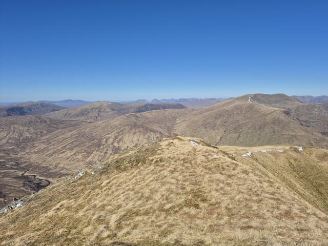
Beinn Fhionnlaidh (1004m) — "Findlay's hill" — is the long whaleback Munro that connects the head of Loch Mullardoch to the Carn Eige massif of Glen Affric. The hill is one of the most awkward to reach in Scotland: a long out-and-back from Carn Eige via the high ridge, or alternatively a remote approach across the head of Loch Mullardoch. The summit gives views deep into the heart of the Affric–Mullardoch wilderness.
Quick facts
- Height
- 1004.8m/ 3297ft
- Prominence
- 173 m
- Distance
- 17 km
- Ascent
- 884 m
- Time
- 6–9 hrs
- Grid ref
- NH115282
- Parking
- NH216242
- Nearest
- Fort William· Inverness 57km
- Dogs
- Dogs on lead required near livestockDog-friendly guide ↗
Height and prominence cross-checked against the Database of British and Irish Hills (CC BY).
No GPX track yet
Walked this route? Share your track to help other walkers.
Standard route
Glen path 40% · Open hillside 40% · Summit 20%
The most usual approach is from the head of Glen Affric (Loch Beinn a' Mheadhoin car park), taking the long path west along Loch Affric and Glen Affric to the head, then climbing Carn Eige via Mam Sodhail or the south ridge. From Carn Eige, descend the long broad north ridge of Beinn Fhionnlaidh and re-climb back — an additional 4km return with 350m of re-ascent. The classic three-Munro Affric round is around 28km with 1700m of ascent.
Terrain
The Glen Affric track is firm landrover surface for most of the long approach to the head of the loch. Above the glen the path becomes rough boggy hillside. The Carn Eige south ridge is mostly grass and broken rock. The long out-and-back north ridge to Beinn Fhionnlaidh is broad mossy turf with a substantial drop and re-climb. The summit is a large cairn on a broad whaleback top.
In winter
A serious remote winter expedition. The Affric approach is long; once over Carn Eige the further out-and-back to Beinn Fhionnlaidh becomes committing in shortened daylight. The west and north faces hold significant avalanche risk after westerly storms. Phone signal absent throughout. SAIS Northern Highlands applies. Most parties spread the round over two days with a bothy or wild camp at the head of the loch.
Best time of year
Getting there
- Glasgow3h 16m
- Edinburgh4h 41m
OS maps: OS Landranger 25
Mobile signal: Signal vanishes above 700m in Gleann Leac na Muidhe. The A82 has occasional coverage. Download maps before leaving the car.
Current conditions
Daylight Today
- Sunrise
- 05:00
- Sunset
- 21:54
- Civil dawn
- 04:03
- Civil dusk
- 22:51
NOAA Solar Calculator · 23 July 2026
Around Beinn Fhionnlaidh on the SCOT network
Getting there, basing yourself, and what to do off the hill.
Beinn Fhionnlaidh — common questions
- How hard is Beinn Fhionnlaidh?
- We grade Beinn Fhionnlaidh at 5/5, which puts it in very challenging territory. The usual route is around 17km with 884m of climbing; allow 6-9 hours. Underfoot: The Glen Affric track is firm landrover surface for most of the long approach to the head of the loch.
- What is Beinn Fhionnlaidh's prominence?
- 173m of prominence. That's the vertical drop from the summit to the col that links Beinn Fhionnlaidh to the next higher ground.
- Where do I park for Beinn Fhionnlaidh?
- Most walkers start from NH216242 near Fort William. Verify the grid reference on an OS map before you set off — space is tight on busy summer weekends.
- When is the best time to climb Beinn Fhionnlaidh?
- May, June, July, August, September, October give the most reliable conditions on Beinn Fhionnlaidh. Beyond that window the high ground turns wintry: carry full mountain kit, be confident navigating, and check the SAIS avalanche forecast for the area.
- Is Beinn Fhionnlaidh dog-friendly?
- Yes, but dogs must be kept on a lead — there is livestock or ground-nesting bird interest on the route.
- Is there mobile signal on Beinn Fhionnlaidh?
- Signal vanishes above 700m in Gleann Leac na Muidhe. The A82 has occasional coverage. Download maps before leaving the car.
- Is Beinn Fhionnlaidh safe in winter?
- A serious remote winter expedition. The Affric approach is long; once over Carn Eige the further out-and-back to Beinn Fhionnlaidh becomes committing in shortened daylight. The west and north faces hold significant avalanche risk after westerly storms. Phone signal absent throughout. SAIS Northern Highlands applies. Most parties spread the round over two days with a bothy or wild camp at the head of the loch.
Get the OutdoorSCOT weekly
One email a week — new route, hill and bothy guides, seasonal conditions and the odd hard-won lesson. No spam, unsubscribe in one click.