Munro · Kintail
Carn Eighe
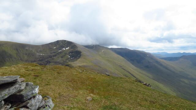
Carn Eighe is the highest hill north of the Great Glen at 1182m, the high point of the Glen Affric Munros and one of the most remote major summits in Britain. With 1147m of prominence it ranks as one of the most freestanding peaks in the country — only Ben Nevis, Ben Macdui and Ben More on Mull exceed it. The summit is a trig pillar in a stone windshelter on a small rocky platform at the western end of the great Mullardoch ridge, sharing a high bealach with Mam Sodhail to the south.
Quick facts
- Height
- 1182.8m/ 3881ft
- Prominence
- 1147 m
- Distance
- 19 km
- Ascent
- 1041 m
- Time
- 7–11 hrs
- Grid ref
- NH123261
- Parking
- NH200234
- Nearest
- Fort William· Inverness 57km
- Dogs
- Dogs on lead required near livestockDog-friendly guide ↗
Height and prominence cross-checked against the Database of British and Irish Hills (CC BY).
No GPX track yet
Walked this route? Share your track to help other walkers.
Standard route
Glen track 40% · Open hillside 30% · Ridge / summit 30%
The standard line is from the road end at Loch Affric, taking the stalkers path west into upper Glen Affric then climbing south up Coire Coulavie onto Mam Sodhail, and traversing north to Carn Eighe. Around 24km return with 1041m of net ascent — strong walkers add Beinn Fhionnlaidh, the more remote Munro 1km north of Carn Eighe. The northern approach from Loch Mullardoch is shorter but logistically more complex (private estate access through Cannich permits).
Terrain
The Affric stalkers paths are well-built into the glen. The climb up Coire Coulavie is on rough grass and rock with intermittent path; the connecting ridge between Mam Sodhail and Carn Eighe is broad short grass with no real exposure. The top is a shallow stony platform with a built shelter cairn at its centre. North onto Beinn Fhionnlaidh involves significant re-ascent and a steep grass-and-rock pull.
In winter
A serious winter day. The Coire Coulavie ascent and the Carn Eighe / Beinn Fhionnlaidh connection both develop avalanche risk after westerly storms. The connecting ridge holds cornices on its north side. Distance from the road end at Loch Affric and absence of phone signal make this a self-sufficient mountaineering day. SAIS Northern Highlands applies.
Best time of year
Getting there
- Glasgow3h 13m
- Edinburgh4h 39m
OS maps: OS Landranger 25
Mobile signal: Very poor signal throughout the Glen Affric approach. No signal at summit. The nearest coverage is at Cannich or Beauly. Pack a personal locator beacon for remote routes.
Current conditions
Daylight Today
- Sunrise
- 05:00
- Sunset
- 21:54
- Civil dawn
- 04:03
- Civil dusk
- 22:51
NOAA Solar Calculator · 23 July 2026
Pair with
Curated multi-hill combinations from Carn Eighe.
On a long-distance route
Carn Eighe sits within 5km of these named long-distance walks — useful for trail-pack rest days or section extensions.
Around Carn Eighe on the SCOT network
Getting there, basing yourself, and what to do off the hill.
Carn Eighe — common questions
- How hard is Carn Eighe?
- We grade Carn Eighe at 5/5, which puts it in very challenging territory. The usual route is around 19km with 1041m of climbing; allow 7-11 hours. Ground conditions: The Affric stalkers paths are well-built into the glen.
- How much drop does Carn Eighe have?
- The drop is 1147m: measured from the summit of Carn Eighe down to the saddle joining it to higher terrain.
- Where's the parking for Carn Eighe?
- Park at NH200234 near Fort William. Double-check the grid reference on an OS map first; informal laybys here fill early in high season.
- What's the best month to climb Carn Eighe?
- Aim for May, June, July, August, September, October on Carn Eighe. In the remaining months treat it as a winter hill — full kit, solid navigation, and a look at the relevant SAIS avalanche forecast before you go.
- Can dogs go up Carn Eighe?
- Dogs are fine on a lead. The route passes livestock or ground-nesting bird habitat, so keep them close throughout.
- Will I get phone signal on Carn Eighe?
- Very poor signal throughout the Glen Affric approach. No signal at summit. The nearest coverage is at Cannich or Beauly. Pack a personal locator beacon for remote routes.
- Is Carn Eighe safe in winter?
- A serious winter day. The Coire Coulavie ascent and the Carn Eighe / Beinn Fhionnlaidh connection both develop avalanche risk after westerly storms. The connecting ridge holds cornices on its north side. Distance from the road end at Loch Affric and absence of phone signal make this a self-sufficient mountaineering day. SAIS Northern Highlands applies.
Get the OutdoorSCOT weekly
One email a week — new route, hill and bothy guides, seasonal conditions and the odd hard-won lesson. No spam, unsubscribe in one click.