Long distance
Affric Kintail Way
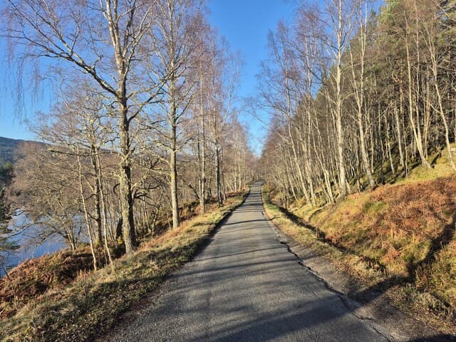
Connects Loch Ness to the west coast through Glen Affric, widely considered the most beautiful glen in Scotland. Remote, wild and deeply rewarding. Forest roads, tracks and glen paths, with a highest point of only 339m, but about 18 miles (29 km) with no public road between the River Affric car park and Morvich; about 1,630m of ascent by the operator’s stage figures (its homepage says over 6,000ft, its FAQ almost 1,800m); well-suited to walkers happy with a hostel, bothy or wild-camp night in the middle.
Quick facts
- Distance
- 71 km/ 44 mi
- Typical days
- 4
- Total ascent
- 1630 m
- Difficulty
- moderate
- Start → Finish
- Drumnadrochit → Morvich
- Best direction
- East to West
- Water sources
- Drumnadrochit, Cannich and Morvich provide tap water at the trailheads. Glen Affric burns are reliable and clean enough to treat. Carry 2L on the long Glen Affric day.
- Mobile signal
- EE/Vodafone reliable at Drumnadrochit and Cannich. No signal in Glen Affric — the whole interior of the route is signal-free. Morvich has signal again. The hostel at Alltbeithe is fully off-grid.
✔ Waymarked throughout
Planning to walk it? Read the full Affric Kintail Way guide — day-by-day itinerary, kit and logistics.
Approximate profile derived from per-stage ascent — accurate on total climb and pattern, not a pixel-precise GPX trace.
Our take
This is the route that experienced hillwalkers whisper about. Glen Affric is staggeringly beautiful — old Caledonian pine forest, lochs reflecting the sky, and a genuine sense of remoteness that the West Highland Way lost decades ago. The middle section has no road access and minimal phone signal. You carry everything or use the hostel at Alltbeithe and Camban bothy. Not for beginners.
Highlights
- Glen Affric — ancient Caledonian pine forest
- Loch Affric and Loch Beinn a Mheadhoin
- Alltbeithe youth hostel — one of the remotest in Scotland
- Descent to the west coast at Morvich
Day-by-day itinerary
A suggested 4-day schedule. Adjust to your fitness and conditions.
1Drumnadrochit to Cannich22km · 559m ascent
From the Loch Ness Hub through Craigmonie Woodland and the forestry roads of Glen Urquhart to Cannich, the last village before the wild heart of Glen Affric.
- Terrain
- Forest roads, woodland paths, a short public-road section. Moderate gradients.
- Overnight
- Cannich has B&Bs and a campsite (listed on the operator FAQ). Last resupply point.
- Stats
- Drumnadrochit → Cannich · 22km · ↑559m
2Cannich to River Affric car park19.5km · 583m ascent
Up Mullardoch Road and the forestry road above Comar Wood, down to Dog Falls, up through Scots pine to the Glen Affric viewpoint, then along Loch Beinn a' Mheadhoin to the Forestry and Land Scotland car park at River Affric.
- Terrain
- Forest roads and a rougher zig-zag track down to Dog Falls. Some wet sections.
- Overnight
- Nowhere to stay at the car park. Arrange a pick-up back to Cannich, wild camp along Loch Affric, or continue to Alltbeithe (20.5 miles / 33 km from Cannich).
- Stats
- Cannich → River Affric car park · 19.5km · ↑583m
3River Affric car park to Alltbeithe13.5km · 218m ascent
Along the south side of Loch Affric through Caledonian pine forest, past Athnamulloch, across the River Affric at Strawberry Cottage and up the river to Glen Affric Youth Hostel at Alltbeithe.
- Terrain
- Forest road, then path beside the River Affric. No road access beyond the car park.
- Overnight
- Glen Affric Youth Hostel (Alltbeithe) — book with Hostelling Scotland. Wild camping by the loch and river.
- Stats
- River Affric car park → Alltbeithe · 13.5km · ↑218m
4Alltbeithe to Morvich15.7km · 272m ascent
West into Fionngleann past Camban bothy, over the watershed at Cnoc Biodaig (339m, the highest point of the route), down a steep section above the Allt Grannda to Gleann Lichd, then the length of the glen to the NTS Ranger Station at Morvich.
- Terrain
- Rougher footpath, a steep rocky descent and small stream crossings, then a good glen track.
- Overnight
- Camban bothy (MBA, free) a short way west of Alltbeithe. Morvich has a caravan park; Shiel Bridge and Ratagan have B&Bs and a hostel.
- Stats
- Alltbeithe → Morvich · 15.7km · ↑272m
Hills along the route
Munros, Corbetts, Grahams and Donalds near the route line — extensions or rest-day options.
Transport
To start (Drumnadrochit)
Bus · Stagecoach Highland / Scottish Citylink
Inverness to Drumnadrochit (Stagecoach 17; Citylink 919)
Stagecoach 17 hourly; Citylink 919 every ~3 hours
~25–32 min journey. Inverness has direct trains from Edinburgh and Glasgow.
Check times & book →
From finish (Morvich)
Bus · Scottish Citylink
Shiel Bridge to Inverness (917) or Glasgow / Skye (915)
Up to 3 daily each direction
The operator says bus travellers alight at Allt a' Chruin on the A87, roughly 1.5 miles by road from the NTS Centre at Morvich (affrickintailway.com route overview, read 2026-10-27).
Check times & book →
Best months
Accommodation
Very limited. Cannich has B&Bs. Glen Affric Youth Hostel at Alltbeithe has no road access and must be booked directly with Hostelling Scotland well ahead; resupply is impossible there. Camban bothy (MBA) is a short way west. The operator lists campsites at Drumnadrochit, Cannich and Morvich; wild camping is the norm for the middle section.
Night-by-night guide: where to stay →Resupply
Carry all food from Drumnadrochit or Cannich. Cannich is the last resupply point before Morvich, with no shops in between — plan for the rest of the route from there.
Connect with
Chain into a longer expedition by combining with adjacent long-distance routes.
Affric Kintail Way + Cape Wrath Trail
Cape Wrath Trail crosses the Affric Kintail Way
Use the Affric Kintail Way as a wayfinding section of a Cape Wrath Trail north-west traverse.
Affric Kintail Way + Great Glen Way
Affric Kintail Way starts at Drumnadrochit on the Great Glen Way
Finish the Great Glen Way at Inverness, return south to Drumnadrochit, then walk the Affric Kintail Way west for a Highland figure-of-eight.
Current conditions
Weather at the start point (Drumnadrochit)
Daylight Today
- Sunrise
- 07:20
- Sunset
- 16:44
- Civil dawn
- 06:39
- Civil dusk
- 17:24
NOAA Solar Calculator · 28 October 2026
Share your experience
Walked the Affric Kintail Way? Help others plan their trip.
Getting to and from the Affric Kintail Way
Train and town anchors at each end of the route — on TripSCOT.
Start: Inverness station
Highland capital — Cairngorms east side, Affric, Far North via bus/car
22km from Drumnadrochit
tripscot.co.uk
On TripSCOTFinish: Plockton station
Coastal Wester Ross; Plockton village; Skye Bridge approach
21km from Morvich
tripscot.co.uk
On TripSCOTStock up: Inverness
Highland capital — gateway to Cairngorms, Affric, Far North
tripscot.co.uk