Corbett · Central Highlands
Sguman Coinntich
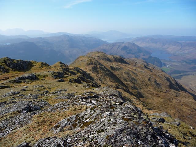
Sguman Coinntich is the 879m Corbett guarding the head of Glen Elchaig at the eastern side, between Killilan and the Falls of Glomach. The mountain is part of the remote group north of the A87 road around Loch Long, accessed from the small settlement of Killilan via a long estate track up the glen. From the top, the Kintail ridge of the Five Sisters spreads out to the south and Glen Affric runs away to the east. Often paired with Faochaig from the same bike-in approach.
Quick facts
- Height
- 879m/ 2884ft
- Prominence
- 415 m
- Distance
- 22 km
- Ascent
- 870 m
- Time
- 6–9 hrs
- Grid ref
- NG976303
- Parking
- NG937302
- Nearest
- Fort William· Inverness 70km
- Dogs
- Dogs on lead required near livestockDog-friendly guide ↗
Height and prominence cross-checked against the Database of British and Irish Hills (CC BY).
No GPX track yet
Walked this route? Share your track to help other walkers.
Standard route
glen track 30% · rough heather 40% · grassy upper slopes 20% · summit area 10%
Drive to Killilan at the road end west of Loch Long (NG937302). Cycle or walk the estate track east up Glen Elchaig for around 7km to Iron Lodge, then strike south up the open hillside onto Sguman Coinntich's broad north ridge. The summit cairn perches on a rocky outcrop. For the natural pair, drop south-west to the bealach and climb Faochaig. Allow 8–9 hours on foot, 6–7 with a bike.
Terrain
Excellent estate track up Glen Elchaig — bike-friendly and quick. Off the track the going turns to mixed grass and heather, with peat hags concentrating in the bealach. The summit area is firmer underfoot, with a small cairn perched on a rock outcrop. The connecting ridge to Faochaig is broad and easy.
In winter
A long winter day with a serious access penalty: Killilan's single-track approach is exposed to drift and storms, the bike becomes useless once the track ices up, and there is no phone signal anywhere in Glen Elchaig. Best as a two-day round with overnight at Iron Lodge bothy.
This hill is in the Creag Meagaidh SAIS forecast area. Check SAIS forecasts in winter (December–April).
Best time of year
Getting there
- Glasgow3h 23m
- Edinburgh4h 53m
OS maps: OS Landranger 25
Mobile signal: No signal in Glen Elchaig; one of Scotland's more remote western glens
Current conditions
Daylight Today
- Sunrise
- 04:44
- Sunset
- 22:11
- Civil dawn
- 03:41
- Civil dusk
- 23:13
NOAA Solar Calculator · 13 July 2026
Pair with
Curated multi-hill combinations from Sguman Coinntich.
Around Sguman Coinntich on the SCOT network
Getting there, basing yourself, and what to do off the hill.
Sguman Coinntich — common questions
- Is Sguman Coinntich a hard climb?
- Sguman Coinntich is rated 3/5 (moderately challenging) on the OutdoorSCOT scale. The standard route covers about 22km with 870m of ascent and takes most walkers 6-9 hours. Underfoot: Excellent estate track up Glen Elchaig — bike-friendly and quick.
- What is Sguman Coinntich's prominence?
- 415m of prominence. That's the vertical drop from the summit to the col that links Sguman Coinntich to the next higher ground.
- Where do I park for Sguman Coinntich?
- Most walkers start from NG937302 near Fort William. Verify the grid reference on an OS map before you set off — space is tight on busy summer weekends.
- When is the best time to climb Sguman Coinntich?
- May, June, July, August, September give the most reliable conditions on Sguman Coinntich. Beyond that window the high ground turns wintry: carry full mountain kit, be confident navigating, and check the SAIS avalanche forecast for the area.
- Is Sguman Coinntich dog-friendly?
- Yes, but dogs must be kept on a lead — there is livestock or ground-nesting bird interest on the route.
- Is there mobile signal on Sguman Coinntich?
- No signal in Glen Elchaig; one of Scotland's more remote western glens
- Is Sguman Coinntich safe in winter?
- A long winter day with a serious access penalty: Killilan's single-track approach is exposed to drift and storms, the bike becomes useless once the track ices up, and there is no phone signal anywhere in Glen Elchaig. Best as a two-day round with overnight at Iron Lodge bothy.
Get the OutdoorSCOT weekly
One email a week — new route, hill and bothy guides, seasonal conditions and the odd hard-won lesson. No spam, unsubscribe in one click.