Munro · Kintail
Sgurr Fhuaran
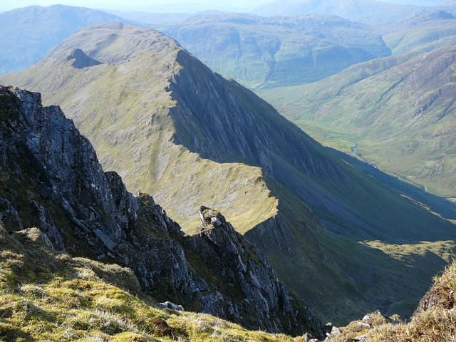
Sgurr Fhuaran (1068m) is the highest and most dramatic of the Five Sisters of Kintail — the great north–south wall of summits that rises straight out of Loch Duich on Scotland's west coast. The Five Sisters traverse from Glen Shiel to Morvich is one of the classic Scottish ridge walks, with constant exposure, technical scrambling sections and views west to Skye and the Cuillin. Sgurr Fhuaran sits roughly in the middle of the ridge and presents the steepest north face of the group.
Quick facts
- Height
- 1068.8m/ 3507ft
- Prominence
- 665 m
- Distance
- ~18 km
- Ascent
- ~941 m
- Time
- 7–10 hrs
- Grid ref
- NG978166
- Parking
- NG990135
- Nearest city
- Fort William· 44km
- Dogs
- Dogs on lead required near livestockDog-friendly guide ↗
Height and prominence cross-checked against the Database of British and Irish Hills (CC BY).
No GPX track yet
Walked this route? Share your track to help other walkers.
Standard route
Glen path 20% · Steep hillside 35% · Kintail ridge 45%
The standard line is the full Five Sisters traverse, climbing the steep south-east ridge from the Bealach an Lapain on the A87, traversing north over Sgurr nan Spainteach, Sgurr na Ciste Duibhe, Sgurr na Carnach, Sgurr Fhuaran, Sgurr nan Saighead and Sgurr na Moraich, then descending to Shiel Bridge or Morvich. Around 14km with 1600m of cumulative ascent. The Fhuaran-only direct line from Morvich up the north-west spur is 12km with 1100m up.
Terrain
The Bealach an Lapain initial climb from the A87 is 700m of relentless steep grass with no path until the bealach is reached. The ridge above is narrow throughout, with rocky steps that need a hand on rock in several places. The drop off Sgurr Fhuaran to the north is steep and intimidating but the path stays away from the edge. Descent off Sgurr na Moraich to Morvich is steep grass that ices in spring.
In winter
A serious winter ridge traverse. The narrow crest develops continuous cornicing on the east side. The descent off Bealach an Lapain in winter requires care — the steep grass becomes hard névé. The Morvich descent off the north end is exposed to westerly weather. Phone signal is absent throughout the ridge. Full winter mountaineering kit and competence essential.
Kit for this: the winter Munro kit list · which boots take crampons
Best time of year
Getting there
- Glasgow3h 8m
- Edinburgh4h 41m
OS maps: OS Landranger 33
Mobile signal: No coverage above 600m in Kintail. The Morvich car park has intermittent signal. Download maps from home — signal is consistently poor throughout Glen Shiel.
Current conditions
Daylight Today
- Sunrise
- 08:09
- Sunset
- 18:02
- Civil dawn
- 07:30
- Civil dusk
- 18:42
NOAA Solar Calculator · 22 October 2026
Pair with
Curated multi-hill combinations from Sgurr Fhuaran.
Around Sgurr Fhuaran on the SCOT network
Getting there, basing yourself, and what to do off the hill.
Sgurr Fhuaran — common questions
- Is Sgurr Fhuaran a hard climb?
- Sgurr Fhuaran is rated 5/5 (very challenging) on the OutdoorSCOT scale. The standard route covers about 18km with 941m of ascent and takes most walkers 7-10 hours. Ground conditions: The Bealach an Lapain initial climb from the A87 is 700m of relentless steep grass with no path until the bealach is reached.
- How much drop does Sgurr Fhuaran have?
- The drop is 665m: measured from the summit of Sgurr Fhuaran down to the saddle joining it to higher terrain.
- Where's the parking for Sgurr Fhuaran?
- Park at NG990135. Double-check the grid reference on an OS map first; informal laybys here fill early in high season.
- What's the best month to climb Sgurr Fhuaran?
- Aim for May, June, July, August, September on Sgurr Fhuaran. In the remaining months treat it as a winter hill — full kit, solid navigation, and a look at the relevant SAIS avalanche forecast before you go.
- Can dogs go up Sgurr Fhuaran?
- Dogs are fine on a lead. The route passes livestock or ground-nesting bird habitat, so keep them close throughout.
- Will I get phone signal on Sgurr Fhuaran?
- No coverage above 600m in Kintail. The Morvich car park has intermittent signal. Download maps from home — signal is consistently poor throughout Glen Shiel.
- Is Sgurr Fhuaran safe in winter?
- A serious winter ridge traverse. The narrow crest develops continuous cornicing on the east side. The descent off Bealach an Lapain in winter requires care — the steep grass becomes hard névé. The Morvich descent off the north end is exposed to westerly weather. Phone signal is absent throughout the ridge. Full winter mountaineering kit and competence essential.
Get the OutdoorSCOT weekly
One email a week — new route, hill and bothy guides, seasonal conditions and the odd hard-won lesson. No spam, unsubscribe in one click.